![](/images/other/stat-length.png)
![Randonnée A pied Sainte-Croix - La Gittaz-Col de l'Aigullon - Photo](https://media.geolcdn.com/t/1900/400/6946b4e0-6068-4cfa-bbe6-24c55651ec09.jpeg&format=pjpeg&maxdim=2)
La Gittaz-Col de l'Aigullon
SityTrail - itinéraires balisés pédestres
Tous les sentiers balisés d’Europe GUIDE+
![Longueur](/images/other/stat-length.png)
Longueur
4,1 km
![Altitude max](https://static1.geolcdn.com/siteimages/upload/files/1508320355ic_sort_altitude_max_24dp.png)
Altitude max
1347 m
![Dénivelé positif](https://static1.geolcdn.com/siteimages/upload/files/1508320355ic_sort_den_pos_24dp.png)
Dénivelé positif
219 m
![Km-Effort](/images/other/stat-length.png)
Km-Effort
6,4 km
![Altitude min](https://static1.geolcdn.com/siteimages/upload/files/1508320355ic_sort_altitude_min_24dp.png)
Altitude min
1131 m
![Dénivelé négatif](https://static1.geolcdn.com/siteimages/upload/files/1508320355ic_sort_den_neg_24dp.png)
Dénivelé négatif
21 m
![Boucle](https://static1.geolcdn.com/siteimages/upload/files/16400158638029165_repeat_loop_refresh_sync_direction_icon.png)
Boucle
Non
Balise
Date de création :
2022-02-14 08:45:18.426
Dernière modification :
2022-02-14 08:45:18.426
![A pied](https://static1.geolcdn.com/sitytour/trail-icons/100.png)
1h26
Difficulté : Facile
![Scannez ce code QR pour ouvrir la randonnée dans l'application SityTrail](https://capi.geolives.com/qq0zvz2zws4bq2lad0pu/sitytour/trails/3105872/qr.png?size=200)
Application GPS de randonnée GRATUITE
À propos
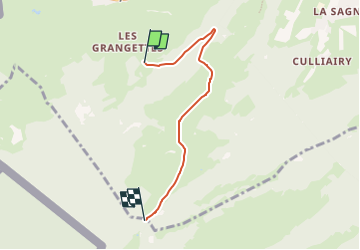
Randonnée A pied de 4,1 km à découvrir à Vaud, District du Jura-Nord vaudois, Sainte-Croix. Cette randonnée est proposée par SityTrail - itinéraires balisés pédestres.
Description
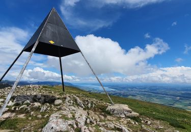
Symbole: losange jaune
Localisation
Pays :
Suisse
Région :
Vaud
Département/Province :
District du Jura-Nord vaudois
Commune :
Sainte-Croix
Localité :
Unknown
Départ:(Dec)
Départ:(UTM)
306657 ; 5187185 (32T) N.
Commentaires
Randonnées à proximité
![Randonnée Marche Les Fourgs - Le Stratégique - Doubs - Photo](https://media.geolcdn.com/t/375/260/ext.jpg?maxdim=2&url=https%3A%2F%2Fservices.sitytrail.com%2FGeolivesWS%2FDownloadMedia.ashx%3FTrailID%3D108935%26Media%3D2626_1.jpg)
![Marche Marche](https://static1.geolcdn.com/sitytour/trail-icons/101.png)
Le Stratégique - Doubs
Marche
Moyen
(1)
Les Fourgs,
Bourgogne-Franche-Comté,
Doubs,
France
![](/images/other/stat-length.png)
8,3 km | 10,6 km-effort
2h 45min
![](https://static1.geolcdn.com/siteimages/upload/files/16400158638029165_repeat_loop_refresh_sync_direction_icon.png)
Oui
![Randonnée A pied Sainte-Croix - Sainte Croix-La Gittaz - Photo](https://media.geolcdn.com/t/375/260/7c0dcc60-9777-42cd-b5f3-05d60f03159f.jpeg&format=jpg&maxdim=2)
![A pied A pied](https://static1.geolcdn.com/sitytour/trail-icons/100.png)
Sainte Croix-La Gittaz
A pied
Facile
Sainte-Croix,
Vaud,
District du Jura-Nord vaudois,
Suisse
![](/images/other/stat-length.png)
5,7 km | 8,3 km-effort
1h 53min
![](https://static1.geolcdn.com/siteimages/upload/files/16400158638029165_repeat_loop_refresh_sync_direction_icon.png)
Non
![Randonnée A pied Sainte-Croix - Chemin de la Gare - Photo](https://media.geolcdn.com/t/375/260/1c01c3b8-df2a-4423-9b92-ab96556853c0.jpeg&format=jpg&maxdim=2)
![A pied A pied](https://static1.geolcdn.com/sitytour/trail-icons/100.png)
Chemin de la Gare
A pied
Facile
Sainte-Croix,
Vaud,
District du Jura-Nord vaudois,
Suisse
![](/images/other/stat-length.png)
6,5 km | 8,6 km-effort
1h 57min
![](https://static1.geolcdn.com/siteimages/upload/files/16400158638029165_repeat_loop_refresh_sync_direction_icon.png)
Non
![Randonnée Marche Jougne - Aiguilles de Baulmes - Suisse - Photo](https://media.geolcdn.com/t/375/260/ext.jpg?maxdim=2&url=https%3A%2F%2Fstatic1.geolcdn.com%2Fsiteimages%2Fupload%2Ffiles%2F1553511878bg_sport_marche.png)
![Marche Marche](https://static1.geolcdn.com/sitytour/trail-icons/101.png)
Aiguilles de Baulmes - Suisse
Marche
Difficile
(1)
Jougne,
Bourgogne-Franche-Comté,
Doubs,
France
![](/images/other/stat-length.png)
16,4 km | 26 km-effort
5h 33min
![](https://static1.geolcdn.com/siteimages/upload/files/16400158638029165_repeat_loop_refresh_sync_direction_icon.png)
Oui
![Randonnée Marche Les Fourgs - Belvedere de la roche Sarrasine - Photo](https://media.geolcdn.com/t/375/260/ext.jpg?maxdim=2&url=https%3A%2F%2Fstatic1.geolcdn.com%2Fsiteimages%2Fupload%2Ffiles%2F1553511878bg_sport_marche.png)
![Marche Marche](https://static1.geolcdn.com/sitytour/trail-icons/101.png)
Belvedere de la roche Sarrasine
Marche
Difficile
(1)
Les Fourgs,
Bourgogne-Franche-Comté,
Doubs,
France
![](/images/other/stat-length.png)
12,4 km | 17 km-effort
3h 51min
![](https://static1.geolcdn.com/siteimages/upload/files/16400158638029165_repeat_loop_refresh_sync_direction_icon.png)
Oui
![Randonnée Ski de fond Les Fourgs - Piste du Voirnon - Photo](https://media.geolcdn.com/t/375/260/4d46f533-833e-4cab-9d13-d16310de5eba.jpg&format=jpg&maxdim=2)
![Ski de fond Ski de fond](https://static1.geolcdn.com/sitytour/trail-icons/502.png)
Piste du Voirnon
Ski de fond
Facile
Les Fourgs,
Bourgogne-Franche-Comté,
Doubs,
France
![](/images/other/stat-length.png)
11,8 km | 15,2 km-effort
3h 39min
![](https://static1.geolcdn.com/siteimages/upload/files/16400158638029165_repeat_loop_refresh_sync_direction_icon.png)
Oui
![Randonnée A pied Les Fourgs - Le Sentier des Bornes - Photo](https://media.geolcdn.com/t/375/260/4777e0b5-35d9-430b-b18b-01a7bbd1a8dc.jpeg&format=jpg&maxdim=2)
![A pied A pied](https://static1.geolcdn.com/sitytour/trail-icons/100.png)
Le Sentier des Bornes
A pied
Facile
Les Fourgs,
Bourgogne-Franche-Comté,
Doubs,
France
![](/images/other/stat-length.png)
6,4 km | 8 km-effort
1h 48min
![](https://static1.geolcdn.com/siteimages/upload/files/16400158638029165_repeat_loop_refresh_sync_direction_icon.png)
Non
![Randonnée Marche Sainte-Croix - le Chasseron par les avattes - Photo](https://media.geolcdn.com/t/375/260/ext.jpg?maxdim=2&url=https%3A%2F%2Fservices.sitytrail.com%2FGeolivesWS%2FDownloadMedia.ashx%3FTrailID%3D966325%26Media%3Dfix__20180507162134.jpg)
![Marche Marche](https://static1.geolcdn.com/sitytour/trail-icons/101.png)
le Chasseron par les avattes
Marche
Moyen
Sainte-Croix,
Vaud,
District du Jura-Nord vaudois,
Suisse
![](/images/other/stat-length.png)
13,3 km | 20 km-effort
4h 18min
![](https://static1.geolcdn.com/siteimages/upload/files/16400158638029165_repeat_loop_refresh_sync_direction_icon.png)
Oui
![Randonnée Marche Jougne - aiguilles de Baulmes et retour Suchet - Photo](https://media.geolcdn.com/t/375/260/c17e4977-34fe-43ba-93d4-0a17ab33486a.jpg&format=jpg&maxdim=2)
![Marche Marche](https://static1.geolcdn.com/sitytour/trail-icons/101.png)
aiguilles de Baulmes et retour Suchet
Marche
Très facile
Jougne,
Bourgogne-Franche-Comté,
Doubs,
France
![](/images/other/stat-length.png)
23 km | 37 km-effort
6h 31min
![](https://static1.geolcdn.com/siteimages/upload/files/16400158638029165_repeat_loop_refresh_sync_direction_icon.png)
Oui