![](/images/other/stat-length.png)
![Randonnée A pied Burghaun - Burgpfad - Photo](https://media.geolcdn.com/t/1900/400/ext.pjpeg?maxdim=2&url=https%3A%2F%2Fstatic1.geolcdn.com%2Fsiteimages%2Fupload%2Ffiles%2F1545311037marcheuse_200dpi.jpg)
Burgpfad
SityTrail - itinéraires balisés pédestres
Tous les sentiers balisés d’Europe PRO
![Longueur](/images/other/stat-length.png)
Longueur
3,2 km
![Altitude max](https://static1.geolcdn.com/siteimages/upload/files/1508320355ic_sort_altitude_max_24dp.png)
Altitude max
371 m
![Dénivelé positif](https://static1.geolcdn.com/siteimages/upload/files/1508320355ic_sort_den_pos_24dp.png)
Dénivelé positif
32 m
![Km-Effort](/images/other/stat-length.png)
Km-Effort
3,6 km
![Altitude min](https://static1.geolcdn.com/siteimages/upload/files/1508320355ic_sort_altitude_min_24dp.png)
Altitude min
343 m
![Dénivelé négatif](https://static1.geolcdn.com/siteimages/upload/files/1508320355ic_sort_den_neg_24dp.png)
Dénivelé négatif
19 m
![Boucle](https://static1.geolcdn.com/siteimages/upload/files/16400158638029165_repeat_loop_refresh_sync_direction_icon.png)
Boucle
Non
Balise
Date de création :
2022-02-11 20:54:46.427
Dernière modification :
2022-02-11 20:54:46.427
![A pied](https://static1.geolcdn.com/sitytour/trail-icons/100.png)
49m
Difficulté : Facile
![Scannez ce code QR pour ouvrir la randonnée dans l'application SityTrail](https://capi.geolives.com/qq0zvz2zws4bq2lad0pu/sitytour/trails/3102325/qr.png?size=200)
Application GPS de randonnée GRATUITE
À propos
Randonnée A pied de 3,2 km à découvrir à Hesse, Landkreis Fulda, Burghaun. Cette randonnée est proposée par SityTrail - itinéraires balisés pédestres.
Description
Randonnée créée par Heimat- und Verkehrsverein Haunetal.
Symbole: weißes Schild mit Text "Burgpfad"
Site web: https://www.haunetal.de/seite/153242/wandern-sehenswürdigkeiten.html
Localisation
Pays :
Allemagne
Région :
Hesse
Département/Province :
Landkreis Fulda
Commune :
Burghaun
Localité :
Unknown
Départ:(Dec)
Départ:(UTM)
550860 ; 5619917 (32U) N.
Commentaires
Randonnées à proximité
![Randonnée A pied Haunetal - Turmweg - Kurzvariante - Photo](https://media.geolcdn.com/t/375/260/ext.jpg?maxdim=2&url=https%3A%2F%2Fmedia.geolcdn.com%2Ff%2F570c5804-2c02-4f4f-b6e0-2405b75b7cad.jpeg)
![A pied A pied](https://static1.geolcdn.com/sitytour/trail-icons/100.png)
Turmweg - Kurzvariante
A pied
Facile
Haunetal,
Hesse,
Landkreis Hersfeld-Rotenburg,
Allemagne
![](/images/other/stat-length.png)
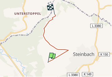
5,8 km | 7 km-effort
1h 35min
![](https://static1.geolcdn.com/siteimages/upload/files/16400158638029165_repeat_loop_refresh_sync_direction_icon.png)
Non
![Randonnée A pied Burghaun - Burghaun Rhön 1 - Photo](https://media.geolcdn.com/t/375/260/ext.jpg?maxdim=2&url=https%3A%2F%2Fmedia.geolcdn.com%2Ff%2F523f2cb1-0bd1-4267-874e-ba7bb486de5a.jpeg)
![A pied A pied](https://static1.geolcdn.com/sitytour/trail-icons/100.png)
Burghaun Rhön 1
A pied
Facile
Burghaun,
Hesse,
Landkreis Fulda,
Allemagne
![](/images/other/stat-length.png)
5,3 km | 6,3 km-effort
1h 25min
![](https://static1.geolcdn.com/siteimages/upload/files/16400158638029165_repeat_loop_refresh_sync_direction_icon.png)
Non
![Randonnée A pied Burghaun - Rhönrundweg 2 Burghaun - Photo](https://media.geolcdn.com/t/375/260/ext.jpg?maxdim=2&url=https%3A%2F%2Fstatic1.geolcdn.com%2Fsiteimages%2Fupload%2Ffiles%2F1545311037marcheuse_200dpi.jpg)
![A pied A pied](https://static1.geolcdn.com/sitytour/trail-icons/100.png)
Rhönrundweg 2 Burghaun
A pied
Facile
Burghaun,
Hesse,
Landkreis Fulda,
Allemagne
![](/images/other/stat-length.png)
3,6 km | 5,1 km-effort
1h 9min
![](https://static1.geolcdn.com/siteimages/upload/files/16400158638029165_repeat_loop_refresh_sync_direction_icon.png)
Non