Randonnée A pied Oberhof - Rundweg Oberhof - Photo

Tous les sentiers balisés d’Europe PRO

© OpenStreetMap contributors
Longueur
Longueur
6 km
Altitude max
Altitude max
866 m
Dénivelé positif
Dénivelé positif
173 m
Km-Effort
Km-Effort  
8,1 km
Altitude min
Altitude min
772 m
Dénivelé négatif
Dénivelé négatif
106 m
Boucle
Boucle
Non
Balise
Balise
Date de création :
2022-02-11 20:48:52.351
Dernière modification :
2022-02-11 20:48:52.351

(0 Avis)

A pied
A pied
1h49
Difficulté : Facile

Scannez ce code QR pour ouvrir la randonnée dans l'application SityTrail

Application GPS de randonnée GRATUITE

Logo SityTrail SityTrail

IGN / Instituts géographiques

Télécharger SityTrail sur l'App Store Télécharger SityTrail sur Google Play

Logo SityTrail SityTrail World

Le monde est à vous

Télécharger SityTrail sur l'App Store Télécharger SityTrail sur Google Play Télécharger SityTrail sur Huawei AppGallery

À propos

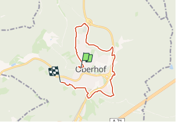
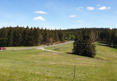
Randonnée A pied de 6 km à découvrir à Thuringe, Landkreis Schmalkalden-Meiningen, Oberhof. Cette randonnée est proposée par SityTrail - itinéraires balisés pédestres.

Description

Randonnée créée par Oberhofer Freizeit und Tourismus GmbH.

Symbole: wandernder Schneemann - Schneemann "Flocke" mit Wanderstock

Photos

Localisation

Pays :
Allemagne
Région :
Thuringe
Département/Province :
Landkreis Schmalkalden-Meiningen
Commune :
Oberhof
Localité :
Unknown
Départ:(UTM)
621605 ; 5618646 (32U) N.

Randonnées à proximité

Randonnée A pied Geratal - Rundwanderweg Lütsche-Flößgraben - Photo
A pied
PRO

A pied

Facile
Geratal, Thuringe, Ilm-Kreis, Allemagne
11,3 km | 14 km-effort
3h 10min
Non
Randonnée A pied Oberhof - Rennsteig-Leiter Luisenthal - Photo
A pied
PRO

A pied

Facile
Oberhof, Thuringe, Landkreis Schmalkalden-Meiningen, Allemagne
9,3 km | 11,2 km-effort
2h 33min
Non
Randonnée A pied Oberhof - Rennsteig-Leiter Zella-Mehlis - Photo
A pied
PRO

A pied

Facile
Oberhof, Thuringe, Landkreis Schmalkalden-Meiningen, Allemagne
3,6 km | 5,3 km-effort
1h 12min
Non
Randonnée A pied Inconnu - Gipfelwanderweg Suhl (Thüringer Wald) - Photo
A pied
PRO

A pied

Moyen
Inconnu, Thuringe, Suhl, Allemagne
18 km | 24 km-effort
5h 31min
Non
Randonnée A pied Geratal - Alter Flößgraben - Photo
A pied
PRO

A pied

Facile
Geratal, Thuringe, Ilm-Kreis, Allemagne
12,2 km | 14,8 km-effort
3h 21min
Non
Randonnée A pied Steinbach-Hallenberg - DE-Gelber Strich - Photo
A pied
PRO

A pied

Facile
Steinbach-Hallenberg, Thuringe, Landkreis Schmalkalden-Meiningen, Allemagne
3,7 km | 5,6 km-effort
1h 16min
Non
Randonnée A pied Luisenthal - Herrenweg - Photo
A pied
PRO

A pied

Facile
Luisenthal, Thuringe, Landkreis Gotha, Allemagne
3,5 km | 4,4 km-effort
1h 0min
Non
Randonnée A pied Inconnu - Wilderer-Pfad - Photo
A pied
PRO

A pied

Facile
Inconnu, Thuringe, Suhl, Allemagne
8,3 km | 12,6 km-effort
2h 51min
Oui


Fermer
Mes abonnements