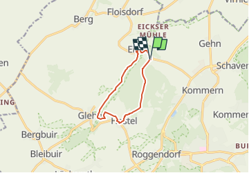
![](/images/other/stat-length.png)
![Randonnée A pied Mechernich - EifelSchleife Eickser Busch - Photo](https://media.geolcdn.com/t/1900/400/072e47f6-f82f-4b70-8d89-5bfb8fc4db70.jpeg&format=pjpeg&maxdim=2)
EifelSchleife Eickser Busch
SityTrail - itinéraires balisés pédestres
Tous les sentiers balisés d’Europe GUIDE+
![Longueur](/images/other/stat-length.png)
![Altitude max](https://static1.geolcdn.com/siteimages/upload/files/1508320355ic_sort_altitude_max_24dp.png)
![Dénivelé positif](https://static1.geolcdn.com/siteimages/upload/files/1508320355ic_sort_den_pos_24dp.png)
![Km-Effort](/images/other/stat-length.png)
![Altitude min](https://static1.geolcdn.com/siteimages/upload/files/1508320355ic_sort_altitude_min_24dp.png)
![Dénivelé négatif](https://static1.geolcdn.com/siteimages/upload/files/1508320355ic_sort_den_neg_24dp.png)
![Boucle](https://static1.geolcdn.com/siteimages/upload/files/16400158638029165_repeat_loop_refresh_sync_direction_icon.png)
![A pied](https://static1.geolcdn.com/sitytour/trail-icons/100.png)
2h09
Difficulté : Facile
![Scannez ce code QR pour ouvrir la randonnée dans l'application SityTrail](https://capi.geolives.com/qq0zvz2zws4bq2lad0pu/sitytour/trails/3102089/qr.png?size=200)
Application GPS de randonnée GRATUITE
À propos
Randonnée A pied de 7,8 km à découvrir à Rhénanie-du-Nord-Westphalie, Euskirchen, Mechernich. Cette randonnée est proposée par SityTrail - itinéraires balisés pédestres.
Description
Randonnée créée par Nordeifel Tourismus GmbH.
Symbole: quadratisches Logo oben blaue Fläche (Himmel) unten grüne Fläche (Berg/Landschaft), unten bis nach oben auf dem Grünen geschlängelt weiße Linie (Weg), oben links in weißer Schrift „EifelSchleifen“
Localisation
Commentaires
Randonnées à proximité
![Randonnée A pied Mechernich - EifelSpur Soweit das Auge reicht - Photo](https://media.geolcdn.com/t/375/260/c70cb833-41f8-4d90-824d-5fcd1544f78d.jpeg&format=jpg&maxdim=2)
![A pied A pied](https://static1.geolcdn.com/sitytour/trail-icons/100.png)
A pied
![](/images/other/stat-length.png)
![](https://static1.geolcdn.com/siteimages/upload/files/16400158638029165_repeat_loop_refresh_sync_direction_icon.png)
![Randonnée A pied Mechernich - EifelSchleife Altusknipp-Weg - Photo](https://media.geolcdn.com/t/375/260/a1c826eb-46f8-4939-a400-ff876a4c0f14.jpeg&format=jpg&maxdim=2)
![A pied A pied](https://static1.geolcdn.com/sitytour/trail-icons/100.png)
A pied
![](/images/other/stat-length.png)
![](https://static1.geolcdn.com/siteimages/upload/files/16400158638029165_repeat_loop_refresh_sync_direction_icon.png)
![Randonnée A pied Mechernich - EifelSchleife Kommerner Fachwerkidylle - Photo](https://media.geolcdn.com/t/375/260/1ca075b4-2c73-439c-8adb-5a0359d22b2d.jpeg&format=jpg&maxdim=2)
![A pied A pied](https://static1.geolcdn.com/sitytour/trail-icons/100.png)
A pied
![](/images/other/stat-length.png)
![](https://static1.geolcdn.com/siteimages/upload/files/16400158638029165_repeat_loop_refresh_sync_direction_icon.png)
![Randonnée A pied Mechernich - EifelSchleife Burg Satzvey - Photo](https://media.geolcdn.com/t/375/260/06c6e2b8-53ab-44c9-a958-97487b3c0d6f.jpeg&format=jpg&maxdim=2)
![A pied A pied](https://static1.geolcdn.com/sitytour/trail-icons/100.png)
A pied
![](/images/other/stat-length.png)
![](https://static1.geolcdn.com/siteimages/upload/files/16400158638029165_repeat_loop_refresh_sync_direction_icon.png)
![Randonnée A pied Mechernich - Eifeltor Panorama - Route - Photo](https://media.geolcdn.com/t/375/260/072e47f6-f82f-4b70-8d89-5bfb8fc4db70.jpeg&format=jpg&maxdim=2)
![A pied A pied](https://static1.geolcdn.com/sitytour/trail-icons/100.png)
A pied
![](/images/other/stat-length.png)
![](https://static1.geolcdn.com/siteimages/upload/files/16400158638029165_repeat_loop_refresh_sync_direction_icon.png)
![Randonnée A pied Zülpich - EifelSchleife Via Agrippa - Photo](https://media.geolcdn.com/t/375/260/875ef8b2-bef5-48c5-99c8-f4f04af005df.jpeg&format=jpg&maxdim=2)
![A pied A pied](https://static1.geolcdn.com/sitytour/trail-icons/100.png)
A pied
![](/images/other/stat-length.png)
![](https://static1.geolcdn.com/siteimages/upload/files/16400158638029165_repeat_loop_refresh_sync_direction_icon.png)
![Randonnée A pied Zülpich - EifelSchleife Berg und Tal - Photo](https://media.geolcdn.com/t/375/260/abf2ff02-d07e-4691-9e09-5d1a32857f26.jpeg&format=jpg&maxdim=2)
![A pied A pied](https://static1.geolcdn.com/sitytour/trail-icons/100.png)
A pied
![](/images/other/stat-length.png)
![](https://static1.geolcdn.com/siteimages/upload/files/16400158638029165_repeat_loop_refresh_sync_direction_icon.png)
![Randonnée A pied Mechernich - Hochwildpark Rheinland - Route - Photo](https://media.geolcdn.com/t/375/260/06c6e2b8-53ab-44c9-a958-97487b3c0d6f.jpeg&format=jpg&maxdim=2)
![A pied A pied](https://static1.geolcdn.com/sitytour/trail-icons/100.png)
A pied
![](/images/other/stat-length.png)
![](https://static1.geolcdn.com/siteimages/upload/files/16400158638029165_repeat_loop_refresh_sync_direction_icon.png)
![Randonnée A pied Mechernich - Breitenbenden Rundweg 6 - Photo](https://media.geolcdn.com/t/375/260/f8c103ca-3bb9-46d6-a875-c465fa8b2d99.jpeg&format=jpg&maxdim=2)
![A pied A pied](https://static1.geolcdn.com/sitytour/trail-icons/100.png)
A pied
![](/images/other/stat-length.png)
![](https://static1.geolcdn.com/siteimages/upload/files/16400158638029165_repeat_loop_refresh_sync_direction_icon.png)