


21 km | 27 km-effort
![Randonnée A pied Steimel - [RM] Rotmilanwanderweg - Photo](https://media.geolcdn.com/t/1900/400/bd3a678d-fa90-49ee-85ba-df82f5331819.jpeg&format=pjpeg&maxdim=2)

Tous les sentiers balisés d’Europe GUIDE+


Application GPS de randonnée GRATUITE
 SityTrail
IGN / Instituts géographiques
SityTrail World
Le monde est à vous
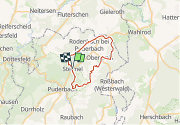
Randonnée A pied de 18,5 km à découvrir à Rhénanie-Palatinat, Landkreis Neuwied, Steimel. Cette randonnée est proposée par SityTrail - itinéraires balisés pédestres.
Randonnée créée par Verbandsgemeinde Puderbach.
Symbole: Symbol "Rotmilan" auf weißem Grund
Site web: https://puderbacher-land.de/wandern-im-puderbacher-land/
![Randonnée A pied Steimel - [RM] Rotmilanwanderweg - Photo 1](https://media.geolcdn.com/t/2048/auto/383317a3-fef2-4dde-95a9-51b046cc6974.jpeg&format=jpg&maxdim=0 "Randonnée A pied Steimel - [RM] Rotmilanwanderweg - Photo 1")
![Randonnée A pied Steimel - [RM] Rotmilanwanderweg - Photo 2](https://media.geolcdn.com/t/2048/auto/3754dc7d-2042-43ff-8909-7dd5819088d0.jpeg&format=jpg&maxdim=0 "Randonnée A pied Steimel - [RM] Rotmilanwanderweg - Photo 2")
![Randonnée A pied Steimel - [RM] Rotmilanwanderweg - Photo 3](https://media.geolcdn.com/t/2048/auto/be699b48-cb45-4f81-b6ca-80fcf98ff16b.jpeg&format=jpg&maxdim=0 "Randonnée A pied Steimel - [RM] Rotmilanwanderweg - Photo 3")
![Randonnée A pied Steimel - [RM] Rotmilanwanderweg - Photo 4](https://media.geolcdn.com/t/2048/auto/fa97aefc-fe1b-4a6b-b3fb-32cfedd299a7.jpeg&format=jpg&maxdim=0 "Randonnée A pied Steimel - [RM] Rotmilanwanderweg - Photo 4")
![Randonnée A pied Steimel - [RM] Rotmilanwanderweg - Photo 5](https://media.geolcdn.com/t/2048/auto/271ee6de-e088-44bb-88a1-bc7f505ee717.jpeg&format=jpg&maxdim=0 "Randonnée A pied Steimel - [RM] Rotmilanwanderweg - Photo 5")
![Randonnée A pied Steimel - [RM] Rotmilanwanderweg - Photo 6](https://media.geolcdn.com/t/2048/auto/b89de801-c7d5-488c-8951-c9efb63fcf80.jpeg&format=jpg&maxdim=0 "Randonnée A pied Steimel - [RM] Rotmilanwanderweg - Photo 6")
![Randonnée A pied Steimel - [RM] Rotmilanwanderweg - Photo 7](https://media.geolcdn.com/t/2048/auto/1130f79b-1d68-4afd-8c9d-1edddcf67acf.jpeg&format=jpg&maxdim=0 "Randonnée A pied Steimel - [RM] Rotmilanwanderweg - Photo 7")
![Randonnée A pied Steimel - [RM] Rotmilanwanderweg - Photo 8](https://media.geolcdn.com/t/2048/auto/bd3a852d-7cee-41ca-a389-9cc0d922227a.jpeg&format=jpg&maxdim=0 "Randonnée A pied Steimel - [RM] Rotmilanwanderweg - Photo 8")
![Randonnée A pied Steimel - [RM] Rotmilanwanderweg - Photo 9](https://media.geolcdn.com/t/2048/auto/bd3a678d-fa90-49ee-85ba-df82f5331819.jpeg&format=jpg&maxdim=0 "Randonnée A pied Steimel - [RM] Rotmilanwanderweg - Photo 9")
![Randonnée A pied Steimel - [RM] Rotmilanwanderweg - Photo 10](https://media.geolcdn.com/t/2048/auto/b44d01e5-107e-429b-8a9d-702e33827965.jpeg&format=jpg&maxdim=0 "Randonnée A pied Steimel - [RM] Rotmilanwanderweg - Photo 10")
![Randonnée A pied Puderbach - [B3] Burgweg 3 - Photo](https://media.geolcdn.com/t/375/260/bd3a678d-fa90-49ee-85ba-df82f5331819.jpeg&format=jpg&maxdim=2)
A pied
A pied
A pied