![](/images/other/stat-length.png)
![Randonnée A pied Oelde - Pflaumenwanderweg - Photo](https://media.geolcdn.com/t/1900/400/45d54f1e-a9d3-4af2-8066-e3eeb72c2dd9.jpeg&format=pjpeg&maxdim=2)
Pflaumenwanderweg
SityTrail - itinéraires balisés pédestres
Tous les sentiers balisés d’Europe GUIDE+
![Longueur](/images/other/stat-length.png)
Longueur
10,5 km
![Altitude max](https://static1.geolcdn.com/siteimages/upload/files/1508320355ic_sort_altitude_max_24dp.png)
Altitude max
155 m
![Dénivelé positif](https://static1.geolcdn.com/siteimages/upload/files/1508320355ic_sort_den_pos_24dp.png)
Dénivelé positif
141 m
![Km-Effort](/images/other/stat-length.png)
Km-Effort
12,4 km
![Altitude min](https://static1.geolcdn.com/siteimages/upload/files/1508320355ic_sort_altitude_min_24dp.png)
Altitude min
103 m
![Dénivelé négatif](https://static1.geolcdn.com/siteimages/upload/files/1508320355ic_sort_den_neg_24dp.png)
Dénivelé négatif
141 m
![Boucle](https://static1.geolcdn.com/siteimages/upload/files/16400158638029165_repeat_loop_refresh_sync_direction_icon.png)
Boucle
Oui
Balise
Date de création :
2022-02-11 20:28:16.401
Dernière modification :
2022-02-11 20:28:16.401
![A pied](https://static1.geolcdn.com/sitytour/trail-icons/100.png)
2h48
Difficulté : Facile
![Scannez ce code QR pour ouvrir la randonnée dans l'application SityTrail](https://capi.geolives.com/qq0zvz2zws4bq2lad0pu/sitytour/trails/3101852/qr.png?size=200)
Application GPS de randonnée GRATUITE
À propos
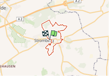
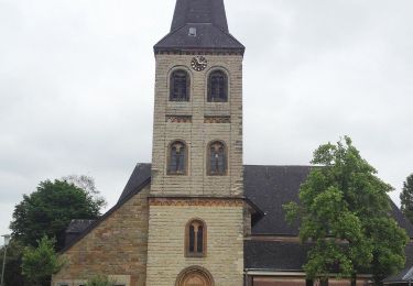
Randonnée A pied de 10,5 km à découvrir à Rhénanie-du-Nord-Westphalie, Kreis Warendorf, Oelde. Cette randonnée est proposée par SityTrail - itinéraires balisés pédestres.
Description
Randonnée créée par Stromberger Pflaume g.U..
Symbole: Weiße Pflaume auf violettem Grund
Site web: https://www.stromberger-pflaume.de/wanderweg/
Localisation
Pays :
Allemagne
Région :
Rhénanie-du-Nord-Westphalie
Département/Province :
Kreis Warendorf
Commune :
Oelde
Localité :
Unknown
Départ:(Dec)
Départ:(UTM)
444993 ; 5739480 (32U) N.
Commentaires
Randonnées à proximité
![Randonnée A pied Verl - Verler Kirchwege - Photo](https://media.geolcdn.com/t/375/260/02c298a3-0840-4bbf-b00a-bca5e99cf1fb.jpeg&format=jpg&maxdim=2)
![A pied A pied](https://static1.geolcdn.com/sitytour/trail-icons/100.png)
Verler Kirchwege
A pied
Facile
Verl,
Rhénanie-du-Nord-Westphalie,
Kreis Gütersloh,
Allemagne
![](/images/other/stat-length.png)
7,1 km | 7,6 km-effort
1h 44min
![](https://static1.geolcdn.com/siteimages/upload/files/16400158638029165_repeat_loop_refresh_sync_direction_icon.png)
Non
![Randonnée A pied Harsewinkel - Prälatenweg Marienfeld - Photo](https://media.geolcdn.com/t/375/260/d964a764-e262-45bc-8346-81c213467cb9.jpeg&format=jpg&maxdim=2)
![A pied A pied](https://static1.geolcdn.com/sitytour/trail-icons/100.png)
Prälatenweg Marienfeld
A pied
Difficile
Harsewinkel,
Rhénanie-du-Nord-Westphalie,
Kreis Gütersloh,
Allemagne
![](/images/other/stat-length.png)
31 km | 34 km-effort
7h 43min
![](https://static1.geolcdn.com/siteimages/upload/files/16400158638029165_repeat_loop_refresh_sync_direction_icon.png)
Oui
![Randonnée A pied Warendorf - Blaue Runde, ca. 4,5 km - Photo](https://media.geolcdn.com/t/375/260/a6a99ae4-36fb-4906-b09e-09983a1e2537.jpeg&format=jpg&maxdim=2)
![A pied A pied](https://static1.geolcdn.com/sitytour/trail-icons/100.png)
Blaue Runde, ca. 4,5 km
A pied
Facile
Warendorf,
Rhénanie-du-Nord-Westphalie,
Kreis Warendorf,
Allemagne
![](/images/other/stat-length.png)
4,4 km | 4,9 km-effort
1h 6min
![](https://static1.geolcdn.com/siteimages/upload/files/16400158638029165_repeat_loop_refresh_sync_direction_icon.png)
Oui
![Randonnée A pied Oelde - Großer Rundweg Geisterholz - Photo](https://media.geolcdn.com/t/375/260/378638ed-c635-4702-aad4-18c46603a9e6.jpeg&format=jpg&maxdim=2)
![A pied A pied](https://static1.geolcdn.com/sitytour/trail-icons/100.png)
Großer Rundweg Geisterholz
A pied
Facile
Oelde,
Rhénanie-du-Nord-Westphalie,
Kreis Warendorf,
Allemagne
![](/images/other/stat-length.png)
7,4 km | 8,4 km-effort
1h 54min
![](https://static1.geolcdn.com/siteimages/upload/files/16400158638029165_repeat_loop_refresh_sync_direction_icon.png)
Oui
![Randonnée A pied Oelde - Raute Kerkherrenweg - Photo](https://media.geolcdn.com/t/375/260/ead93180-9d0d-458a-a304-bb5450dff9c0.jpeg&format=jpg&maxdim=2)
![A pied A pied](https://static1.geolcdn.com/sitytour/trail-icons/100.png)
Raute Kerkherrenweg
A pied
Facile
Oelde,
Rhénanie-du-Nord-Westphalie,
Kreis Warendorf,
Allemagne
![](/images/other/stat-length.png)
3,5 km | 4 km-effort
53min
![](https://static1.geolcdn.com/siteimages/upload/files/16400158638029165_repeat_loop_refresh_sync_direction_icon.png)
Non
![Randonnée A pied Inconnu - A2 - Brackwede - Photo](https://media.geolcdn.com/t/375/260/496cfd8d-58e8-4d76-9af5-34dea688c1e8.jpeg&format=jpg&maxdim=2)
![A pied A pied](https://static1.geolcdn.com/sitytour/trail-icons/100.png)
A2 - Brackwede
A pied
Facile
Inconnu,
Rhénanie-du-Nord-Westphalie,
Bielefeld,
Allemagne
![](/images/other/stat-length.png)
5,8 km | 6,5 km-effort
1h 28min
![](https://static1.geolcdn.com/siteimages/upload/files/16400158638029165_repeat_loop_refresh_sync_direction_icon.png)
Oui
![Randonnée A pied Wadersloh - Liesborn Wanderweg W1 - Photo](https://media.geolcdn.com/t/375/260/ext.jpg?maxdim=2&url=https%3A%2F%2Fstatic1.geolcdn.com%2Fsiteimages%2Fupload%2Ffiles%2F1545311037marcheuse_200dpi.jpg)
![A pied A pied](https://static1.geolcdn.com/sitytour/trail-icons/100.png)
Liesborn Wanderweg W1
A pied
Facile
Wadersloh,
Rhénanie-du-Nord-Westphalie,
Kreis Warendorf,
Allemagne
![](/images/other/stat-length.png)
4,6 km | 4,9 km-effort
1h 7min
![](https://static1.geolcdn.com/siteimages/upload/files/16400158638029165_repeat_loop_refresh_sync_direction_icon.png)
Non
![Randonnée Marche Geseke - Geseke - Westereiden - Photo](https://media.geolcdn.com/t/375/260/ext.jpg?maxdim=2&url=https%3A%2F%2Fstatic1.geolcdn.com%2Fsiteimages%2Fupload%2Ffiles%2F1553511878bg_sport_marche.png)
![Marche Marche](https://static1.geolcdn.com/sitytour/trail-icons/101.png)
Geseke - Westereiden
Marche
Moyen
Geseke,
Rhénanie-du-Nord-Westphalie,
Kreis Soest,
Allemagne
![](/images/other/stat-length.png)
15,7 km | 18 km-effort
3h 59min
![](https://static1.geolcdn.com/siteimages/upload/files/16400158638029165_repeat_loop_refresh_sync_direction_icon.png)
Non