![](/images/other/stat-length.png)
![Randonnée A pied Weischlitz - Burgstein-Lehrpfad - Photo](https://media.geolcdn.com/t/1900/400/3daa1b46-b4b3-422f-be91-5d0136acdf90.jpeg&format=pjpeg&maxdim=2)
Burgstein-Lehrpfad
SityTrail - itinéraires balisés pédestres
Tous les sentiers balisés d’Europe GUIDE+
![Longueur](/images/other/stat-length.png)
Longueur
8,7 km
![Altitude max](https://static1.geolcdn.com/siteimages/upload/files/1508320355ic_sort_altitude_max_24dp.png)
Altitude max
603 m
![Dénivelé positif](https://static1.geolcdn.com/siteimages/upload/files/1508320355ic_sort_den_pos_24dp.png)
Dénivelé positif
228 m
![Km-Effort](/images/other/stat-length.png)
Km-Effort
11,8 km
![Altitude min](https://static1.geolcdn.com/siteimages/upload/files/1508320355ic_sort_altitude_min_24dp.png)
Altitude min
433 m
![Dénivelé négatif](https://static1.geolcdn.com/siteimages/upload/files/1508320355ic_sort_den_neg_24dp.png)
Dénivelé négatif
224 m
![Boucle](https://static1.geolcdn.com/siteimages/upload/files/16400158638029165_repeat_loop_refresh_sync_direction_icon.png)
Boucle
Oui
Balise
Date de création :
2022-02-11 20:01:52.3
Dernière modification :
2022-02-11 20:01:52.3
![A pied](https://static1.geolcdn.com/sitytour/trail-icons/100.png)
2h40
Difficulté : Facile
![Scannez ce code QR pour ouvrir la randonnée dans l'application SityTrail](https://capi.geolives.com/qq0zvz2zws4bq2lad0pu/sitytour/trails/3101327/qr.png?size=200)
Application GPS de randonnée GRATUITE
À propos
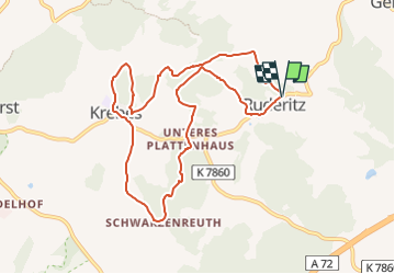
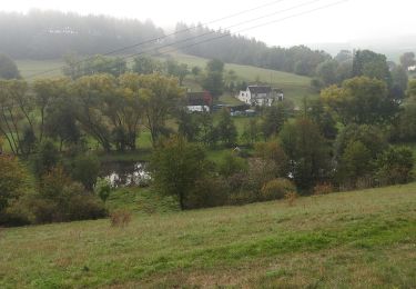
Randonnée A pied de 8,7 km à découvrir à Saxe, Vogtlandkreis, Weischlitz. Cette randonnée est proposée par SityTrail - itinéraires balisés pédestres.
Description
Randonnée créée par Gemeinde Weischlitz.
Localisation
Pays :
Allemagne
Région :
Saxe
Département/Province :
Vogtlandkreis
Commune :
Weischlitz
Localité :
Unknown
Départ:(Dec)
Départ:(UTM)
287754 ; 5589593 (33U) N.
Commentaires
Randonnées à proximité
![Randonnée A pied Krásná - [Z] Krásná - nejzápadnější bod ČR - Photo](https://media.geolcdn.com/t/375/260/631889f3-3839-4731-be0e-23b816dd81e6.jpeg&format=jpg&maxdim=2)
![A pied A pied](https://static1.geolcdn.com/sitytour/trail-icons/100.png)
[Z] Krásná - nejzápadnější bod ČR
A pied
Facile
Krásná,
Severozápad,
Karlovarský kraj,
République Tchèque
![](/images/other/stat-length.png)
6,5 km | 8,4 km-effort
1h 54min
![](https://static1.geolcdn.com/siteimages/upload/files/16400158638029165_repeat_loop_refresh_sync_direction_icon.png)
Non
![Randonnée A pied Bad Elster - Sohl Markneukirchen - Photo](https://media.geolcdn.com/t/375/260/8439981d-e117-4bd5-a401-3ce5beedc8fa.jpeg&format=jpg&maxdim=2)
![A pied A pied](https://static1.geolcdn.com/sitytour/trail-icons/100.png)
Sohl Markneukirchen
A pied
Facile
Bad Elster,
Saxe,
Vogtlandkreis,
Allemagne
![](/images/other/stat-length.png)
5,5 km | 7,5 km-effort
1h 42min
![](https://static1.geolcdn.com/siteimages/upload/files/16400158638029165_repeat_loop_refresh_sync_direction_icon.png)
Non
![Randonnée A pied Konradsreuth - Rundwanderweg 1 Oberkotzau - Photo](https://media.geolcdn.com/t/375/260/9a8978f4-ce11-4aa8-9d5c-1c9a9df6ebba.jpeg&format=jpg&maxdim=2)
![A pied A pied](https://static1.geolcdn.com/sitytour/trail-icons/100.png)
Rundwanderweg 1 Oberkotzau
A pied
Facile
Konradsreuth,
Bavière,
Landkreis Hof,
Allemagne
![](/images/other/stat-length.png)
8,7 km | 11,5 km-effort
2h 36min
![](https://static1.geolcdn.com/siteimages/upload/files/16400158638029165_repeat_loop_refresh_sync_direction_icon.png)
Oui
![Randonnée A pied Rehau - Mit der Arnika in den Rehauer Forst - Photo](https://media.geolcdn.com/t/375/260/23fc0b98-8189-4d37-b9c8-7d7db54e3cca.jpeg&format=jpg&maxdim=2)
![A pied A pied](https://static1.geolcdn.com/sitytour/trail-icons/100.png)
Mit der Arnika in den Rehauer Forst
A pied
Facile
Rehau,
Bavière,
Landkreis Hof,
Allemagne
![](/images/other/stat-length.png)
9,5 km | 11,6 km-effort
2h 37min
![](https://static1.geolcdn.com/siteimages/upload/files/16400158638029165_repeat_loop_refresh_sync_direction_icon.png)
Non
![Randonnée A pied Rehau - Mit der Arnika zum Kornberg - Photo](https://media.geolcdn.com/t/375/260/ff87cd7e-0ce7-49c9-a223-bd18eebec758.jpeg&format=jpg&maxdim=2)
![A pied A pied](https://static1.geolcdn.com/sitytour/trail-icons/100.png)
Mit der Arnika zum Kornberg
A pied
Facile
Rehau,
Bavière,
Landkreis Hof,
Allemagne
![](/images/other/stat-length.png)
11,7 km | 15 km-effort
3h 24min
![](https://static1.geolcdn.com/siteimages/upload/files/16400158638029165_repeat_loop_refresh_sync_direction_icon.png)
Non
![Randonnée A pied Schauenstein - Paradies-Weg OS 26 - Photo](https://media.geolcdn.com/t/375/260/787da7a9-e5c3-4536-bb8c-ec4f0c42b757.jpeg&format=jpg&maxdim=2)
![A pied A pied](https://static1.geolcdn.com/sitytour/trail-icons/100.png)
Paradies-Weg OS 26
A pied
Facile
Schauenstein,
Bavière,
Landkreis Hof,
Allemagne
![](/images/other/stat-length.png)
10,1 km | 14,2 km-effort
3h 13min
![](https://static1.geolcdn.com/siteimages/upload/files/16400158638029165_repeat_loop_refresh_sync_direction_icon.png)
Oui
![Randonnée A pied Berg - Schwamma-Weg US73 - Photo](https://media.geolcdn.com/t/375/260/80348f5a-f04a-42f0-a0b2-ab2a72fba677.jpeg&format=jpg&maxdim=2)
![A pied A pied](https://static1.geolcdn.com/sitytour/trail-icons/100.png)
Schwamma-Weg US73
A pied
Facile
Berg,
Bavière,
Landkreis Hof,
Allemagne
![](/images/other/stat-length.png)
5,2 km | 6,2 km-effort
1h 25min
![](https://static1.geolcdn.com/siteimages/upload/files/16400158638029165_repeat_loop_refresh_sync_direction_icon.png)
Non
![Randonnée A pied Schleiz - Rundwanderweg Weckersdorf - Photo](https://media.geolcdn.com/t/375/260/856984f1-ab26-4606-af82-5cd19993a97f.jpeg&format=jpg&maxdim=2)
![A pied A pied](https://static1.geolcdn.com/sitytour/trail-icons/100.png)
Rundwanderweg Weckersdorf
A pied
Facile
Schleiz,
Thuringe,
Saale-Orla-Kreis,
Allemagne
![](/images/other/stat-length.png)
12,4 km | 15,3 km-effort
3h 28min
![](https://static1.geolcdn.com/siteimages/upload/files/16400158638029165_repeat_loop_refresh_sync_direction_icon.png)
Oui
![Randonnée A pied Schauenstein - Fuchsbau-Weg OS 22 - Photo](https://media.geolcdn.com/t/375/260/fa50fc44-bbc2-4cc9-8ab0-3793ac520739.jpeg&format=jpg&maxdim=2)
![A pied A pied](https://static1.geolcdn.com/sitytour/trail-icons/100.png)
Fuchsbau-Weg OS 22
A pied
Facile
Schauenstein,
Bavière,
Landkreis Hof,
Allemagne
![](/images/other/stat-length.png)
3,4 km | 4,7 km-effort
1h 4min
![](https://static1.geolcdn.com/siteimages/upload/files/16400158638029165_repeat_loop_refresh_sync_direction_icon.png)
Non