![](/images/other/stat-length.png)
![Randonnée A pied Unknown - Panoramaweg - Etappe 3 - Photo](https://media.geolcdn.com/t/1900/400/bab156c0-31c8-4076-8528-62ab4461ec9b.jpeg&format=pjpeg&maxdim=2)
Panoramaweg - Etappe 3
SityTrail - itinéraires balisés pédestres
Tous les sentiers balisés d’Europe GUIDE+
![Longueur](/images/other/stat-length.png)
![Altitude max](https://static1.geolcdn.com/siteimages/upload/files/1508320355ic_sort_altitude_max_24dp.png)
![Dénivelé positif](https://static1.geolcdn.com/siteimages/upload/files/1508320355ic_sort_den_pos_24dp.png)
![Km-Effort](/images/other/stat-length.png)
![Altitude min](https://static1.geolcdn.com/siteimages/upload/files/1508320355ic_sort_altitude_min_24dp.png)
![Dénivelé négatif](https://static1.geolcdn.com/siteimages/upload/files/1508320355ic_sort_den_neg_24dp.png)
![Boucle](https://static1.geolcdn.com/siteimages/upload/files/16400158638029165_repeat_loop_refresh_sync_direction_icon.png)
![A pied](https://static1.geolcdn.com/sitytour/trail-icons/100.png)
4h43
Difficulté : Moyen
![Scannez ce code QR pour ouvrir la randonnée dans l'application SityTrail](https://capi.geolives.com/qq0zvz2zws4bq2lad0pu/sitytour/trails/3101058/qr.png?size=200)
Application GPS de randonnée GRATUITE
À propos
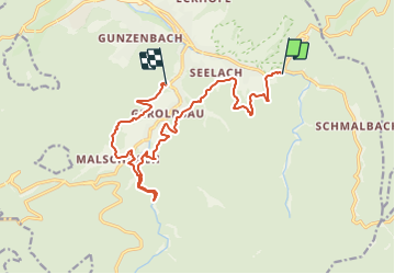
Randonnée A pied de 14,4 km à découvrir à Bade-Wurtemberg, Baden-Baden. Cette randonnée est proposée par SityTrail - itinéraires balisés pédestres.
Description
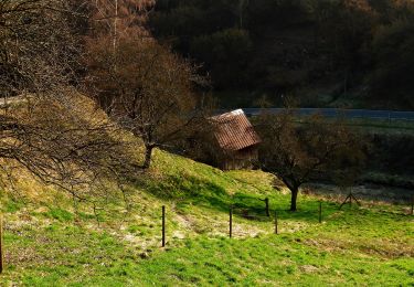
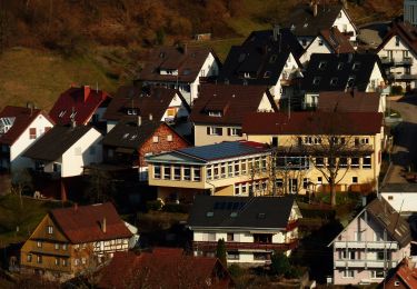
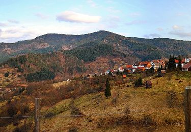
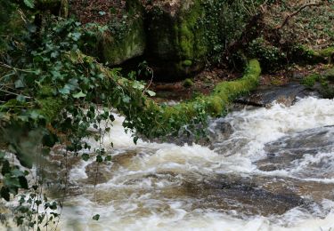
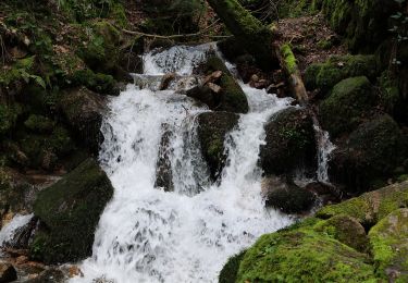
Blühende Täler so weit das Auge reicht, wildromantische Wasserfälle und herausragende Pflanzenvielfalt bis in die Tiefen des Schwarzwaldes: Die dritte Etappe führt zu kraftvollen Orten inmitten der Natur.
Site web: https://visit.baden-baden.de/media/touren/panoramaweg-etappe-3-forellenhof-zur-geroldsauer-muehle
Localisation
Commentaires
Randonnées à proximité
![Randonnée A pied Forbach - Heimatweg - Photo](https://media.geolcdn.com/t/375/260/00a23653-c851-473b-8713-9bfb67757f2b.jpeg&format=jpg&maxdim=2)
![A pied A pied](https://static1.geolcdn.com/sitytour/trail-icons/100.png)
A pied
![](/images/other/stat-length.png)
![](https://static1.geolcdn.com/siteimages/upload/files/16400158638029165_repeat_loop_refresh_sync_direction_icon.png)
![Randonnée A pied Forbach - Hölleweg - Photo](https://media.geolcdn.com/t/375/260/ffbb1037-d636-464f-bd54-e42f82948e57.jpeg&format=jpg&maxdim=2)
![A pied A pied](https://static1.geolcdn.com/sitytour/trail-icons/100.png)
A pied
![](/images/other/stat-length.png)
![](https://static1.geolcdn.com/siteimages/upload/files/16400158638029165_repeat_loop_refresh_sync_direction_icon.png)
![Randonnée A pied Forbach - Riedkopfrundweg - Photo](https://media.geolcdn.com/t/375/260/a590b01a-ee10-4d9f-beb6-8980dc73ca0d.jpeg&format=jpg&maxdim=2)
![A pied A pied](https://static1.geolcdn.com/sitytour/trail-icons/100.png)
A pied
![](/images/other/stat-length.png)
![](https://static1.geolcdn.com/siteimages/upload/files/16400158638029165_repeat_loop_refresh_sync_direction_icon.png)
![Randonnée A pied Forbach - Glücksweg - Photo](https://media.geolcdn.com/t/375/260/ecc156b9-baa3-4401-a228-dd3a18f21f12.jpeg&format=jpg&maxdim=2)
![A pied A pied](https://static1.geolcdn.com/sitytour/trail-icons/100.png)
A pied
![](/images/other/stat-length.png)
![](https://static1.geolcdn.com/siteimages/upload/files/16400158638029165_repeat_loop_refresh_sync_direction_icon.png)
![Randonnée A pied Forbach - Panoramaweg - Photo](https://media.geolcdn.com/t/375/260/ecc156b9-baa3-4401-a228-dd3a18f21f12.jpeg&format=jpg&maxdim=2)
![A pied A pied](https://static1.geolcdn.com/sitytour/trail-icons/100.png)
A pied
![](/images/other/stat-length.png)
![](https://static1.geolcdn.com/siteimages/upload/files/16400158638029165_repeat_loop_refresh_sync_direction_icon.png)
![Randonnée A pied Forbach - Hardtkopfrundweg - Photo](https://media.geolcdn.com/t/375/260/a590b01a-ee10-4d9f-beb6-8980dc73ca0d.jpeg&format=jpg&maxdim=2)
![A pied A pied](https://static1.geolcdn.com/sitytour/trail-icons/100.png)
A pied
![](/images/other/stat-length.png)
![](https://static1.geolcdn.com/siteimages/upload/files/16400158638029165_repeat_loop_refresh_sync_direction_icon.png)
![Randonnée A pied Forbach - Betende-Hände-Weg - Photo](https://media.geolcdn.com/t/375/260/a590b01a-ee10-4d9f-beb6-8980dc73ca0d.jpeg&format=jpg&maxdim=2)
![A pied A pied](https://static1.geolcdn.com/sitytour/trail-icons/100.png)
A pied
![](/images/other/stat-length.png)
![](https://static1.geolcdn.com/siteimages/upload/files/16400158638029165_repeat_loop_refresh_sync_direction_icon.png)
![Randonnée A pied - Kreuzfelsen-Rundweg - Photo](https://media.geolcdn.com/t/375/260/f9dace17-edc3-438b-97fc-f5c4b4d7572a.jpeg&format=jpg&maxdim=2)
![A pied A pied](https://static1.geolcdn.com/sitytour/trail-icons/100.png)
A pied
![](/images/other/stat-length.png)
![](https://static1.geolcdn.com/siteimages/upload/files/16400158638029165_repeat_loop_refresh_sync_direction_icon.png)
![Randonnée A pied - Einmündung Littersbach - Bernickel - Photo](https://media.geolcdn.com/t/375/260/bea8d541-e7ea-450b-a556-e23b7df34437.jpeg&format=jpg&maxdim=2)
![A pied A pied](https://static1.geolcdn.com/sitytour/trail-icons/100.png)
A pied
![](/images/other/stat-length.png)
![](https://static1.geolcdn.com/siteimages/upload/files/16400158638029165_repeat_loop_refresh_sync_direction_icon.png)