![](/images/other/stat-length.png)
![Randonnée A pied Hördt - Tulpenbaumweg - Photo](https://media.geolcdn.com/t/1900/400/ext.pjpeg?maxdim=2&url=https%3A%2F%2Fmedia.geolcdn.com%2Ff%2F1c56e93e-93d0-491a-b9c8-b0327e11eb3b.jpeg)
Tulpenbaumweg
SityTrail - itinéraires balisés pédestres
Tous les sentiers balisés d’Europe PRO
![Longueur](/images/other/stat-length.png)
Longueur
7,8 km
![Altitude max](https://static1.geolcdn.com/siteimages/upload/files/1508320355ic_sort_altitude_max_24dp.png)
Altitude max
116 m
![Dénivelé positif](https://static1.geolcdn.com/siteimages/upload/files/1508320355ic_sort_den_pos_24dp.png)
Dénivelé positif
63 m
![Km-Effort](/images/other/stat-length.png)
Km-Effort
8,7 km
![Altitude min](https://static1.geolcdn.com/siteimages/upload/files/1508320355ic_sort_altitude_min_24dp.png)
Altitude min
98 m
![Dénivelé négatif](https://static1.geolcdn.com/siteimages/upload/files/1508320355ic_sort_den_neg_24dp.png)
Dénivelé négatif
63 m
![Boucle](https://static1.geolcdn.com/siteimages/upload/files/16400158638029165_repeat_loop_refresh_sync_direction_icon.png)
Boucle
Oui
Balise
Date de création :
2022-02-11 19:44:54.914
Dernière modification :
2022-02-11 19:44:54.914
![A pied](https://static1.geolcdn.com/sitytour/trail-icons/100.png)
1h58
Difficulté : Facile
![Scannez ce code QR pour ouvrir la randonnée dans l'application SityTrail](https://capi.geolives.com/qq0zvz2zws4bq2lad0pu/sitytour/trails/3101043/qr.png?size=200)
Application GPS de randonnée GRATUITE
À propos
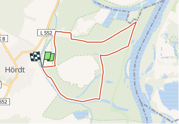
Randonnée A pied de 7,8 km à découvrir à Rhénanie-Palatinat, Landkreis Germersheim, Hördt. Cette randonnée est proposée par SityTrail - itinéraires balisés pédestres.
Description
Es existiert eine weitere Route "Tulpenbaumweg" mit einer Plakette
Symbole: Gelbe Raute
Localisation
Pays :
Allemagne
Région :
Rhénanie-Palatinat
Département/Province :
Landkreis Germersheim
Commune :
Hördt
Localité :
Unknown
Départ:(Dec)
Départ:(UTM)
451606 ; 5446150 (32U) N.
Commentaires
Randonnées à proximité
![Randonnée A pied Germersheim - Rheinaue und Hochgestade - Photo](https://media.geolcdn.com/t/375/260/ext.jpg?maxdim=2&url=https%3A%2F%2Fmedia.geolcdn.com%2Ff%2F12cc67d4-2278-4725-9269-5e991db5c563.jpeg)
![A pied A pied](https://static1.geolcdn.com/sitytour/trail-icons/100.png)
Rheinaue und Hochgestade
A pied
Facile
Germersheim,
Rhénanie-Palatinat,
Landkreis Germersheim,
Allemagne
![](/images/other/stat-length.png)
4,8 km | 5,3 km-effort
1h 12min
![](https://static1.geolcdn.com/siteimages/upload/files/16400158638029165_repeat_loop_refresh_sync_direction_icon.png)
Non
![Randonnée A pied Hördt - Treidlerweg - Photo](https://media.geolcdn.com/t/375/260/ext.jpg?maxdim=2&url=https%3A%2F%2Fmedia.geolcdn.com%2Ff%2F1c56e93e-93d0-491a-b9c8-b0327e11eb3b.jpeg)
![A pied A pied](https://static1.geolcdn.com/sitytour/trail-icons/100.png)
Treidlerweg
A pied
Facile
Hördt,
Rhénanie-Palatinat,
Landkreis Germersheim,
Allemagne
![](/images/other/stat-length.png)
6,6 km | 7,3 km-effort
1h 39min
![](https://static1.geolcdn.com/siteimages/upload/files/16400158638029165_repeat_loop_refresh_sync_direction_icon.png)
Non
![Randonnée Marche Germersheim - Jakobsweg Germersheim-Offenbach - Photo](https://media.geolcdn.com/t/375/260/ext.jpg?maxdim=2&url=https%3A%2F%2Fstatic1.geolcdn.com%2Fsiteimages%2Fupload%2Ffiles%2F1553511878bg_sport_marche.png)
![Marche Marche](https://static1.geolcdn.com/sitytour/trail-icons/101.png)
Jakobsweg Germersheim-Offenbach
Marche
Très difficile
Germersheim,
Rhénanie-Palatinat,
Landkreis Germersheim,
Allemagne
![](/images/other/stat-length.png)
27 km | 29 km-effort
5h 25min
![](https://static1.geolcdn.com/siteimages/upload/files/16400158638029165_repeat_loop_refresh_sync_direction_icon.png)
Non
![Randonnée Marche Germersheim - Vancelle enregistrer - Photo](https://media.geolcdn.com/t/375/260/ext.jpg?maxdim=2&url=https%3A%2F%2Fstatic1.geolcdn.com%2Fsiteimages%2Fupload%2Ffiles%2F1553511878bg_sport_marche.png)
![Marche Marche](https://static1.geolcdn.com/sitytour/trail-icons/101.png)
Vancelle enregistrer
Marche
Très difficile
Germersheim,
Rhénanie-Palatinat,
Landkreis Germersheim,
Allemagne
![](/images/other/stat-length.png)
27 km | 29 km-effort
633h 53min
![](https://static1.geolcdn.com/siteimages/upload/files/16400158638029165_repeat_loop_refresh_sync_direction_icon.png)
Non