![](/images/other/stat-length.png)
![Randonnée A pied Aub - Liebliches Taubertal 26 Zur St. Kunigunde - Photo](https://media.geolcdn.com/t/1900/400/946fdf04-47e8-411e-8959-2837805fe24b.jpeg&format=pjpeg&maxdim=2)
Liebliches Taubertal 26 Zur St. Kunigunde
SityTrail - itinéraires balisés pédestres
Tous les sentiers balisés d’Europe GUIDE+
![Longueur](/images/other/stat-length.png)
Longueur
15,3 km
![Altitude max](https://static1.geolcdn.com/siteimages/upload/files/1508320355ic_sort_altitude_max_24dp.png)
Altitude max
353 m
![Dénivelé positif](https://static1.geolcdn.com/siteimages/upload/files/1508320355ic_sort_den_pos_24dp.png)
Dénivelé positif
211 m
![Km-Effort](/images/other/stat-length.png)
Km-Effort
18,1 km
![Altitude min](https://static1.geolcdn.com/siteimages/upload/files/1508320355ic_sort_altitude_min_24dp.png)
Altitude min
250 m
![Dénivelé négatif](https://static1.geolcdn.com/siteimages/upload/files/1508320355ic_sort_den_neg_24dp.png)
Dénivelé négatif
217 m
![Boucle](https://static1.geolcdn.com/siteimages/upload/files/16400158638029165_repeat_loop_refresh_sync_direction_icon.png)
Boucle
Non
Balise
Date de création :
2022-02-11 19:35:49.102
Dernière modification :
2022-02-11 19:35:49.102
![A pied](https://static1.geolcdn.com/sitytour/trail-icons/100.png)
4h07
Difficulté : Facile
![Scannez ce code QR pour ouvrir la randonnée dans l'application SityTrail](https://capi.geolives.com/qq0zvz2zws4bq2lad0pu/sitytour/trails/3100869/qr.png?size=200)
Application GPS de randonnée GRATUITE
À propos
Randonnée A pied de 15,3 km à découvrir à Bavière, Landkreis Würzburg, Aub. Cette randonnée est proposée par SityTrail - itinéraires balisés pédestres.
Description
Symbole: blaues Schild mit weißer Schrift, in der Mitte durch eine weiße Linie getrennt. Obehalb "LT", darunter "26"
Localisation
Pays :
Allemagne
Région :
Bavière
Département/Province :
Landkreis Würzburg
Commune :
Aub
Localité :
Unknown
Départ:(Dec)
Départ:(UTM)
575476 ; 5487513 (32U) N.
Commentaires
Randonnées à proximité
![Randonnée A pied Röttingen - Liebliches Taubertal 25 Sonnenuhren und Brücken - Photo](https://media.geolcdn.com/t/375/260/4dc51e81-5447-4351-ad0e-60941ddc5e20.jpeg&format=jpg&maxdim=2)
![A pied A pied](https://static1.geolcdn.com/sitytour/trail-icons/100.png)
Liebliches Taubertal 25 Sonnenuhren und Brücken
A pied
Moyen
Röttingen,
Bavière,
Landkreis Würzburg,
Allemagne
![](/images/other/stat-length.png)
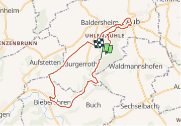
22 km | 28 km-effort
6h 27min
![](https://static1.geolcdn.com/siteimages/upload/files/16400158638029165_repeat_loop_refresh_sync_direction_icon.png)
Non
![Randonnée A pied Bieberehren - Kulturweg Bieberehren 1 - Photo](https://media.geolcdn.com/t/375/260/8f4c942b-b83e-4367-9ab9-eb870987410e.jpeg&format=jpg&maxdim=2)
![A pied A pied](https://static1.geolcdn.com/sitytour/trail-icons/100.png)
Kulturweg Bieberehren 1
A pied
Facile
Bieberehren,
Bavière,
Landkreis Würzburg,
Allemagne
![](/images/other/stat-length.png)
11,8 km | 15,5 km-effort
3h 31min
![](https://static1.geolcdn.com/siteimages/upload/files/16400158638029165_repeat_loop_refresh_sync_direction_icon.png)
Oui