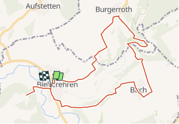
![](/images/other/stat-length.png)
![Randonnée A pied Bieberehren - Kulturweg Bieberehren 1 - Photo](https://media.geolcdn.com/t/1900/400/8f4c942b-b83e-4367-9ab9-eb870987410e.jpeg&format=pjpeg&maxdim=2)
Kulturweg Bieberehren 1
SityTrail - itinéraires balisés pédestres
Tous les sentiers balisés d’Europe GUIDE+
![Longueur](/images/other/stat-length.png)
![Altitude max](https://static1.geolcdn.com/siteimages/upload/files/1508320355ic_sort_altitude_max_24dp.png)
![Dénivelé positif](https://static1.geolcdn.com/siteimages/upload/files/1508320355ic_sort_den_pos_24dp.png)
![Km-Effort](/images/other/stat-length.png)
![Altitude min](https://static1.geolcdn.com/siteimages/upload/files/1508320355ic_sort_altitude_min_24dp.png)
![Dénivelé négatif](https://static1.geolcdn.com/siteimages/upload/files/1508320355ic_sort_den_neg_24dp.png)
![Boucle](https://static1.geolcdn.com/siteimages/upload/files/16400158638029165_repeat_loop_refresh_sync_direction_icon.png)
![A pied](https://static1.geolcdn.com/sitytour/trail-icons/100.png)
3h31
Difficulté : Facile
![Scannez ce code QR pour ouvrir la randonnée dans l'application SityTrail](https://capi.geolives.com/qq0zvz2zws4bq2lad0pu/sitytour/trails/3100867/qr.png?size=200)
Application GPS de randonnée GRATUITE
À propos
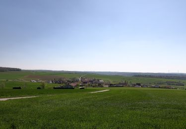
Randonnée A pied de 11,8 km à découvrir à Bavière, Landkreis Würzburg, Bieberehren. Cette randonnée est proposée par SityTrail - itinéraires balisés pédestres.
Description
Randonnée créée par Archäologisches Spessartprojekt.
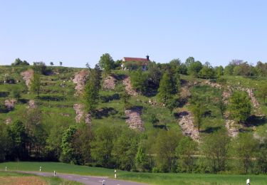
Zwischen Käppele und Kunigundenkapelle lernen Sie spannende Seiten des Bieberehrener BilderBuchs kennen
Symbole: ECPflag.jpg
Site web: http://www.spessartprojekt.de/?page_id=22630
Localisation
Commentaires
Randonnées à proximité
![Randonnée A pied Aub - Liebliches Taubertal 26 Zur St. Kunigunde - Photo](https://media.geolcdn.com/t/375/260/946fdf04-47e8-411e-8959-2837805fe24b.jpeg&format=jpg&maxdim=2)
![A pied A pied](https://static1.geolcdn.com/sitytour/trail-icons/100.png)
A pied
![](/images/other/stat-length.png)
![](https://static1.geolcdn.com/siteimages/upload/files/16400158638029165_repeat_loop_refresh_sync_direction_icon.png)
![Randonnée A pied Röttingen - Liebliches Taubertal 25 Sonnenuhren und Brücken - Photo](https://media.geolcdn.com/t/375/260/4dc51e81-5447-4351-ad0e-60941ddc5e20.jpeg&format=jpg&maxdim=2)
![A pied A pied](https://static1.geolcdn.com/sitytour/trail-icons/100.png)
A pied
![](/images/other/stat-length.png)
![](https://static1.geolcdn.com/siteimages/upload/files/16400158638029165_repeat_loop_refresh_sync_direction_icon.png)