Randonnée A pied Rimsting - Chiemsee Rundweg - Photo

Tous les sentiers balisés d’Europe PRO

© OpenStreetMap contributors
Longueur
Longueur
58 km
Altitude max
Altitude max
599 m
Dénivelé positif
Dénivelé positif
570 m
Km-Effort
Km-Effort  
66 km
Altitude min
Altitude min
514 m
Dénivelé négatif
Dénivelé négatif
577 m
Boucle
Boucle
Oui
Balise
Balise
Date de création :
2022-02-11 19:23:24.163
Dernière modification :
2022-02-11 19:23:24.163

(0 Avis)

A pied
A pied
14h57
Difficulté : Très difficile

Scannez ce code QR pour ouvrir la randonnée dans l'application SityTrail

Application GPS de randonnée GRATUITE

Logo SityTrail SityTrail

IGN / Instituts géographiques

Télécharger SityTrail sur l'App Store Télécharger SityTrail sur Google Play

Logo SityTrail SityTrail World

Le monde est à vous

Télécharger SityTrail sur l'App Store Télécharger SityTrail sur Google Play Télécharger SityTrail sur Huawei AppGallery

À propos

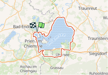
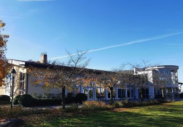
Randonnée A pied de 58 km à découvrir à Bavière, Landkreis Rosenheim, Rimsting. Cette randonnée est proposée par SityTrail - itinéraires balisés pédestres.

Description

Kopie des Radwegs "Chiemsee Rundweg"

Symbole: Runde Schilder mit Chiemsee im Hintergrund, grünem Rahmen und Abbildung eines Fußgängers und Radfahrers

Photos

Localisation

Pays :
Allemagne
Région :
Bavière
Département/Province :
Landkreis Rosenheim
Commune :
Rimsting
Localité :
Unknown
Départ:(UTM)
303048 ; 5307381 (33T) N.

Randonnées à proximité

Randonnée A pied Prien am Chiemsee - Rundweg 1 - Photo
A pied
PRO

A pied

Facile
Prien am Chiemsee, Bavière, Landkreis Rosenheim, Allemagne
3,9 km | 5,4 km-effort
1h 13min
Oui
Randonnée A pied Chiemsee - Rundweg - Tour 1 - Photo
A pied
PRO

A pied

Facile
Chiemsee, Bavière, Landkreis Rosenheim, Allemagne
4 km | 4,6 km-effort
1h 3min
Oui
Randonnée A pied Chiemsee - Rundweg - Tour 2 - Photo
A pied
PRO

A pied

Facile
Chiemsee, Bavière, Landkreis Rosenheim, Allemagne
4,7 km | 5,6 km-effort
1h 15min
Oui
Randonnée A pied Bad Endorf - Wanderweg 5 - Bad Endorf - Photo
A pied
PRO

A pied

Facile
Bad Endorf, Bavière, Landkreis Rosenheim, Allemagne
3,8 km | 4,7 km-effort
1h 4min
Non
Randonnée A pied Bad Endorf - Wanderweg 9 - Bad Endorf - Photo
A pied
PRO

A pied

Facile
Bad Endorf, Bavière, Landkreis Rosenheim, Allemagne
7,9 km | 9,4 km-effort
2h 8min
Oui
Randonnée A pied Bad Endorf - Wanderweg 7 - Bad Endorf - Stockhamer Rundweg - Photo
A pied
PRO

A pied

Facile
Bad Endorf, Bavière, Landkreis Rosenheim, Allemagne
6 km | 7,2 km-effort
1h 38min
Oui
Randonnée A pied Bad Endorf - Wanderweg 4 - Bad Endorf - Photo
A pied
PRO

A pied

Facile
Bad Endorf, Bavière, Landkreis Rosenheim, Allemagne
6,1 km | 7,7 km-effort
1h 44min
Oui
Randonnée A pied Bad Endorf - Wanderweg 3 - Bad Endorf - Photo
A pied
PRO

A pied

Facile
Bad Endorf, Bavière, Landkreis Rosenheim, Allemagne
4,5 km | 5,7 km-effort
1h 17min
Oui
Randonnée A pied Bad Endorf - Wanderweg 16 - Bad Endorf - Photo
A pied
PRO

A pied

Facile
Bad Endorf, Bavière, Landkreis Rosenheim, Allemagne
5,3 km | 6,5 km-effort
1h 28min
Non


Fermer
Mes abonnements