![](/images/other/stat-length.png)
![Randonnée A pied Korbach - Hessenweg 6, Abschnitt Korbach - Mengeringhausen - Photo](https://media.geolcdn.com/t/1900/400/ext.pjpeg?maxdim=2&url=https%3A%2F%2Fmedia.geolcdn.com%2Ff%2Ffaf81515-2b6f-487a-8528-cbe4d3b952b1.jpeg)
Hessenweg 6, Abschnitt Korbach - Mengeringhausen
SityTrail - itinéraires balisés pédestres
Tous les sentiers balisés d’Europe PRO
![Longueur](/images/other/stat-length.png)
Longueur
16,8 km
![Altitude max](https://static1.geolcdn.com/siteimages/upload/files/1508320355ic_sort_altitude_max_24dp.png)
Altitude max
441 m
![Dénivelé positif](https://static1.geolcdn.com/siteimages/upload/files/1508320355ic_sort_den_pos_24dp.png)
Dénivelé positif
317 m
![Km-Effort](/images/other/stat-length.png)
Km-Effort
21 km
![Altitude min](https://static1.geolcdn.com/siteimages/upload/files/1508320355ic_sort_altitude_min_24dp.png)
Altitude min
248 m
![Dénivelé négatif](https://static1.geolcdn.com/siteimages/upload/files/1508320355ic_sort_den_neg_24dp.png)
Dénivelé négatif
390 m
![Boucle](https://static1.geolcdn.com/siteimages/upload/files/16400158638029165_repeat_loop_refresh_sync_direction_icon.png)
Boucle
Non
Balise
Date de création :
2022-02-11 19:20:37.41
Dernière modification :
2022-02-11 19:20:37.41
![A pied](https://static1.geolcdn.com/sitytour/trail-icons/100.png)
4h50
Difficulté : Moyen
![Scannez ce code QR pour ouvrir la randonnée dans l'application SityTrail](https://capi.geolives.com/qq0zvz2zws4bq2lad0pu/sitytour/trails/3100546/qr.png?size=200)
Application GPS de randonnée GRATUITE
À propos
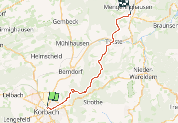
Randonnée A pied de 16,8 km à découvrir à Hesse, Landkreis Waldeck-Frankenberg, Korbach. Cette randonnée est proposée par SityTrail - itinéraires balisés pédestres.
Description
Randonnée créée par Wanderverband Hessen.
Site web: http://www.wanderverband-hessen.de/hessenwege.htm
Localisation
Pays :
Allemagne
Région :
Hesse
Département/Province :
Landkreis Waldeck-Frankenberg
Commune :
Korbach
Localité :
Korbach
Départ:(Dec)
Départ:(UTM)
491159 ; 5680770 (32U) N.
Commentaires
Randonnées à proximité
![Randonnée A pied Korbach - [Z] GeoPfad Korbach - Photo](https://media.geolcdn.com/t/375/260/ext.jpg?maxdim=2&url=https%3A%2F%2Fstatic1.geolcdn.com%2Fsiteimages%2Fupload%2Ffiles%2F1545311037marcheuse_200dpi.jpg)
![A pied A pied](https://static1.geolcdn.com/sitytour/trail-icons/100.png)
[Z] GeoPfad Korbach
A pied
Facile
Korbach,
Hesse,
Landkreis Waldeck-Frankenberg,
Allemagne
![](/images/other/stat-length.png)
9,4 km | 12,4 km-effort
2h 48min
![](https://static1.geolcdn.com/siteimages/upload/files/16400158638029165_repeat_loop_refresh_sync_direction_icon.png)
Non