![](/images/other/stat-length.png)
![Randonnée A pied Waldenbuch - Herzog-Jäger-Pfad Premiumwanderweg - Photo](https://media.geolcdn.com/t/1900/400/96c89033-12cf-4e4b-9db1-7388ac97ce29.jpeg&format=pjpeg&maxdim=2)
Herzog-Jäger-Pfad Premiumwanderweg
SityTrail - itinéraires balisés pédestres
Tous les sentiers balisés d’Europe GUIDE+
![Longueur](/images/other/stat-length.png)
Longueur
13,5 km
![Altitude max](https://static1.geolcdn.com/siteimages/upload/files/1508320355ic_sort_altitude_max_24dp.png)
Altitude max
510 m
![Dénivelé positif](https://static1.geolcdn.com/siteimages/upload/files/1508320355ic_sort_den_pos_24dp.png)
Dénivelé positif
336 m
![Km-Effort](/images/other/stat-length.png)
Km-Effort
18 km
![Altitude min](https://static1.geolcdn.com/siteimages/upload/files/1508320355ic_sort_altitude_min_24dp.png)
Altitude min
364 m
![Dénivelé négatif](https://static1.geolcdn.com/siteimages/upload/files/1508320355ic_sort_den_neg_24dp.png)
Dénivelé négatif
336 m
![Boucle](https://static1.geolcdn.com/siteimages/upload/files/16400158638029165_repeat_loop_refresh_sync_direction_icon.png)
Boucle
Oui
Balise
Date de création :
2022-02-11 19:15:55.023
Dernière modification :
2022-02-11 19:15:55.023
![A pied](https://static1.geolcdn.com/sitytour/trail-icons/100.png)
4h04
Difficulté : Facile
![Scannez ce code QR pour ouvrir la randonnée dans l'application SityTrail](https://capi.geolives.com/qq0zvz2zws4bq2lad0pu/sitytour/trails/3100450/qr.png?size=200)
Application GPS de randonnée GRATUITE
À propos
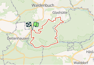
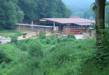
Randonnée A pied de 13,5 km à découvrir à Bade-Wurtemberg, Landkreis Böblingen, Waldenbuch. Cette randonnée est proposée par SityTrail - itinéraires balisés pédestres.
Description
Randonnée créée par Stadt Waldenbuch.
Symbole: Stilisierte Krone auf weißem Hintergrund
Site web: http://www.herzog-jaeger-pfad.de
Localisation
Pays :
Allemagne
Région :
Bade-Wurtemberg
Département/Province :
Landkreis Böblingen
Commune :
Waldenbuch
Localité :
Unknown
Départ:(Dec)
Départ:(UTM)
508662 ; 5384730 (32U) N.
Commentaires
Randonnées à proximité
![Randonnée A pied Weil im Schönbuch - DE-SAV Blauer Punkt Dettenhausen - Bei der Rauhmühle - Photo](https://media.geolcdn.com/t/375/260/aeb9da4c-d640-40fb-8526-a840753989c5.jpeg&format=jpg&maxdim=2)
![A pied A pied](https://static1.geolcdn.com/sitytour/trail-icons/100.png)
DE-SAV Blauer Punkt Dettenhausen - Bei der Rauhmühle
A pied
Facile
Weil im Schönbuch,
Bade-Wurtemberg,
Landkreis Böblingen,
Allemagne
![](/images/other/stat-length.png)
3,5 km | 4,9 km-effort
1h 6min
![](https://static1.geolcdn.com/siteimages/upload/files/16400158638029165_repeat_loop_refresh_sync_direction_icon.png)
Non
![Randonnée A pied Waldenbuch - DE-SAV Roter Punkt Segelbachtal - ? - Photo](https://media.geolcdn.com/t/375/260/e2c0efb9-f5ad-4b7f-a898-40c25222d3f8.jpeg&format=jpg&maxdim=2)
![A pied A pied](https://static1.geolcdn.com/sitytour/trail-icons/100.png)
DE-SAV Roter Punkt Segelbachtal - ?
A pied
Facile
Waldenbuch,
Bade-Wurtemberg,
Landkreis Böblingen,
Allemagne
![](/images/other/stat-length.png)
3 km | 3,8 km-effort
52min
![](https://static1.geolcdn.com/siteimages/upload/files/16400158638029165_repeat_loop_refresh_sync_direction_icon.png)
Non
![Randonnée A pied Waldenbuch - DE-SAV Roter Punkt, Neuenhaus - Burkhardtsmühle - Photo](https://media.geolcdn.com/t/375/260/c7df97bf-21d4-44da-b560-ce8b1847f49a.jpeg&format=jpg&maxdim=2)
![A pied A pied](https://static1.geolcdn.com/sitytour/trail-icons/100.png)
DE-SAV Roter Punkt, Neuenhaus - Burkhardtsmühle
A pied
Facile
Waldenbuch,
Bade-Wurtemberg,
Landkreis Böblingen,
Allemagne
![](/images/other/stat-length.png)
3,4 km | 4,3 km-effort
58min
![](https://static1.geolcdn.com/siteimages/upload/files/16400158638029165_repeat_loop_refresh_sync_direction_icon.png)
Non
![Randonnée A pied Tübingen - DE-SAV Blauer Balken, Bebenhausen - Oberaichen - Photo](https://media.geolcdn.com/t/375/260/a9451fc6-3ee0-46be-896a-e2f985a779c6.jpeg&format=jpg&maxdim=2)
![A pied A pied](https://static1.geolcdn.com/sitytour/trail-icons/100.png)
DE-SAV Blauer Balken, Bebenhausen - Oberaichen
A pied
Facile
Tübingen,
Bade-Wurtemberg,
Landkreis Tübingen,
Allemagne
![](/images/other/stat-length.png)
5,3 km | 7 km-effort
1h 35min
![](https://static1.geolcdn.com/siteimages/upload/files/16400158638029165_repeat_loop_refresh_sync_direction_icon.png)
Non