![](/images/other/stat-length.png)
![Randonnée A pied Remagen - [4] Oberwinter Rundwanderweg - Photo](https://media.geolcdn.com/t/1900/400/e27ef9e9-090e-4d77-ab64-ebc2130b65b2.jpeg&format=pjpeg&maxdim=2)
[4] Oberwinter Rundwanderweg
SityTrail - itinéraires balisés pédestres
Tous les sentiers balisés d’Europe GUIDE+
![Longueur](/images/other/stat-length.png)
Longueur
4,9 km
![Altitude max](https://static1.geolcdn.com/siteimages/upload/files/1508320355ic_sort_altitude_max_24dp.png)
Altitude max
245 m
![Dénivelé positif](https://static1.geolcdn.com/siteimages/upload/files/1508320355ic_sort_den_pos_24dp.png)
Dénivelé positif
135 m
![Km-Effort](/images/other/stat-length.png)
Km-Effort
6,7 km
![Altitude min](https://static1.geolcdn.com/siteimages/upload/files/1508320355ic_sort_altitude_min_24dp.png)
Altitude min
108 m
![Dénivelé négatif](https://static1.geolcdn.com/siteimages/upload/files/1508320355ic_sort_den_neg_24dp.png)
Dénivelé négatif
139 m
![Boucle](https://static1.geolcdn.com/siteimages/upload/files/16400158638029165_repeat_loop_refresh_sync_direction_icon.png)
Boucle
Oui
Balise
Date de création :
2022-02-11 19:05:58.488
Dernière modification :
2022-02-11 19:05:58.488
![A pied](https://static1.geolcdn.com/sitytour/trail-icons/100.png)
1h31
Difficulté : Facile
![Scannez ce code QR pour ouvrir la randonnée dans l'application SityTrail](https://capi.geolives.com/qq0zvz2zws4bq2lad0pu/sitytour/trails/3100251/qr.png?size=200)
Application GPS de randonnée GRATUITE
À propos
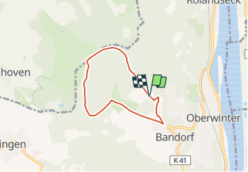
Randonnée A pied de 4,9 km à découvrir à Rhénanie-Palatinat, Landkreis Ahrweiler, Remagen. Cette randonnée est proposée par SityTrail - itinéraires balisés pédestres.
Description
Randonnée créée par Verkehrs- und Verschönerungsverein Oberwinter-Rolandseck e.V..
Symbole: schwarzer "4" auf weißem Grund
Localisation
Pays :
Allemagne
Région :
Rhénanie-Palatinat
Département/Province :
Landkreis Ahrweiler
Commune :
Remagen
Localité :
Unknown
Départ:(Dec)
Départ:(UTM)
372124 ; 5608550 (32U) N.
Commentaires
Randonnées à proximité
![Randonnée A pied Bruchhausen - Rotbäckchen Rundwanderweg - Photo](https://media.geolcdn.com/t/375/260/1dd5c4a7-c3a6-459c-9cef-b7e5315b6005.jpeg&format=jpg&maxdim=2)
![A pied A pied](https://static1.geolcdn.com/sitytour/trail-icons/100.png)
Rotbäckchen Rundwanderweg
A pied
Facile
Bruchhausen,
Rhénanie-Palatinat,
Landkreis Neuwied,
Allemagne
![](/images/other/stat-length.png)
11,1 km | 14,1 km-effort
3h 11min
![](https://static1.geolcdn.com/siteimages/upload/files/16400158638029165_repeat_loop_refresh_sync_direction_icon.png)
Oui
![Randonnée A pied Remagen - Apollinaris-Schleife (Rheinburgenweg Rundtour) - Photo](https://media.geolcdn.com/t/375/260/afe28d54-8362-474d-8d66-b77f50c689dd.jpeg&format=jpg&maxdim=2)
![A pied A pied](https://static1.geolcdn.com/sitytour/trail-icons/100.png)
Apollinaris-Schleife (Rheinburgenweg Rundtour)
A pied
Facile
Remagen,
Rhénanie-Palatinat,
Landkreis Ahrweiler,
Allemagne
![](/images/other/stat-length.png)
12,7 km | 16,4 km-effort
3h 43min
![](https://static1.geolcdn.com/siteimages/upload/files/16400158638029165_repeat_loop_refresh_sync_direction_icon.png)
Oui
![Randonnée A pied Remagen - [5] Oberwinter Rundwanderweg - Photo](https://media.geolcdn.com/t/375/260/f5d36974-2dd7-4709-98b7-1c99706d0ead.jpeg&format=jpg&maxdim=2)
![A pied A pied](https://static1.geolcdn.com/sitytour/trail-icons/100.png)
[5] Oberwinter Rundwanderweg
A pied
Facile
Remagen,
Rhénanie-Palatinat,
Landkreis Ahrweiler,
Allemagne
![](/images/other/stat-length.png)
9,1 km | 13,1 km-effort
2h 58min
![](https://static1.geolcdn.com/siteimages/upload/files/16400158638029165_repeat_loop_refresh_sync_direction_icon.png)
Oui
![Randonnée A pied Remagen - Oberwinter Rundweg 2 - Photo](https://media.geolcdn.com/t/375/260/778735ff-4094-4e3b-aa07-2d8b179e4649.jpeg&format=jpg&maxdim=2)
![A pied A pied](https://static1.geolcdn.com/sitytour/trail-icons/100.png)
Oberwinter Rundweg 2
A pied
Facile
Remagen,
Rhénanie-Palatinat,
Landkreis Ahrweiler,
Allemagne
![](/images/other/stat-length.png)
5,1 km | 6,6 km-effort
1h 29min
![](https://static1.geolcdn.com/siteimages/upload/files/16400158638029165_repeat_loop_refresh_sync_direction_icon.png)
Non
![Randonnée A pied Remagen - [1] Oberwinter Wanderweg (Oberwinter - Rolandseck) - Photo](https://media.geolcdn.com/t/375/260/25784967-1970-4af5-8d60-8f5ed7fdcfe9.jpeg&format=jpg&maxdim=2)
![A pied A pied](https://static1.geolcdn.com/sitytour/trail-icons/100.png)
[1] Oberwinter Wanderweg (Oberwinter - Rolandseck)
A pied
Facile
Remagen,
Rhénanie-Palatinat,
Landkreis Ahrweiler,
Allemagne
![](/images/other/stat-length.png)
3,7 km | 5,2 km-effort
1h 10min
![](https://static1.geolcdn.com/siteimages/upload/files/16400158638029165_repeat_loop_refresh_sync_direction_icon.png)
Non
![Randonnée A pied Wachtberg - Verbindungsweg - Photo](https://media.geolcdn.com/t/375/260/8a894d8e-564e-4043-b18c-669126bb6c29.jpeg&format=jpg&maxdim=2)
![A pied A pied](https://static1.geolcdn.com/sitytour/trail-icons/100.png)
Verbindungsweg
A pied
Facile
Wachtberg,
Rhénanie-du-Nord-Westphalie,
Rhein-Sieg-Kreis,
Allemagne
![](/images/other/stat-length.png)
4,8 km | 6,1 km-effort
1h 22min
![](https://static1.geolcdn.com/siteimages/upload/files/16400158638029165_repeat_loop_refresh_sync_direction_icon.png)
Non
![Randonnée A pied Wachtberg - Dächelsberg-Runde - Photo](https://media.geolcdn.com/t/375/260/c7273de2-5b65-4b43-93d9-f0b5ff3f0a2d.jpeg&format=jpg&maxdim=2)
![A pied A pied](https://static1.geolcdn.com/sitytour/trail-icons/100.png)
Dächelsberg-Runde
A pied
Facile
Wachtberg,
Rhénanie-du-Nord-Westphalie,
Rhein-Sieg-Kreis,
Allemagne
![](/images/other/stat-length.png)
7,2 km | 8,9 km-effort
2h 1min
![](https://static1.geolcdn.com/siteimages/upload/files/16400158638029165_repeat_loop_refresh_sync_direction_icon.png)
Oui
![Randonnée A pied Wachtberg - Hümerich-Runde - Photo](https://media.geolcdn.com/t/375/260/b8080069-04dc-4f64-9b7d-918abc393f6f.jpeg&format=jpg&maxdim=2)
![A pied A pied](https://static1.geolcdn.com/sitytour/trail-icons/100.png)
Hümerich-Runde
A pied
Facile
Wachtberg,
Rhénanie-du-Nord-Westphalie,
Rhein-Sieg-Kreis,
Allemagne
![](/images/other/stat-length.png)
5,9 km | 7,4 km-effort
1h 40min
![](https://static1.geolcdn.com/siteimages/upload/files/16400158638029165_repeat_loop_refresh_sync_direction_icon.png)
Oui
![Randonnée A pied Bad Honnef - Rheinsteig-Zuweg Bad Honnef (Nord) - Photo](https://media.geolcdn.com/t/375/260/e60109cf-63fe-45d6-8fb4-6ccf1e16ec85.jpeg&format=jpg&maxdim=2)
![A pied A pied](https://static1.geolcdn.com/sitytour/trail-icons/100.png)
Rheinsteig-Zuweg Bad Honnef (Nord)
A pied
Facile
Bad Honnef,
Rhénanie-du-Nord-Westphalie,
Rhein-Sieg-Kreis,
Allemagne
![](/images/other/stat-length.png)
4,2 km | 7 km-effort
1h 34min
![](https://static1.geolcdn.com/siteimages/upload/files/16400158638029165_repeat_loop_refresh_sync_direction_icon.png)
Non