![](/images/other/stat-length.png)
![Randonnée A pied Simmersfeld - 7 Mühlen Pfad - Photo](https://media.geolcdn.com/t/1900/400/ext.pjpeg?maxdim=2&url=https%3A%2F%2Fstatic1.geolcdn.com%2Fsiteimages%2Fupload%2Ffiles%2F1545311037marcheuse_200dpi.jpg)
7 Mühlen Pfad
SityTrail - itinéraires balisés pédestres
Tous les sentiers balisés d’Europe GUIDE+
![Longueur](/images/other/stat-length.png)
Longueur
6,5 km
![Altitude max](https://static1.geolcdn.com/siteimages/upload/files/1508320355ic_sort_altitude_max_24dp.png)
Altitude max
627 m
![Dénivelé positif](https://static1.geolcdn.com/siteimages/upload/files/1508320355ic_sort_den_pos_24dp.png)
Dénivelé positif
156 m
![Km-Effort](/images/other/stat-length.png)
Km-Effort
8,6 km
![Altitude min](https://static1.geolcdn.com/siteimages/upload/files/1508320355ic_sort_altitude_min_24dp.png)
Altitude min
501 m
![Dénivelé négatif](https://static1.geolcdn.com/siteimages/upload/files/1508320355ic_sort_den_neg_24dp.png)
Dénivelé négatif
163 m
![Boucle](https://static1.geolcdn.com/siteimages/upload/files/16400158638029165_repeat_loop_refresh_sync_direction_icon.png)
Boucle
Oui
Balise
Date de création :
2022-02-11 19:05:36.968
Dernière modification :
2022-02-11 19:05:36.968
![A pied](https://static1.geolcdn.com/sitytour/trail-icons/100.png)
1h56
Difficulté : Facile
![Scannez ce code QR pour ouvrir la randonnée dans l'application SityTrail](https://capi.geolives.com/qq0zvz2zws4bq2lad0pu/sitytour/trails/3100243/qr.png?size=200)
Application GPS de randonnée GRATUITE
À propos
Randonnée A pied de 6,5 km à découvrir à Bade-Wurtemberg, Landkreis Calw, Simmersfeld. Cette randonnée est proposée par SityTrail - itinéraires balisés pédestres.
Description
(fast?) vollständig
Site web: http://www.simmersfeld.de/freizeit/wanderungen-rundwanderung-siebenmühlen-pfad.html
Localisation
Pays :
Allemagne
Région :
Bade-Wurtemberg
Département/Province :
Landkreis Calw
Commune :
Simmersfeld
Localité :
Unknown
Départ:(Dec)
Départ:(UTM)
464572 ; 5384208 (32U) N.
Commentaires
Randonnées à proximité
![Randonnée A pied Seewald - Hochdorf Sägemühle-Winterhalde - Photo](https://media.geolcdn.com/t/375/260/65d5726f-6113-429c-943a-8418fa850a15.jpeg&format=jpg&maxdim=2)
![A pied A pied](https://static1.geolcdn.com/sitytour/trail-icons/100.png)
Hochdorf Sägemühle-Winterhalde
A pied
Facile
Seewald,
Bade-Wurtemberg,
Landkreis Freudenstadt,
Allemagne
![](/images/other/stat-length.png)
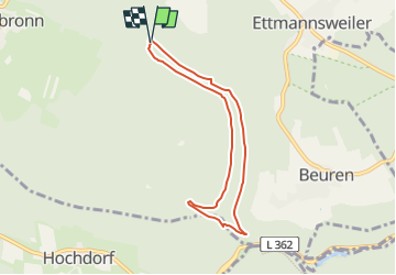
10,3 km | 14,8 km-effort
3h 21min
![](https://static1.geolcdn.com/siteimages/upload/files/16400158638029165_repeat_loop_refresh_sync_direction_icon.png)
Non
![Randonnée A pied Simmersfeld - Hofmühle-Simmersfeld Dieselstraße - Photo](https://media.geolcdn.com/t/375/260/649e96b1-b7f1-4717-842f-8270441ae791.jpeg&format=jpg&maxdim=2)
![A pied A pied](https://static1.geolcdn.com/sitytour/trail-icons/100.png)
Hofmühle-Simmersfeld Dieselstraße
A pied
Facile
Simmersfeld,
Bade-Wurtemberg,
Landkreis Calw,
Allemagne
![](/images/other/stat-length.png)
4,8 km | 6,6 km-effort
1h 30min
![](https://static1.geolcdn.com/siteimages/upload/files/16400158638029165_repeat_loop_refresh_sync_direction_icon.png)
Non
![Randonnée A pied Seewald - Göttelfingen-Besenfeld - Photo](https://media.geolcdn.com/t/375/260/de1a7f41-2ac6-4cc8-8bab-4801b8a7ca57.jpeg&format=jpg&maxdim=2)
![A pied A pied](https://static1.geolcdn.com/sitytour/trail-icons/100.png)
Göttelfingen-Besenfeld
A pied
Facile
Seewald,
Bade-Wurtemberg,
Landkreis Freudenstadt,
Allemagne
![](/images/other/stat-length.png)
5,2 km | 7,8 km-effort
1h 46min
![](https://static1.geolcdn.com/siteimages/upload/files/16400158638029165_repeat_loop_refresh_sync_direction_icon.png)
Non
![Randonnée A pied Grömbach - Nagoldtal - Simmersfeld - Photo](https://media.geolcdn.com/t/375/260/649e96b1-b7f1-4717-842f-8270441ae791.jpeg&format=jpg&maxdim=2)
![A pied A pied](https://static1.geolcdn.com/sitytour/trail-icons/100.png)
Nagoldtal - Simmersfeld
A pied
Facile
Grömbach,
Bade-Wurtemberg,
Landkreis Freudenstadt,
Allemagne
![](/images/other/stat-length.png)
5,6 km | 8,5 km-effort
1h 55min
![](https://static1.geolcdn.com/siteimages/upload/files/16400158638029165_repeat_loop_refresh_sync_direction_icon.png)
Non
![Randonnée A pied Simmersfeld - Aichhalden - Gaugenwald - Photo](https://media.geolcdn.com/t/375/260/b4159829-2294-4269-9b7c-3662bc9a02cd.jpeg&format=jpg&maxdim=2)
![A pied A pied](https://static1.geolcdn.com/sitytour/trail-icons/100.png)
Aichhalden - Gaugenwald
A pied
Facile
Simmersfeld,
Bade-Wurtemberg,
Landkreis Calw,
Allemagne
![](/images/other/stat-length.png)
7,4 km | 9,2 km-effort
2h 4min
![](https://static1.geolcdn.com/siteimages/upload/files/16400158638029165_repeat_loop_refresh_sync_direction_icon.png)
Non
![Randonnée A pied Simmersfeld - Ettmannsweiler Marktgasse-Beurener Berg - Photo](https://media.geolcdn.com/t/375/260/395f3fd8-0125-4dc2-8ce9-386e21aa19a7.jpeg&format=jpg&maxdim=2)
![A pied A pied](https://static1.geolcdn.com/sitytour/trail-icons/100.png)
Ettmannsweiler Marktgasse-Beurener Berg
A pied
Facile
Simmersfeld,
Bade-Wurtemberg,
Landkreis Calw,
Allemagne
![](/images/other/stat-length.png)
4,2 km | 5,1 km-effort
1h 10min
![](https://static1.geolcdn.com/siteimages/upload/files/16400158638029165_repeat_loop_refresh_sync_direction_icon.png)
Non
![Randonnée A pied Grömbach - Pfaffenstube-Göttelfingen - Photo](https://media.geolcdn.com/t/375/260/e4f87211-24c7-4a0e-a2b2-3a01b0eae8bb.jpeg&format=jpg&maxdim=2)
![A pied A pied](https://static1.geolcdn.com/sitytour/trail-icons/100.png)
Pfaffenstube-Göttelfingen
A pied
Facile
Grömbach,
Bade-Wurtemberg,
Landkreis Freudenstadt,
Allemagne
![](/images/other/stat-length.png)
3,3 km | 6,1 km-effort
1h 23min
![](https://static1.geolcdn.com/siteimages/upload/files/16400158638029165_repeat_loop_refresh_sync_direction_icon.png)
Non
![Randonnée A pied Altensteig - Spielberg Rundweg 5 - Photo](https://media.geolcdn.com/t/375/260/ext.jpg?maxdim=2&url=https%3A%2F%2Fstatic1.geolcdn.com%2Fsiteimages%2Fupload%2Ffiles%2F1545311037marcheuse_200dpi.jpg)
![A pied A pied](https://static1.geolcdn.com/sitytour/trail-icons/100.png)
Spielberg Rundweg 5
A pied
Facile
Altensteig,
Bade-Wurtemberg,
Landkreis Calw,
Allemagne
![](/images/other/stat-length.png)
4,3 km | 5,6 km-effort
1h 16min
![](https://static1.geolcdn.com/siteimages/upload/files/16400158638029165_repeat_loop_refresh_sync_direction_icon.png)
Non
![Randonnée A pied Seewald - Bussenwiesen See-Kropfmühle - Photo](https://media.geolcdn.com/t/375/260/ext.jpg?maxdim=2&url=https%3A%2F%2Fstatic1.geolcdn.com%2Fsiteimages%2Fupload%2Ffiles%2F1545311037marcheuse_200dpi.jpg)
![A pied A pied](https://static1.geolcdn.com/sitytour/trail-icons/100.png)
Bussenwiesen See-Kropfmühle
A pied
Facile
Seewald,
Bade-Wurtemberg,
Landkreis Freudenstadt,
Allemagne
![](/images/other/stat-length.png)
3,8 km | 4,6 km-effort
1h 2min
![](https://static1.geolcdn.com/siteimages/upload/files/16400158638029165_repeat_loop_refresh_sync_direction_icon.png)
Non