![](/images/other/stat-length.png)
![Randonnée A pied Inconnu - Rundwanderweg Erzhausen - Photo](https://media.geolcdn.com/t/1900/400/0d3571f9-ed3d-4b4e-9855-eba80a245c87.jpeg&format=pjpeg&maxdim=2)
Rundwanderweg Erzhausen
SityTrail - itinéraires balisés pédestres
Tous les sentiers balisés d’Europe GUIDE+
![Longueur](/images/other/stat-length.png)
![Altitude max](https://static1.geolcdn.com/siteimages/upload/files/1508320355ic_sort_altitude_max_24dp.png)
![Dénivelé positif](https://static1.geolcdn.com/siteimages/upload/files/1508320355ic_sort_den_pos_24dp.png)
![Km-Effort](/images/other/stat-length.png)
![Altitude min](https://static1.geolcdn.com/siteimages/upload/files/1508320355ic_sort_altitude_min_24dp.png)
![Dénivelé négatif](https://static1.geolcdn.com/siteimages/upload/files/1508320355ic_sort_den_neg_24dp.png)
![Boucle](https://static1.geolcdn.com/siteimages/upload/files/16400158638029165_repeat_loop_refresh_sync_direction_icon.png)
![A pied](https://static1.geolcdn.com/sitytour/trail-icons/100.png)
2h49
Difficulté : Facile
![Scannez ce code QR pour ouvrir la randonnée dans l'application SityTrail](https://capi.geolives.com/qq0zvz2zws4bq2lad0pu/sitytour/trails/3100092/qr.png?size=200)
Application GPS de randonnée GRATUITE
À propos
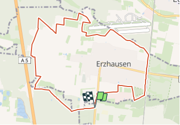
Randonnée A pied de 11,2 km à découvrir à Hesse, Darmstadt, Inconnu. Cette randonnée est proposée par SityTrail - itinéraires balisés pédestres.
Description
Initiative des Ortskundlichen Arbeitskreises Erzhausen in Zusammenarbeit mit dem Obst- und Gartenbauverein, den Naturfreunden Egelsbach-Erzhausen und mit "WIR-in-Erzhausen" ; am 9. Juni 2018 im Rahmen des Erzhäuser Gemarkungsrundgangs offiziell eingeweiht
Localisation
Commentaires
Randonnées à proximité
![Randonnée A pied Inconnu - Rundwanderweg Darmstadt Am Forschungszentrum 9: Dianaburg-Weg - Photo](https://media.geolcdn.com/t/375/260/e7522232-749b-4e49-ab54-12744d65b4a1.jpeg&format=jpg&maxdim=2)
![A pied A pied](https://static1.geolcdn.com/sitytour/trail-icons/100.png)
A pied
![](/images/other/stat-length.png)
![](https://static1.geolcdn.com/siteimages/upload/files/16400158638029165_repeat_loop_refresh_sync_direction_icon.png)
![Randonnée A pied Inconnu - Weiterstädter Rundwanderwege WRW - Photo](https://media.geolcdn.com/t/375/260/74c83b76-3f1a-4870-ba4d-624750463607.jpeg&format=jpg&maxdim=2)
![A pied A pied](https://static1.geolcdn.com/sitytour/trail-icons/100.png)
A pied
![](/images/other/stat-length.png)
![](https://static1.geolcdn.com/siteimages/upload/files/16400158638029165_repeat_loop_refresh_sync_direction_icon.png)
![Randonnée A pied Weiterstadt - Weiterstädter Rundwanderwege - Stadtteilrunde Braunshardt - Photo](https://media.geolcdn.com/t/375/260/6e640f51-5d4c-4a37-8e9e-a0aff99ff21b.jpeg&format=jpg&maxdim=2)
![A pied A pied](https://static1.geolcdn.com/sitytour/trail-icons/100.png)
A pied
![](/images/other/stat-length.png)
![](https://static1.geolcdn.com/siteimages/upload/files/16400158638029165_repeat_loop_refresh_sync_direction_icon.png)
![Randonnée A pied Weiterstadt - Weiterstädter Rundwanderwege - Stadtteilrunde Gräfenhausen - Photo](https://media.geolcdn.com/t/375/260/ad71f7b7-4907-45b1-b6c1-3c6f157377d3.jpeg&format=jpg&maxdim=2)
![A pied A pied](https://static1.geolcdn.com/sitytour/trail-icons/100.png)
A pied
![](/images/other/stat-length.png)
![](https://static1.geolcdn.com/siteimages/upload/files/16400158638029165_repeat_loop_refresh_sync_direction_icon.png)
![Randonnée A pied Inconnu - Weiterstädter Rundwanderwege - Stadtteilrunde Riedbahn - Photo](https://media.geolcdn.com/t/375/260/74c83b76-3f1a-4870-ba4d-624750463607.jpeg&format=jpg&maxdim=2)
![A pied A pied](https://static1.geolcdn.com/sitytour/trail-icons/100.png)
A pied
![](/images/other/stat-length.png)
![](https://static1.geolcdn.com/siteimages/upload/files/16400158638029165_repeat_loop_refresh_sync_direction_icon.png)
![Randonnée A pied Inconnu - Rundwanderweg Darmstadt Jagdschl. Kranichstein 5: Dianaburg-Weg - Photo](https://media.geolcdn.com/t/375/260/fa24b1c5-f5f1-409a-a4a2-17576f6d5dfa.jpeg&format=jpg&maxdim=2)
![A pied A pied](https://static1.geolcdn.com/sitytour/trail-icons/100.png)
A pied
![](/images/other/stat-length.png)
![](https://static1.geolcdn.com/siteimages/upload/files/16400158638029165_repeat_loop_refresh_sync_direction_icon.png)
![Randonnée A pied Inconnu - Rundwanderweg Darmstadt Jagdschl. Kranichstein 6: Falkenhof-Weg - Photo](https://media.geolcdn.com/t/375/260/8e7ef7dc-a73a-4ee0-8455-50c6924322d1.jpeg&format=jpg&maxdim=2)
![A pied A pied](https://static1.geolcdn.com/sitytour/trail-icons/100.png)
A pied
![](/images/other/stat-length.png)
![](https://static1.geolcdn.com/siteimages/upload/files/16400158638029165_repeat_loop_refresh_sync_direction_icon.png)
![Randonnée A pied Weiterstadt - Weiterstädter Rundwanderwege - Stadtteilrunde Schneppenhausen - Photo](https://media.geolcdn.com/t/375/260/ad71f7b7-4907-45b1-b6c1-3c6f157377d3.jpeg&format=jpg&maxdim=2)
![A pied A pied](https://static1.geolcdn.com/sitytour/trail-icons/100.png)
A pied
![](/images/other/stat-length.png)
![](https://static1.geolcdn.com/siteimages/upload/files/16400158638029165_repeat_loop_refresh_sync_direction_icon.png)
![Randonnée A pied Mörfelden-Walldorf - Hugenotten- und Waldenserpfad (Abschnitt Erzhausen - Mörfelden-Walldorf) - Photo](https://media.geolcdn.com/t/375/260/ext.jpg?maxdim=2&url=https%3A%2F%2Fstatic1.geolcdn.com%2Fsiteimages%2Fupload%2Ffiles%2F1545311037marcheuse_200dpi.jpg)
![A pied A pied](https://static1.geolcdn.com/sitytour/trail-icons/100.png)
A pied
![](/images/other/stat-length.png)
![](https://static1.geolcdn.com/siteimages/upload/files/16400158638029165_repeat_loop_refresh_sync_direction_icon.png)