![](/images/other/stat-length.png)
![Randonnée A pied Külsheim - Liebliches Taubertal - Photo](https://media.geolcdn.com/t/1900/400/a4aac17d-803e-4ec5-a967-c70042af1b40.jpeg&format=pjpeg&maxdim=2)
Liebliches Taubertal
SityTrail - itinéraires balisés pédestres
Tous les sentiers balisés d’Europe GUIDE+
![Longueur](/images/other/stat-length.png)
![Altitude max](https://static1.geolcdn.com/siteimages/upload/files/1508320355ic_sort_altitude_max_24dp.png)
![Dénivelé positif](https://static1.geolcdn.com/siteimages/upload/files/1508320355ic_sort_den_pos_24dp.png)
![Km-Effort](/images/other/stat-length.png)
![Altitude min](https://static1.geolcdn.com/siteimages/upload/files/1508320355ic_sort_altitude_min_24dp.png)
![Dénivelé négatif](https://static1.geolcdn.com/siteimages/upload/files/1508320355ic_sort_den_neg_24dp.png)
![Boucle](https://static1.geolcdn.com/siteimages/upload/files/16400158638029165_repeat_loop_refresh_sync_direction_icon.png)
![A pied](https://static1.geolcdn.com/sitytour/trail-icons/100.png)
6h08
Difficulté : Moyen
![Scannez ce code QR pour ouvrir la randonnée dans l'application SityTrail](https://capi.geolives.com/qq0zvz2zws4bq2lad0pu/sitytour/trails/3099871/qr.png?size=200)
Application GPS de randonnée GRATUITE
À propos
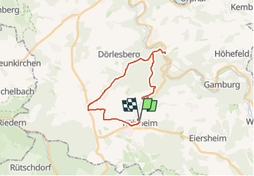
Randonnée A pied de 21 km à découvrir à Bade-Wurtemberg, Main-Tauber-Kreis, Külsheim. Cette randonnée est proposée par SityTrail - itinéraires balisés pédestres.
Description
Randonnée créée par Tourismusverband „Liebliches Taubertal“.
Symbole: weißes LT 4 auf blauen Grund
Site web: https://www.liebliches-taubertal.de/Aktiv/Wandern/Rundwanderungen/Wanderung-Nr-4-Schoenert.html
Localisation
Commentaires
Randonnées à proximité
![Randonnée A pied Wertheim - Kulturweg Bronnbach Höhefeld - Photo](https://media.geolcdn.com/t/375/260/d419287f-d06a-4f1a-8bf9-699abcc1ffba.jpeg&format=jpg&maxdim=2)
![A pied A pied](https://static1.geolcdn.com/sitytour/trail-icons/100.png)
A pied
![](/images/other/stat-length.png)
![](https://static1.geolcdn.com/siteimages/upload/files/16400158638029165_repeat_loop_refresh_sync_direction_icon.png)
![Randonnée A pied Werbach - Rundwanderweg Gamburg 6 - Photo](https://media.geolcdn.com/t/375/260/83afd43d-bbd6-4c00-a4de-95dd32ba431b.jpeg&format=jpg&maxdim=2)
![A pied A pied](https://static1.geolcdn.com/sitytour/trail-icons/100.png)
A pied
![](/images/other/stat-length.png)
![](https://static1.geolcdn.com/siteimages/upload/files/16400158638029165_repeat_loop_refresh_sync_direction_icon.png)
![Randonnée A pied Werbach - Rundwanderweg Gamburg 4 - Photo](https://media.geolcdn.com/t/375/260/83afd43d-bbd6-4c00-a4de-95dd32ba431b.jpeg&format=jpg&maxdim=2)
![A pied A pied](https://static1.geolcdn.com/sitytour/trail-icons/100.png)
A pied
![](/images/other/stat-length.png)
![](https://static1.geolcdn.com/siteimages/upload/files/16400158638029165_repeat_loop_refresh_sync_direction_icon.png)