![](/images/other/stat-length.png)
![Randonnée A pied Moosbach - Moosbach - Rundwanderweg 3 - Photo](https://media.geolcdn.com/t/1900/400/6f6732bf-bd68-4869-a269-3a67fd8aa48b.jpeg&format=pjpeg&maxdim=2)
Moosbach - Rundwanderweg 3
SityTrail - itinéraires balisés pédestres
Tous les sentiers balisés d’Europe GUIDE+
![Longueur](/images/other/stat-length.png)
Longueur
9,9 km
![Altitude max](https://static1.geolcdn.com/siteimages/upload/files/1508320355ic_sort_altitude_max_24dp.png)
Altitude max
653 m
![Dénivelé positif](https://static1.geolcdn.com/siteimages/upload/files/1508320355ic_sort_den_pos_24dp.png)
Dénivelé positif
219 m
![Km-Effort](/images/other/stat-length.png)
Km-Effort
12,8 km
![Altitude min](https://static1.geolcdn.com/siteimages/upload/files/1508320355ic_sort_altitude_min_24dp.png)
Altitude min
483 m
![Dénivelé négatif](https://static1.geolcdn.com/siteimages/upload/files/1508320355ic_sort_den_neg_24dp.png)
Dénivelé négatif
218 m
![Boucle](https://static1.geolcdn.com/siteimages/upload/files/16400158638029165_repeat_loop_refresh_sync_direction_icon.png)
Boucle
Oui
Balise
Date de création :
2022-02-11 18:36:26.565
Dernière modification :
2022-02-11 18:36:26.565
![A pied](https://static1.geolcdn.com/sitytour/trail-icons/100.png)
2h54
Difficulté : Facile
![Scannez ce code QR pour ouvrir la randonnée dans l'application SityTrail](https://capi.geolives.com/qq0zvz2zws4bq2lad0pu/sitytour/trails/3099683/qr.png?size=200)
Application GPS de randonnée GRATUITE
À propos
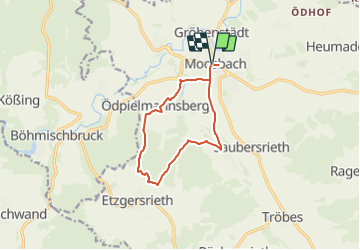
Randonnée A pied de 9,9 km à découvrir à Bavière, Landkreis Neustadt an der Waldnaab, Moosbach. Cette randonnée est proposée par SityTrail - itinéraires balisés pédestres.
Description
Randonnée créée par Oberpfälzer Waldverein.
Symbole: blue 3 on white background
Localisation
Pays :
Allemagne
Région :
Bavière
Département/Province :
Landkreis Neustadt an der Waldnaab
Commune :
Moosbach
Localité :
Unknown
Départ:(Dec)
Départ:(UTM)
312616 ; 5496438 (33U) N.
Commentaires
Randonnées à proximité
![Randonnée A pied Hošťka - Vyhlídková naučná stezka - Photo](https://media.geolcdn.com/t/375/260/de5fa688-c472-4e93-ac35-43eb0e649d0c.jpeg&format=jpg&maxdim=2)
![A pied A pied](https://static1.geolcdn.com/sitytour/trail-icons/100.png)
Vyhlídková naučná stezka
A pied
Facile
Hošťka,
Jihozápad,
Plzeňský kraj,
République Tchèque
![](/images/other/stat-length.png)
13,6 km | 16,8 km-effort
3h 48min
![](https://static1.geolcdn.com/siteimages/upload/files/16400158638029165_repeat_loop_refresh_sync_direction_icon.png)
Oui
![Randonnée A pied Přimda - naučná stezka Přimda - Photo](https://media.geolcdn.com/t/375/260/e1e6d3f2-fe9e-4d62-8210-f9dffe466772.jpeg&format=jpg&maxdim=2)
![A pied A pied](https://static1.geolcdn.com/sitytour/trail-icons/100.png)
naučná stezka Přimda
A pied
Facile
Přimda,
Jihozápad,
Plzeňský kraj,
République Tchèque
![](/images/other/stat-length.png)
7,7 km | 11,3 km-effort
2h 34min
![](https://static1.geolcdn.com/siteimages/upload/files/16400158638029165_repeat_loop_refresh_sync_direction_icon.png)
Oui
![Randonnée A pied Rybník - [M] Rybník - Rybník CZ/D - Photo](https://media.geolcdn.com/t/375/260/3e72288d-7700-4a27-9695-4c0fe2037764.jpeg&format=jpg&maxdim=2)
![A pied A pied](https://static1.geolcdn.com/sitytour/trail-icons/100.png)
[M] Rybník - Rybník CZ/D
A pied
Facile
Rybník,
Jihozápad,
Plzeňský kraj,
République Tchèque
![](/images/other/stat-length.png)
3,5 km | 4,5 km-effort
1h 1min
![](https://static1.geolcdn.com/siteimages/upload/files/16400158638029165_repeat_loop_refresh_sync_direction_icon.png)
Non
![Randonnée A pied Rozvadov - [M] Okružní naučná stezka Kolowratova - Photo](https://media.geolcdn.com/t/375/260/48bd39eb-9e5f-4fa1-b21c-b0525a6f7f06.jpeg&format=jpg&maxdim=2)
![A pied A pied](https://static1.geolcdn.com/sitytour/trail-icons/100.png)
[M] Okružní naučná stezka Kolowratova
A pied
Moyen
Rozvadov,
Jihozápad,
Plzeňský kraj,
République Tchèque
![](/images/other/stat-length.png)
17 km | 20 km-effort
4h 36min
![](https://static1.geolcdn.com/siteimages/upload/files/16400158638029165_repeat_loop_refresh_sync_direction_icon.png)
Oui
![Randonnée A pied Lesná - [Z] naučná stezka historie sklářství - Photo](https://media.geolcdn.com/t/375/260/4bc902d5-239d-46bc-9e59-dc21d99fa2b6.jpeg&format=jpg&maxdim=2)
![A pied A pied](https://static1.geolcdn.com/sitytour/trail-icons/100.png)
[Z] naučná stezka historie sklářství
A pied
Facile
Lesná,
Jihozápad,
Plzeňský kraj,
République Tchèque
![](/images/other/stat-length.png)
6,3 km | 8 km-effort
1h 48min
![](https://static1.geolcdn.com/siteimages/upload/files/16400158638029165_repeat_loop_refresh_sync_direction_icon.png)
Oui
![Randonnée A pied Bělá nad Radbuzou - 3 Nepomukweg - Photo](https://media.geolcdn.com/t/375/260/395eeab1-c2f5-43fc-9b14-49cffd2df5f4.jpeg&format=jpg&maxdim=2)
![A pied A pied](https://static1.geolcdn.com/sitytour/trail-icons/100.png)
3 Nepomukweg
A pied
Facile
Bělá nad Radbuzou,
Jihozápad,
Plzeňský kraj,
République Tchèque
![](/images/other/stat-length.png)
3,3 km | 4,2 km-effort
56min
![](https://static1.geolcdn.com/siteimages/upload/files/16400158638029165_repeat_loop_refresh_sync_direction_icon.png)
Non
![Randonnée A pied Lesná - Naučná stezka Lesná - Photo](https://media.geolcdn.com/t/375/260/7ec10752-3463-40c5-924d-1826efcd3eae.jpeg&format=jpg&maxdim=2)
![A pied A pied](https://static1.geolcdn.com/sitytour/trail-icons/100.png)
Naučná stezka Lesná
A pied
Facile
Lesná,
Jihozápad,
Plzeňský kraj,
République Tchèque
![](/images/other/stat-length.png)
10,7 km | 14,1 km-effort
3h 11min
![](https://static1.geolcdn.com/siteimages/upload/files/16400158638029165_repeat_loop_refresh_sync_direction_icon.png)
Non
![Randonnée A pied Stadlern - Bayern-Böhmen-Runde 1 - Photo](https://media.geolcdn.com/t/375/260/5c6815e6-3769-4191-92da-29f50be62a8f.jpeg&format=jpg&maxdim=2)
![A pied A pied](https://static1.geolcdn.com/sitytour/trail-icons/100.png)
Bayern-Böhmen-Runde 1
A pied
Facile
Stadlern,
Bavière,
Landkreis Schwandorf,
Allemagne
![](/images/other/stat-length.png)
12,6 km | 17,6 km-effort
3h 59min
![](https://static1.geolcdn.com/siteimages/upload/files/16400158638029165_repeat_loop_refresh_sync_direction_icon.png)
Oui
![Randonnée A pied Schönsee - Bayern-Böhmen-Runde 2 - Photo](https://media.geolcdn.com/t/375/260/1bf5b631-87d9-4d98-a1f8-ac378680ac95.jpeg&format=jpg&maxdim=2)
![A pied A pied](https://static1.geolcdn.com/sitytour/trail-icons/100.png)
Bayern-Böhmen-Runde 2
A pied
Facile
Schönsee,
Bavière,
Landkreis Schwandorf,
Allemagne
![](/images/other/stat-length.png)
9,4 km | 12,9 km-effort
2h 56min
![](https://static1.geolcdn.com/siteimages/upload/files/16400158638029165_repeat_loop_refresh_sync_direction_icon.png)
Oui