![](/images/other/stat-length.png)
![Randonnée Marche Loddes - Loddes ... le Moulin (Variante) - Photo](https://media.geolcdn.com/t/1900/400/ext.pjpeg?maxdim=2&url=https%3A%2F%2Fservices.sitytrail.com%2FGeolivesWS%2FDownloadMedia.ashx%3FTrailID%3D309957%26Media%3Dfix__20140606170720.jpg)
Loddes ... le Moulin (Variante)
coco03
Utilisateur
![Longueur](/images/other/stat-length.png)
Longueur
13,7 km
![Altitude max](https://static1.geolcdn.com/siteimages/upload/files/1508320355ic_sort_altitude_max_24dp.png)
Altitude max
483 m
![Dénivelé positif](https://static1.geolcdn.com/siteimages/upload/files/1508320355ic_sort_den_pos_24dp.png)
Dénivelé positif
299 m
![Km-Effort](/images/other/stat-length.png)
Km-Effort
17,7 km
![Altitude min](https://static1.geolcdn.com/siteimages/upload/files/1508320355ic_sort_altitude_min_24dp.png)
Altitude min
329 m
![Dénivelé négatif](https://static1.geolcdn.com/siteimages/upload/files/1508320355ic_sort_den_neg_24dp.png)
Dénivelé négatif
301 m
![Boucle](https://static1.geolcdn.com/siteimages/upload/files/16400158638029165_repeat_loop_refresh_sync_direction_icon.png)
Boucle
Oui
Date de création :
2014-12-10 00:00:00.0
Dernière modification :
2014-12-10 00:00:00.0
![Marche](https://static1.geolcdn.com/sitytour/trail-icons/101.png)
3h46
Difficulté : Moyen
![Scannez ce code QR pour ouvrir la randonnée dans l'application SityTrail](https://capi.geolives.com/qq0zvz2zws4bq2lad0pu/sitytour/trails/309957/qr.png?size=200)
Application GPS de randonnée GRATUITE
À propos
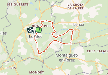
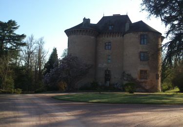
Randonnée Marche de 13,7 km à découvrir à Auvergne-Rhône-Alpes, Allier, Loddes. Cette randonnée est proposée par coco03.
Description
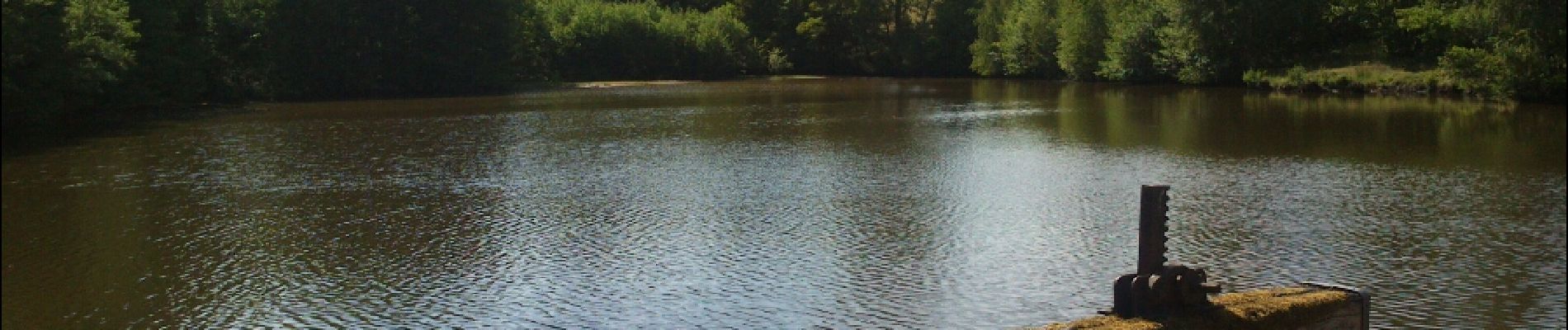
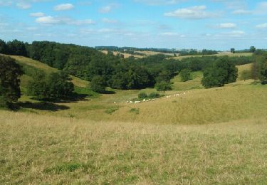
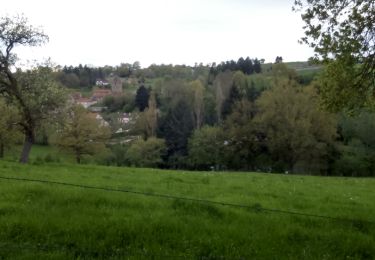
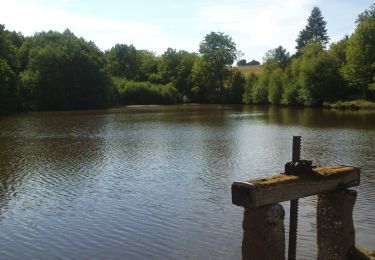
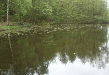
Circuit (route et chemins)agréable, assez ombragé avec de nombreux passages dans les bois. La pause à l'étang du moulin est très agréable.
Localisation
Pays :
France
Région :
Auvergne-Rhône-Alpes
Département/Province :
Allier
Commune :
Loddes
Localité :
Unknown
Départ:(Dec)
Départ:(UTM)
558939 ; 5126360 (31T) N.
Commentaires
Randonnées à proximité
![Randonnée Marche Bert - Boucle du Roc - BERT - Photo](https://media.geolcdn.com/t/375/260/ext.jpg?maxdim=2&url=https%3A%2F%2Fservices.sitytrail.com%2FGeolivesWS%2FDownloadMedia.ashx%3FTrailID%3D592542%26Media%3Dfix__20160703174517.jpg)
![Marche Marche](https://static1.geolcdn.com/sitytour/trail-icons/101.png)
Boucle du Roc - BERT
Marche
Moyen
(1)
Bert,
Auvergne-Rhône-Alpes,
Allier,
France
![](/images/other/stat-length.png)
12,5 km | 16,6 km-effort
3h 36min
![](https://static1.geolcdn.com/siteimages/upload/files/16400158638029165_repeat_loop_refresh_sync_direction_icon.png)
Oui
![Randonnée V.T.T. Montaiguët-en-Forez - Balade VTT en Val Libre - Montaiguët en Forez - Photo](https://media.geolcdn.com/t/375/260/ext.jpg?maxdim=2&url=https%3A%2F%2Fservices.sitytrail.com%2FGeolivesWS%2FDownloadMedia.ashx%3FTrailID%3D316978%26Media%3D16102_6.jpg)
![V.T.T. V.T.T.](https://static1.geolcdn.com/sitytour/trail-icons/202.png)
Balade VTT en Val Libre - Montaiguët en Forez
V.T.T.
Moyen
Montaiguët-en-Forez,
Auvergne-Rhône-Alpes,
Allier,
France
![](/images/other/stat-length.png)
32 km | 40 km-effort
2h 45min
![](https://static1.geolcdn.com/siteimages/upload/files/16400158638029165_repeat_loop_refresh_sync_direction_icon.png)
Oui
![Randonnée Marche Bert - Bert, la Tour Pouçain - Photo](https://media.geolcdn.com/t/375/260/ext.jpg?maxdim=2&url=https%3A%2F%2Fservices.sitytrail.com%2FGeolivesWS%2FDownloadMedia.ashx%3FTrailID%3D562087%26Media%3Dcada33ef-c0c2-4418-88c9-cf1559872ff7.JPG)
![Marche Marche](https://static1.geolcdn.com/sitytour/trail-icons/101.png)
Bert, la Tour Pouçain
Marche
Moyen
(1)
Bert,
Auvergne-Rhône-Alpes,
Allier,
France
![](/images/other/stat-length.png)
11,4 km | 14,7 km-effort
3h 19min
![](https://static1.geolcdn.com/siteimages/upload/files/16400158638029165_repeat_loop_refresh_sync_direction_icon.png)
Non
![Randonnée Marche Montaiguët-en-Forez -](https://media.geolcdn.com/t/375/260/ext.jpg?maxdim=2&url=https%3A%2F%2Fservices.sitytrail.com%2FGeolivesWS%2FDownloadMedia.ashx%3FTrailID%3D407615%26Media%3Dfix__20150412182217.jpg)
![Marche Marche](https://static1.geolcdn.com/sitytour/trail-icons/101.png)
"Circuit de l'étang du moulin" Montaiguët-en-Forez
Marche
Facile
Montaiguët-en-Forez,
Auvergne-Rhône-Alpes,
Allier,
France
![](/images/other/stat-length.png)
14 km | 17,2 km-effort
3h 43min
![](https://static1.geolcdn.com/siteimages/upload/files/16400158638029165_repeat_loop_refresh_sync_direction_icon.png)
Oui
![Randonnée Marche Loddes - Loddes ... Le Moulin - Photo](https://media.geolcdn.com/t/375/260/ext.jpg?maxdim=2&url=https%3A%2F%2Fservices.sitytrail.com%2FGeolivesWS%2FDownloadMedia.ashx%3FTrailID%3D309959%26Media%3Dfix__20140606170720.jpg)
![Marche Marche](https://static1.geolcdn.com/sitytour/trail-icons/101.png)
Loddes ... Le Moulin
Marche
Moyen
(1)
Loddes,
Auvergne-Rhône-Alpes,
Allier,
France
![](/images/other/stat-length.png)
8,9 km | 11,3 km-effort
2h 32min
![](https://static1.geolcdn.com/siteimages/upload/files/16400158638029165_repeat_loop_refresh_sync_direction_icon.png)
Oui
![Randonnée V.T.T. Montaiguët-en-Forez - autour de Montaguët en forez - Photo](https://media.geolcdn.com/t/375/260/ext.jpg?maxdim=2&url=https%3A%2F%2Fstatic1.geolcdn.com%2Fsiteimages%2Fupload%2Ffiles%2F1524743154velo.jpg)
![V.T.T. V.T.T.](https://static1.geolcdn.com/sitytour/trail-icons/202.png)
autour de Montaguët en forez
V.T.T.
Facile
Montaiguët-en-Forez,
Auvergne-Rhône-Alpes,
Allier,
France
![](/images/other/stat-length.png)
13,6 km | 16,8 km-effort
1h 9min
![](https://static1.geolcdn.com/siteimages/upload/files/16400158638029165_repeat_loop_refresh_sync_direction_icon.png)
Oui
![Randonnée Marche Andelaroche - Les Andais - Photo](https://media.geolcdn.com/t/375/260/ext.jpg?maxdim=2&url=https%3A%2F%2Fservices.sitytrail.com%2FGeolivesWS%2FDownloadMedia.ashx%3FTrailID%3D565858%26Media%3Dfix__20160508172713.jpg)
![Marche Marche](https://static1.geolcdn.com/sitytour/trail-icons/101.png)
Les Andais
Marche
Facile
Andelaroche,
Auvergne-Rhône-Alpes,
Allier,
France
![](/images/other/stat-length.png)
14,4 km | 18,3 km-effort
3h 31min
![](https://static1.geolcdn.com/siteimages/upload/files/16400158638029165_repeat_loop_refresh_sync_direction_icon.png)
Oui
![Randonnée Marche Andelaroche - Les Andais - Andelaroche - Photo](https://media.geolcdn.com/t/375/260/ext.jpg?maxdim=2&url=https%3A%2F%2Fstatic1.geolcdn.com%2Fsiteimages%2Fupload%2Ffiles%2F1553511878bg_sport_marche.png)
![Marche Marche](https://static1.geolcdn.com/sitytour/trail-icons/101.png)
Les Andais - Andelaroche
Marche
Moyen
Andelaroche,
Auvergne-Rhône-Alpes,
Allier,
France
![](/images/other/stat-length.png)
13,6 km | 17,5 km-effort
3h 0min
![](https://static1.geolcdn.com/siteimages/upload/files/16400158638029165_repeat_loop_refresh_sync_direction_icon.png)
Oui
![Randonnée Vélo Bert - Bert-Nuits st Georges - Photo](https://media.geolcdn.com/t/375/260/ext.jpg?maxdim=2&url=https%3A%2F%2Fstatic1.geolcdn.com%2Fsiteimages%2Fupload%2Ffiles%2F1524743154velo.jpg)
![Vélo Vélo](https://static1.geolcdn.com/sitytour/trail-icons/200.png)
Bert-Nuits st Georges
Vélo
Facile
Bert,
Auvergne-Rhône-Alpes,
Allier,
France
![](/images/other/stat-length.png)
163 km | 183 km-effort
Inconnu
![](https://static1.geolcdn.com/siteimages/upload/files/16400158638029165_repeat_loop_refresh_sync_direction_icon.png)
Non