Randonnée A pied Schwäbisch Hall - Rundwanderweg Schwäbisch Hall 1 - Photo

Tous les sentiers balisés d’Europe PRO

© OpenStreetMap contributors
Longueur
Longueur
14,2 km
Altitude max
Altitude max
513 m
Dénivelé positif
Dénivelé positif
344 m
Km-Effort
Km-Effort  
18,8 km
Altitude min
Altitude min
275 m
Dénivelé négatif
Dénivelé négatif
351 m
Boucle
Boucle
Oui
Balise
Balise
Date de création :
2022-02-11 18:20:36.473
Dernière modification :
2022-02-11 18:20:36.473

(0 Avis)

A pied
A pied
4h15
Difficulté : Facile

Scannez ce code QR pour ouvrir la randonnée dans l'application SityTrail

Application GPS de randonnée GRATUITE

Logo SityTrail SityTrail

IGN / Instituts géographiques

Télécharger SityTrail sur l'App Store Télécharger SityTrail sur Google Play

Logo SityTrail SityTrail World

Le monde est à vous

Télécharger SityTrail sur l'App Store Télécharger SityTrail sur Google Play Télécharger SityTrail sur Huawei AppGallery

À propos

Randonnée A pied de 14,2 km à découvrir à Bade-Wurtemberg, Landkreis Schwäbisch Hall, Schwäbisch Hall. Cette randonnée est proposée par SityTrail - itinéraires balisés pédestres.

Description

Weg ist nur in einer Richtung markiert

Symbole: Grüne 1 auf weißem Grund

Photos

Localisation

Pays :
Allemagne
Région :
Bade-Wurtemberg
Département/Province :
Landkreis Schwäbisch Hall
Commune :
Schwäbisch Hall
Localité :
Unknown
Départ:(UTM)
555136 ; 5438576 (32U) N.

Randonnées à proximité

Randonnée A pied Schwäbisch Hall - Waldspaziergang zum Lemberghaus - Photo
A pied
PRO

A pied

Facile
Schwäbisch Hall, Bade-Wurtemberg, Landkreis Schwäbisch Hall, Allemagne
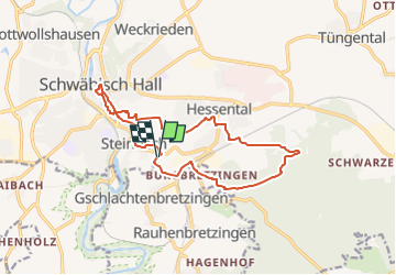
7,8 km | 10 km-effort
2h 16min
Oui


Fermer
Mes abonnements