![](/images/other/stat-length.png)
![Randonnée A pied Wilnsdorf - Rothaarsteig-Zuweg Rudersdorf - Photo](https://media.geolcdn.com/t/1900/400/ext.pjpeg?maxdim=2&url=https%3A%2F%2Fstatic1.geolcdn.com%2Fsiteimages%2Fupload%2Ffiles%2F1545311037marcheuse_200dpi.jpg)
Rothaarsteig-Zuweg Rudersdorf
SityTrail - itinéraires balisés pédestres
Tous les sentiers balisés d’Europe GUIDE+
![Longueur](/images/other/stat-length.png)
Longueur
4,3 km
![Altitude max](https://static1.geolcdn.com/siteimages/upload/files/1508320355ic_sort_altitude_max_24dp.png)
Altitude max
556 m
![Dénivelé positif](https://static1.geolcdn.com/siteimages/upload/files/1508320355ic_sort_den_pos_24dp.png)
Dénivelé positif
33 m
![Km-Effort](/images/other/stat-length.png)
Km-Effort
5,3 km
![Altitude min](https://static1.geolcdn.com/siteimages/upload/files/1508320355ic_sort_altitude_min_24dp.png)
Altitude min
346 m
![Dénivelé négatif](https://static1.geolcdn.com/siteimages/upload/files/1508320355ic_sort_den_neg_24dp.png)
Dénivelé négatif
226 m
![Boucle](https://static1.geolcdn.com/siteimages/upload/files/16400158638029165_repeat_loop_refresh_sync_direction_icon.png)
Boucle
Non
Balise
Date de création :
2022-02-11 18:16:23.293
Dernière modification :
2022-02-11 18:16:23.293
![A pied](https://static1.geolcdn.com/sitytour/trail-icons/100.png)
1h12
Difficulté : Facile
![Scannez ce code QR pour ouvrir la randonnée dans l'application SityTrail](https://capi.geolives.com/qq0zvz2zws4bq2lad0pu/sitytour/trails/3099230/qr.png?size=200)
Application GPS de randonnée GRATUITE
À propos
Randonnée A pied de 4,3 km à découvrir à Rhénanie-du-Nord-Westphalie, Kreis Siegen-Wittgenstein, Wilnsdorf. Cette randonnée est proposée par SityTrail - itinéraires balisés pédestres.
Description
Randonnée créée par Rothaarsteigverein.
Localisation
Pays :
Allemagne
Région :
Rhénanie-du-Nord-Westphalie
Département/Province :
Kreis Siegen-Wittgenstein
Commune :
Wilnsdorf
Localité :
Unknown
Départ:(Dec)
Départ:(UTM)
441761 ; 5629828 (32U) N.
Commentaires
Randonnées à proximité
![Randonnée A pied Haiger - Rothaarsteig-Spur Dill-Bergtour - Photo](https://media.geolcdn.com/t/375/260/7aedcd41-5b62-4247-a70d-40d58104e322.jpeg&format=jpg&maxdim=2)
![A pied A pied](https://static1.geolcdn.com/sitytour/trail-icons/100.png)
Rothaarsteig-Spur Dill-Bergtour
A pied
Moyen
Haiger,
Hesse,
Lahn-Dill-Kreis,
Allemagne
![](/images/other/stat-length.png)
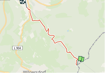
15,9 km | 22 km-effort
4h 53min
![](https://static1.geolcdn.com/siteimages/upload/files/16400158638029165_repeat_loop_refresh_sync_direction_icon.png)
Oui
![Randonnée A pied Wilnsdorf - Auf Bergmannspfaden - Photo](https://media.geolcdn.com/t/375/260/371a93d2-a99f-4c23-af34-75110e2dd7d9.jpeg&format=jpg&maxdim=2)
![A pied A pied](https://static1.geolcdn.com/sitytour/trail-icons/100.png)
Auf Bergmannspfaden
A pied
Facile
Wilnsdorf,
Rhénanie-du-Nord-Westphalie,
Kreis Siegen-Wittgenstein,
Allemagne
![](/images/other/stat-length.png)
14,7 km | 19,6 km-effort
4h 26min
![](https://static1.geolcdn.com/siteimages/upload/files/16400158638029165_repeat_loop_refresh_sync_direction_icon.png)
Oui
![Randonnée A pied Netphen - (I) Sonnenweg - Photo](https://media.geolcdn.com/t/375/260/036722c9-52b3-4e38-a7e0-927b99207e8f.jpeg&format=jpg&maxdim=2)
![A pied A pied](https://static1.geolcdn.com/sitytour/trail-icons/100.png)
(I) Sonnenweg
A pied
Facile
Netphen,
Rhénanie-du-Nord-Westphalie,
Kreis Siegen-Wittgenstein,
Allemagne
![](/images/other/stat-length.png)
13,4 km | 17,8 km-effort
4h 3min
![](https://static1.geolcdn.com/siteimages/upload/files/16400158638029165_repeat_loop_refresh_sync_direction_icon.png)
Oui
![Randonnée A pied Haiger - Rothaarsteig-Zuweg Dillbrecht - Photo](https://media.geolcdn.com/t/375/260/ext.jpg?maxdim=2&url=https%3A%2F%2Fstatic1.geolcdn.com%2Fsiteimages%2Fupload%2Ffiles%2F1545311037marcheuse_200dpi.jpg)
![A pied A pied](https://static1.geolcdn.com/sitytour/trail-icons/100.png)
Rothaarsteig-Zuweg Dillbrecht
A pied
Facile
Haiger,
Hesse,
Lahn-Dill-Kreis,
Allemagne
![](/images/other/stat-length.png)
3,3 km | 4,2 km-effort
57min
![](https://static1.geolcdn.com/siteimages/upload/files/16400158638029165_repeat_loop_refresh_sync_direction_icon.png)
Non
![Randonnée A pied Netphen - Hainchen Rundweg A4 - Photo](https://media.geolcdn.com/t/375/260/7aedcd41-5b62-4247-a70d-40d58104e322.jpeg&format=jpg&maxdim=2)
![A pied A pied](https://static1.geolcdn.com/sitytour/trail-icons/100.png)
Hainchen Rundweg A4
A pied
Facile
Netphen,
Rhénanie-du-Nord-Westphalie,
Kreis Siegen-Wittgenstein,
Allemagne
![](/images/other/stat-length.png)
4 km | 5,5 km-effort
1h 15min
![](https://static1.geolcdn.com/siteimages/upload/files/16400158638029165_repeat_loop_refresh_sync_direction_icon.png)
Non
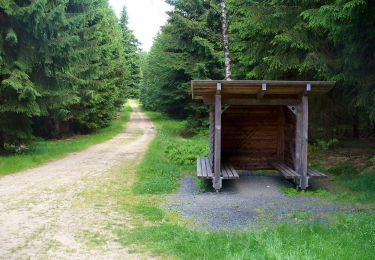
![Randonnée A pied Netphen - [T] Wilgersdorf - Obernau-Talsperre - Photo](https://media.geolcdn.com/t/375/260/389e4f43-5878-4a39-9b36-4bfe793beb15.jpeg&format=jpg&maxdim=2)
![A pied A pied](https://static1.geolcdn.com/sitytour/trail-icons/100.png)
[T] Wilgersdorf - Obernau-Talsperre
A pied
Facile
Netphen,
Rhénanie-du-Nord-Westphalie,
Kreis Siegen-Wittgenstein,
Allemagne
![](/images/other/stat-length.png)
4,3 km | 6,1 km-effort
1h 22min
![](https://static1.geolcdn.com/siteimages/upload/files/16400158638029165_repeat_loop_refresh_sync_direction_icon.png)
Non
![Randonnée A pied Wilnsdorf - Rudersdorf Rundweg A7 - Photo](https://media.geolcdn.com/t/375/260/ext.jpg?maxdim=2&url=https%3A%2F%2Fstatic1.geolcdn.com%2Fsiteimages%2Fupload%2Ffiles%2F1545311037marcheuse_200dpi.jpg)
![A pied A pied](https://static1.geolcdn.com/sitytour/trail-icons/100.png)
Rudersdorf Rundweg A7
A pied
Facile
Wilnsdorf,
Rhénanie-du-Nord-Westphalie,
Kreis Siegen-Wittgenstein,
Allemagne
![](/images/other/stat-length.png)
3,2 km | 3,7 km-effort
50min
![](https://static1.geolcdn.com/siteimages/upload/files/16400158638029165_repeat_loop_refresh_sync_direction_icon.png)
Non
![Randonnée A pied Wilnsdorf - Winkel Rudersdorf-Offdilln - Photo](https://media.geolcdn.com/t/375/260/ext.jpg?maxdim=2&url=https%3A%2F%2Fstatic1.geolcdn.com%2Fsiteimages%2Fupload%2Ffiles%2F1545311037marcheuse_200dpi.jpg)
![A pied A pied](https://static1.geolcdn.com/sitytour/trail-icons/100.png)
Winkel Rudersdorf-Offdilln
A pied
Facile
Wilnsdorf,
Rhénanie-du-Nord-Westphalie,
Kreis Siegen-Wittgenstein,
Allemagne
![](/images/other/stat-length.png)
5 km | 7,4 km-effort
1h 40min
![](https://static1.geolcdn.com/siteimages/upload/files/16400158638029165_repeat_loop_refresh_sync_direction_icon.png)
Non