![](/images/other/stat-length.png)
![Randonnée A pied Bad Camberg - Rundwanderweg Oberselters 2 - Photo](https://media.geolcdn.com/t/1900/400/ext.pjpeg?maxdim=2&url=https%3A%2F%2Fmedia.geolcdn.com%2Ff%2F93fc9f0c-4f78-4b86-ae2c-ee6e5fd91f0e.jpeg)
Rundwanderweg Oberselters 2
SityTrail - itinéraires balisés pédestres
Tous les sentiers balisés d’Europe PRO
![Longueur](/images/other/stat-length.png)
Longueur
3,1 km
![Altitude max](https://static1.geolcdn.com/siteimages/upload/files/1508320355ic_sort_altitude_max_24dp.png)
Altitude max
332 m
![Dénivelé positif](https://static1.geolcdn.com/siteimages/upload/files/1508320355ic_sort_den_pos_24dp.png)
Dénivelé positif
163 m
![Km-Effort](/images/other/stat-length.png)
Km-Effort
4,7 km
![Altitude min](https://static1.geolcdn.com/siteimages/upload/files/1508320355ic_sort_altitude_min_24dp.png)
Altitude min
169 m
![Dénivelé négatif](https://static1.geolcdn.com/siteimages/upload/files/1508320355ic_sort_den_neg_24dp.png)
Dénivelé négatif
4 m
![Boucle](https://static1.geolcdn.com/siteimages/upload/files/16400158638029165_repeat_loop_refresh_sync_direction_icon.png)
Boucle
Non
Balise
Date de création :
2022-02-11 18:11:00.519
Dernière modification :
2022-02-11 18:11:00.519
![A pied](https://static1.geolcdn.com/sitytour/trail-icons/100.png)
1h04
Difficulté : Facile
![Scannez ce code QR pour ouvrir la randonnée dans l'application SityTrail](https://capi.geolives.com/qq0zvz2zws4bq2lad0pu/sitytour/trails/3099121/qr.png?size=200)
Application GPS de randonnée GRATUITE
À propos
Randonnée A pied de 3,1 km à découvrir à Hesse, Landkreis Limburg-Weilburg, Bad Camberg. Cette randonnée est proposée par SityTrail - itinéraires balisés pédestres.
Description
Symbole: weißes Schild mit dünnem, orangen, rechteckigen Rahmen mit abgerundeten Ecken, darin fett und auch in orange "O2"
Localisation
Pays :
Allemagne
Région :
Hesse
Département/Province :
Landkreis Limburg-Weilburg
Commune :
Bad Camberg
Localité :
Unknown
Départ:(Dec)
Départ:(UTM)
445994 ; 5575768 (32U) N.
Commentaires
Randonnées à proximité
![Randonnée A pied Brechen - Rundweg Niederbrechen-Oberbrechen-Niederbrechen - Photo](https://media.geolcdn.com/t/375/260/ext.jpg?maxdim=2&url=https%3A%2F%2Fstatic1.geolcdn.com%2Fsiteimages%2Fupload%2Ffiles%2F1545311037marcheuse_200dpi.jpg)
![A pied A pied](https://static1.geolcdn.com/sitytour/trail-icons/100.png)
Rundweg Niederbrechen-Oberbrechen-Niederbrechen
A pied
Facile
Brechen,
Hesse,
Landkreis Limburg-Weilburg,
Allemagne
![](/images/other/stat-length.png)
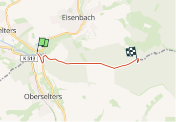
3,9 km | 4,8 km-effort
1h 5min
![](https://static1.geolcdn.com/siteimages/upload/files/16400158638029165_repeat_loop_refresh_sync_direction_icon.png)
Non