![](/images/other/stat-length.png)
![Randonnée A pied Gersfeld - Rhön-Rundweg 1 Horstberg - Photo](https://media.geolcdn.com/t/1900/400/ext.pjpeg?maxdim=2&url=https%3A%2F%2Fmedia.geolcdn.com%2Ff%2Fc47a0b08-6dcc-41a2-b412-9d3d18edb3b4.jpeg)
Rhön-Rundweg 1 Horstberg
SityTrail - itinéraires balisés pédestres
Tous les sentiers balisés d’Europe PRO
![Longueur](/images/other/stat-length.png)
Longueur
3,2 km
![Altitude max](https://static1.geolcdn.com/siteimages/upload/files/1508320355ic_sort_altitude_max_24dp.png)
Altitude max
513 m
![Dénivelé positif](https://static1.geolcdn.com/siteimages/upload/files/1508320355ic_sort_den_pos_24dp.png)
Dénivelé positif
73 m
![Km-Effort](/images/other/stat-length.png)
Km-Effort
4,2 km
![Altitude min](https://static1.geolcdn.com/siteimages/upload/files/1508320355ic_sort_altitude_min_24dp.png)
Altitude min
446 m
![Dénivelé négatif](https://static1.geolcdn.com/siteimages/upload/files/1508320355ic_sort_den_neg_24dp.png)
Dénivelé négatif
72 m
![Boucle](https://static1.geolcdn.com/siteimages/upload/files/16400158638029165_repeat_loop_refresh_sync_direction_icon.png)
Boucle
Oui
Balise
Date de création :
2022-02-11 17:57:53.889
Dernière modification :
2022-02-11 17:57:53.889
![A pied](https://static1.geolcdn.com/sitytour/trail-icons/100.png)
57m
Difficulté : Facile
![Scannez ce code QR pour ouvrir la randonnée dans l'application SityTrail](https://capi.geolives.com/qq0zvz2zws4bq2lad0pu/sitytour/trails/3098834/qr.png?size=200)
Application GPS de randonnée GRATUITE
À propos
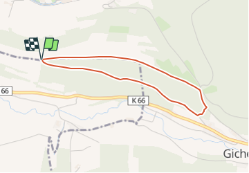
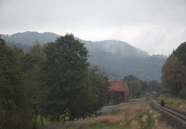
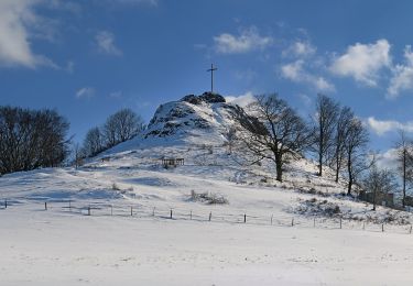
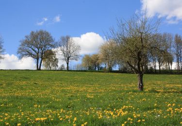
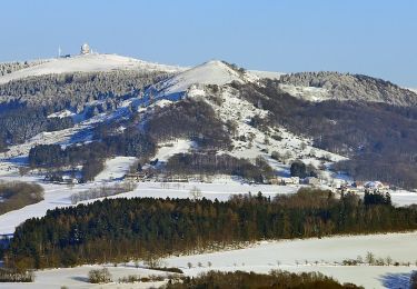
Randonnée A pied de 3,2 km à découvrir à Hesse, Landkreis Fulda, Gersfeld. Cette randonnée est proposée par SityTrail - itinéraires balisés pédestres.
Description
Randonnée créée par Naturpark Hessische Rhön.
incomplete
Symbole: white 1 on blue
Localisation
Pays :
Allemagne
Région :
Hesse
Département/Province :
Landkreis Fulda
Commune :
Gersfeld
Localité :
Unknown
Départ:(Dec)
Départ:(UTM)
557628 ; 5588295 (32U) N.
Commentaires
Randonnées à proximité
![Randonnée A pied Ebersburg - Rhön-Rundweg 1 Wachholderhuette - Photo](https://media.geolcdn.com/t/375/260/ext.jpg?maxdim=2&url=https%3A%2F%2Fmedia.geolcdn.com%2Ff%2F53c7ee77-d2b4-43ef-ac1d-b74b83bcf33e.jpeg)
![A pied A pied](https://static1.geolcdn.com/sitytour/trail-icons/100.png)
Rhön-Rundweg 1 Wachholderhuette
A pied
Facile
Ebersburg,
Hesse,
Landkreis Fulda,
Allemagne
![](/images/other/stat-length.png)
5,7 km | 8,1 km-effort
1h 50min
![](https://static1.geolcdn.com/siteimages/upload/files/16400158638029165_repeat_loop_refresh_sync_direction_icon.png)
Oui
![Randonnée A pied Gersfeld - Rhön-Rundweg 3 Dalherda - Photo](https://media.geolcdn.com/t/375/260/ext.jpg?maxdim=2&url=https%3A%2F%2Fmedia.geolcdn.com%2Ff%2F508915a8-6988-4c95-b465-c3ee89a15ee6.jpeg)
![A pied A pied](https://static1.geolcdn.com/sitytour/trail-icons/100.png)
Rhön-Rundweg 3 Dalherda
A pied
Facile
Gersfeld,
Hesse,
Landkreis Fulda,
Allemagne
![](/images/other/stat-length.png)
4,2 km | 6 km-effort
1h 21min
![](https://static1.geolcdn.com/siteimages/upload/files/16400158638029165_repeat_loop_refresh_sync_direction_icon.png)
Oui
![Randonnée A pied Gersfeld - Rhön-Rundweg 2 Dalherda - Photo](https://media.geolcdn.com/t/375/260/ext.jpg?maxdim=2&url=https%3A%2F%2Fmedia.geolcdn.com%2Ff%2F508915a8-6988-4c95-b465-c3ee89a15ee6.jpeg)
![A pied A pied](https://static1.geolcdn.com/sitytour/trail-icons/100.png)
Rhön-Rundweg 2 Dalherda
A pied
Facile
Gersfeld,
Hesse,
Landkreis Fulda,
Allemagne
![](/images/other/stat-length.png)
8,7 km | 11,8 km-effort
2h 40min
![](https://static1.geolcdn.com/siteimages/upload/files/16400158638029165_repeat_loop_refresh_sync_direction_icon.png)
Non
![Randonnée A pied Gersfeld - Rhön-Rundweg 2 Horstberg - Photo](https://media.geolcdn.com/t/375/260/ext.jpg?maxdim=2&url=https%3A%2F%2Fmedia.geolcdn.com%2Ff%2F180e4496-d0e2-409e-98f9-c36e2540c0a3.jpeg)
![A pied A pied](https://static1.geolcdn.com/sitytour/trail-icons/100.png)
Rhön-Rundweg 2 Horstberg
A pied
Facile
Gersfeld,
Hesse,
Landkreis Fulda,
Allemagne
![](/images/other/stat-length.png)
4,8 km | 6,6 km-effort
1h 29min
![](https://static1.geolcdn.com/siteimages/upload/files/16400158638029165_repeat_loop_refresh_sync_direction_icon.png)
Oui
![Randonnée A pied Poppenhausen - Poppenhausen - Wachtkueppel - Photo](https://media.geolcdn.com/t/375/260/ext.jpg?maxdim=2&url=https%3A%2F%2Fmedia.geolcdn.com%2Ff%2F7f47fa62-95a9-4e0f-b414-afaeb3aa169f.jpeg)
![A pied A pied](https://static1.geolcdn.com/sitytour/trail-icons/100.png)
Poppenhausen - Wachtkueppel
A pied
Facile
Poppenhausen,
Hesse,
Landkreis Fulda,
Allemagne
![](/images/other/stat-length.png)
3,3 km | 5,4 km-effort
1h 14min
![](https://static1.geolcdn.com/siteimages/upload/files/16400158638029165_repeat_loop_refresh_sync_direction_icon.png)
Non
![Randonnée A pied Gersfeld - Rhön-Rundweg 11 Wachtkueppel - Photo](https://media.geolcdn.com/t/375/260/ext.jpg?maxdim=2&url=https%3A%2F%2Fmedia.geolcdn.com%2Ff%2F4d0391f6-7c4e-42ec-95d7-af5fb8138470.jpeg)
![A pied A pied](https://static1.geolcdn.com/sitytour/trail-icons/100.png)
Rhön-Rundweg 11 Wachtkueppel
A pied
Facile
Gersfeld,
Hesse,
Landkreis Fulda,
Allemagne
![](/images/other/stat-length.png)
3,8 km | 5,1 km-effort
1h 9min
![](https://static1.geolcdn.com/siteimages/upload/files/16400158638029165_repeat_loop_refresh_sync_direction_icon.png)
Oui
![Randonnée A pied Ebersburg - Rhön-Rundweg 2 Weyhers - Photo](https://media.geolcdn.com/t/375/260/ext.jpg?maxdim=2&url=https%3A%2F%2Fmedia.geolcdn.com%2Ff%2F3ca47a21-a7e6-469c-b297-40ad66d9a0d3.jpeg)
![A pied A pied](https://static1.geolcdn.com/sitytour/trail-icons/100.png)
Rhön-Rundweg 2 Weyhers
A pied
Facile
Ebersburg,
Hesse,
Landkreis Fulda,
Allemagne
![](/images/other/stat-length.png)
4,8 km | 6,4 km-effort
1h 26min
![](https://static1.geolcdn.com/siteimages/upload/files/16400158638029165_repeat_loop_refresh_sync_direction_icon.png)
Oui
![Randonnée A pied Ebersburg - Rhön-Rundweg 1 Ebersburg - Photo](https://media.geolcdn.com/t/375/260/ext.jpg?maxdim=2&url=https%3A%2F%2Fmedia.geolcdn.com%2Ff%2F021406c3-1785-41ee-9e5e-d3ab8ecd0872.jpeg)
![A pied A pied](https://static1.geolcdn.com/sitytour/trail-icons/100.png)
Rhön-Rundweg 1 Ebersburg
A pied
Facile
Ebersburg,
Hesse,
Landkreis Fulda,
Allemagne
![](/images/other/stat-length.png)
4,5 km | 7,1 km-effort
1h 36min
![](https://static1.geolcdn.com/siteimages/upload/files/16400158638029165_repeat_loop_refresh_sync_direction_icon.png)
Oui
![Randonnée A pied Poppenhausen - Poppenhausen - Altenfeld - Photo](https://media.geolcdn.com/t/375/260/ext.jpg?maxdim=2&url=https%3A%2F%2Fmedia.geolcdn.com%2Ff%2F7f47fa62-95a9-4e0f-b414-afaeb3aa169f.jpeg)
![A pied A pied](https://static1.geolcdn.com/sitytour/trail-icons/100.png)
Poppenhausen - Altenfeld
A pied
Facile
Poppenhausen,
Hesse,
Landkreis Fulda,
Allemagne
![](/images/other/stat-length.png)
6,1 km | 8,5 km-effort
1h 56min
![](https://static1.geolcdn.com/siteimages/upload/files/16400158638029165_repeat_loop_refresh_sync_direction_icon.png)
Non