


3,7 km | 4,4 km-effort
![Randonnée A pied Detmold - Rundwanderweg A3 [Berlebeck / Hangstein] - Photo](https://media.geolcdn.com/t/1900/400/09e96dc8-2a72-420e-af43-8a0b6d458613.jpeg&format=pjpeg&maxdim=2)

Tous les sentiers balisés d’Europe GUIDE+


Application GPS de randonnée GRATUITE
 SityTrail
IGN / Instituts géographiques
SityTrail World
Le monde est à vous
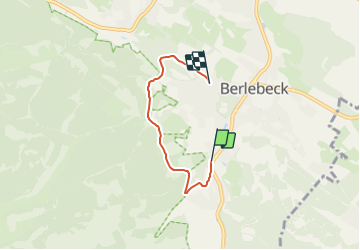
Randonnée A pied de 3,3 km à découvrir à Rhénanie-du-Nord-Westphalie, Kreis Lippe, Detmold. Cette randonnée est proposée par SityTrail - itinéraires balisés pédestres.
Randonnée créée par Lippischer Heimatverein.
![Randonnée A pied Detmold - Rundwanderweg A3 [Berlebeck / Hangstein] - Photo 1](https://media.geolcdn.com/t/2048/auto/e7ac3911-93fc-4795-8b03-49e6f8d78e2f.jpeg&format=jpg&maxdim=0 "Randonnée A pied Detmold - Rundwanderweg A3 [Berlebeck / Hangstein] - Photo 1")
![Randonnée A pied Detmold - Rundwanderweg A3 [Berlebeck / Hangstein] - Photo 2](https://media.geolcdn.com/t/2048/auto/12a23c97-8482-4a3d-a489-7f2e461e0d60.jpeg&format=jpg&maxdim=0 "Randonnée A pied Detmold - Rundwanderweg A3 [Berlebeck / Hangstein] - Photo 2")
![Randonnée A pied Detmold - Rundwanderweg A3 [Berlebeck / Hangstein] - Photo 3](https://media.geolcdn.com/t/2048/auto/bd7f2ec6-2429-4ee7-9028-3b6160db5d1f.jpeg&format=jpg&maxdim=0 "Randonnée A pied Detmold - Rundwanderweg A3 [Berlebeck / Hangstein] - Photo 3")
![Randonnée A pied Detmold - Rundwanderweg A3 [Berlebeck / Hangstein] - Photo 4](https://media.geolcdn.com/t/2048/auto/dc09c2c8-da64-4d5f-b357-677a2d46a09e.jpeg&format=jpg&maxdim=0 "Randonnée A pied Detmold - Rundwanderweg A3 [Berlebeck / Hangstein] - Photo 4")
![Randonnée A pied Detmold - Rundwanderweg A3 [Berlebeck / Hangstein] - Photo 5](https://media.geolcdn.com/t/2048/auto/3c91ec98-bf47-4e4a-8194-a19c819bbb39.jpeg&format=jpg&maxdim=0 "Randonnée A pied Detmold - Rundwanderweg A3 [Berlebeck / Hangstein] - Photo 5")
![Randonnée A pied Detmold - Rundwanderweg A3 [Berlebeck / Hangstein] - Photo 6](https://media.geolcdn.com/t/2048/auto/006a1ebf-c18b-490d-895b-5536975bf3dc.jpeg&format=jpg&maxdim=0 "Randonnée A pied Detmold - Rundwanderweg A3 [Berlebeck / Hangstein] - Photo 6")
![Randonnée A pied Detmold - Rundwanderweg A3 [Berlebeck / Hangstein] - Photo 7](https://media.geolcdn.com/t/2048/auto/a10ffad1-a998-4ee3-ae03-506206f2cb15.jpeg&format=jpg&maxdim=0 "Randonnée A pied Detmold - Rundwanderweg A3 [Berlebeck / Hangstein] - Photo 7")
![Randonnée A pied Detmold - Rundwanderweg A3 [Berlebeck / Hangstein] - Photo 8](https://media.geolcdn.com/t/2048/auto/bb19cf9c-8e2e-435b-a06b-eac7e39b6713.jpeg&format=jpg&maxdim=0 "Randonnée A pied Detmold - Rundwanderweg A3 [Berlebeck / Hangstein] - Photo 8")
![Randonnée A pied Detmold - Rundwanderweg A3 [Berlebeck / Hangstein] - Photo 9](https://media.geolcdn.com/t/2048/auto/09e96dc8-2a72-420e-af43-8a0b6d458613.jpeg&format=jpg&maxdim=0 "Randonnée A pied Detmold - Rundwanderweg A3 [Berlebeck / Hangstein] - Photo 9")
![Randonnée A pied Detmold - Rundwanderweg A3 [Berlebeck / Hangstein] - Photo 10](https://media.geolcdn.com/t/2048/auto/71cab782-88c9-4172-a0bb-5010de69666e.jpeg&format=jpg&maxdim=0 "Randonnée A pied Detmold - Rundwanderweg A3 [Berlebeck / Hangstein] - Photo 10")
A pied
![Randonnée A pied Detmold - Rundwanderweg A5 [Berlebeck] - Photo](https://media.geolcdn.com/t/375/260/09e96dc8-2a72-420e-af43-8a0b6d458613.jpeg&format=jpg&maxdim=2)
A pied
A pied
![Randonnée A pied Horn-Bad Meinberg - Rundwanderweg A1 [Holzhausen-Externsteine] - Photo](https://media.geolcdn.com/t/375/260/917c6440-8043-45d4-9c08-101f3367a522.jpeg&format=jpg&maxdim=2)
A pied
![Randonnée A pied Detmold - Rundwanderweg [Gauseköte] - Photo](https://media.geolcdn.com/t/375/260/b23ec4a7-b5cb-44c3-a014-f0b25ad95715.jpeg&format=jpg&maxdim=2)
A pied
![Randonnée A pied Schlangen - Rundwanderweg 34 [Barnacken] - Photo](https://media.geolcdn.com/t/375/260/83e8c965-88dc-4fa7-9331-4da86113c518.jpeg&format=jpg&maxdim=2)
A pied
![Randonnée A pied Horn-Bad Meinberg - Rundwanderweg A5 [Horn] - Photo](https://media.geolcdn.com/t/375/260/4fb4c3bc-36b1-4cb9-b69c-377d560ed1e3.jpeg&format=jpg&maxdim=2)
A pied
![Randonnée A pied Horn-Bad Meinberg - Rundwanderweg A2 [Holzhausen-Externsteine] - Photo](https://media.geolcdn.com/t/375/260/496f2643-585c-4ec3-ad5f-48d37358ba78.jpeg&format=jpg&maxdim=2)
A pied
![Randonnée A pied Detmold - Alter Postweg [Schlangen-Kreuzkrug bis Detmold] - Photo](https://media.geolcdn.com/t/375/260/9624b63f-e63d-4566-afac-fe6174b35d1f.jpeg&format=jpg&maxdim=2)
A pied