![](/images/other/stat-length.png)
![Randonnée A pied Ober-Ramstadt - Rundwanderweg Geisenwald - Photo](https://media.geolcdn.com/t/1900/400/20159f53-0e50-4216-b2e8-a19cc37a638a.jpeg&format=pjpeg&maxdim=2)
Rundwanderweg Geisenwald
SityTrail - itinéraires balisés pédestres
Tous les sentiers balisés d’Europe GUIDE+
![Longueur](/images/other/stat-length.png)
Longueur
4,7 km
![Altitude max](https://static1.geolcdn.com/siteimages/upload/files/1508320355ic_sort_altitude_max_24dp.png)
Altitude max
269 m
![Dénivelé positif](https://static1.geolcdn.com/siteimages/upload/files/1508320355ic_sort_den_pos_24dp.png)
Dénivelé positif
134 m
![Km-Effort](/images/other/stat-length.png)
Km-Effort
6,5 km
![Altitude min](https://static1.geolcdn.com/siteimages/upload/files/1508320355ic_sort_altitude_min_24dp.png)
Altitude min
190 m
![Dénivelé négatif](https://static1.geolcdn.com/siteimages/upload/files/1508320355ic_sort_den_neg_24dp.png)
Dénivelé négatif
126 m
![Boucle](https://static1.geolcdn.com/siteimages/upload/files/16400158638029165_repeat_loop_refresh_sync_direction_icon.png)
Boucle
Oui
Balise
Date de création :
2022-02-11 17:52:42.894
Dernière modification :
2022-02-11 17:52:42.894
![A pied](https://static1.geolcdn.com/sitytour/trail-icons/100.png)
1h28
Difficulté : Facile
![Scannez ce code QR pour ouvrir la randonnée dans l'application SityTrail](https://capi.geolives.com/qq0zvz2zws4bq2lad0pu/sitytour/trails/3098687/qr.png?size=200)
Application GPS de randonnée GRATUITE
À propos
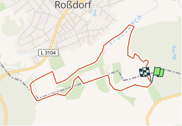
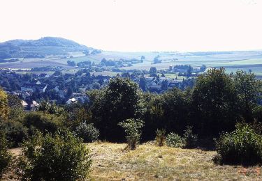
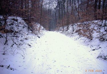
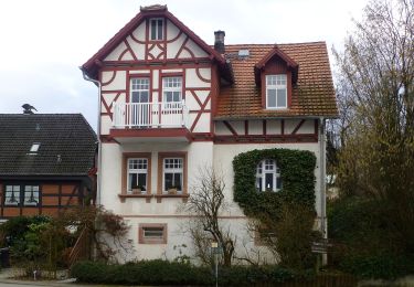
Randonnée A pied de 4,7 km à découvrir à Hesse, Landkreis Darmstadt-Dieburg, Ober-Ramstadt. Cette randonnée est proposée par SityTrail - itinéraires balisés pédestres.
Description
Symbole: gray hexagon on a green background
Localisation
Pays :
Allemagne
Région :
Hesse
Département/Province :
Landkreis Darmstadt-Dieburg
Commune :
Ober-Ramstadt
Localité :
Unknown
Départ:(Dec)
Départ:(UTM)
483466 ; 5521821 (32U) N.
Commentaires
Randonnées à proximité
![Randonnée A pied Ober-Ramstadt - Rundwanderweg Ober-Ramstadt Am Kuhfalltor 4: Buchwald-Weg - Photo](https://media.geolcdn.com/t/375/260/704ded18-e5b0-4708-815d-7055e4b4e14c.jpeg&format=jpg&maxdim=2)
![A pied A pied](https://static1.geolcdn.com/sitytour/trail-icons/100.png)
Rundwanderweg Ober-Ramstadt Am Kuhfalltor 4: Buchwald-Weg
A pied
Facile
Ober-Ramstadt,
Hesse,
Landkreis Darmstadt-Dieburg,
Allemagne
![](/images/other/stat-length.png)
4,5 km | 5,8 km-effort
1h 19min
![](https://static1.geolcdn.com/siteimages/upload/files/16400158638029165_repeat_loop_refresh_sync_direction_icon.png)
Oui
![Randonnée A pied Inconnu - Rundwanderweg Darmstadt 3 - Photo](https://media.geolcdn.com/t/375/260/dd3e7ec2-9c4e-43ca-9b63-5cc0f90e5365.jpeg&format=jpg&maxdim=2)
![A pied A pied](https://static1.geolcdn.com/sitytour/trail-icons/100.png)
Rundwanderweg Darmstadt 3
A pied
Facile
Inconnu,
Hesse,
Darmstadt,
Allemagne
![](/images/other/stat-length.png)
6,6 km | 7,9 km-effort
1h 47min
![](https://static1.geolcdn.com/siteimages/upload/files/16400158638029165_repeat_loop_refresh_sync_direction_icon.png)
Oui
![Randonnée A pied Ober-Ramstadt - Rundwanderweg Ober-Ramstadt Am Kuhfalltor 3: Geisenwald-Weg - Photo](https://media.geolcdn.com/t/375/260/3abb395d-91ca-4b1b-98ab-df94d0efc117.jpeg&format=jpg&maxdim=2)
![A pied A pied](https://static1.geolcdn.com/sitytour/trail-icons/100.png)
Rundwanderweg Ober-Ramstadt Am Kuhfalltor 3: Geisenwald-Weg
A pied
Facile
Ober-Ramstadt,
Hesse,
Landkreis Darmstadt-Dieburg,
Allemagne
![](/images/other/stat-length.png)
4,2 km | 5,5 km-effort
1h 14min
![](https://static1.geolcdn.com/siteimages/upload/files/16400158638029165_repeat_loop_refresh_sync_direction_icon.png)
Oui
![Randonnée A pied Ober-Ramstadt - Ortsrundwanderweg Roßdorf 1 - Photo](https://media.geolcdn.com/t/375/260/3abb395d-91ca-4b1b-98ab-df94d0efc117.jpeg&format=jpg&maxdim=2)
![A pied A pied](https://static1.geolcdn.com/sitytour/trail-icons/100.png)
Ortsrundwanderweg Roßdorf 1
A pied
Facile
Ober-Ramstadt,
Hesse,
Landkreis Darmstadt-Dieburg,
Allemagne
![](/images/other/stat-length.png)
6,5 km | 7,9 km-effort
1h 47min
![](https://static1.geolcdn.com/siteimages/upload/files/16400158638029165_repeat_loop_refresh_sync_direction_icon.png)
Oui
![Randonnée A pied Ober-Ramstadt - Ortsrundwanderweg Ober-Ramstadt 1 - Photo](https://media.geolcdn.com/t/375/260/cc8096db-584b-4fac-abc7-1ab2f3157b0f.jpeg&format=jpg&maxdim=2)
![A pied A pied](https://static1.geolcdn.com/sitytour/trail-icons/100.png)
Ortsrundwanderweg Ober-Ramstadt 1
A pied
Facile
Ober-Ramstadt,
Hesse,
Landkreis Darmstadt-Dieburg,
Allemagne
![](/images/other/stat-length.png)
4,2 km | 5,2 km-effort
1h 10min
![](https://static1.geolcdn.com/siteimages/upload/files/16400158638029165_repeat_loop_refresh_sync_direction_icon.png)
Non
![Randonnée A pied Roßdorf - Rundwanderweg Dieburg Kubigbrücke 2: Hasenböhlweg - Photo](https://media.geolcdn.com/t/375/260/7a377d21-1014-4b53-bcbd-5b2fd4f3fc25.jpeg&format=jpg&maxdim=2)
![A pied A pied](https://static1.geolcdn.com/sitytour/trail-icons/100.png)
Rundwanderweg Dieburg Kubigbrücke 2: Hasenböhlweg
A pied
Facile
Roßdorf,
Hesse,
Landkreis Darmstadt-Dieburg,
Allemagne
![](/images/other/stat-length.png)
5,7 km | 6,8 km-effort
1h 32min
![](https://static1.geolcdn.com/siteimages/upload/files/16400158638029165_repeat_loop_refresh_sync_direction_icon.png)
Oui
![Randonnée A pied Roßdorf - Rundwanderweg Dieburg Kubigbrücke 1: Brunners-Weg - Photo](https://media.geolcdn.com/t/375/260/7a377d21-1014-4b53-bcbd-5b2fd4f3fc25.jpeg&format=jpg&maxdim=2)
![A pied A pied](https://static1.geolcdn.com/sitytour/trail-icons/100.png)
Rundwanderweg Dieburg Kubigbrücke 1: Brunners-Weg
A pied
Facile
Roßdorf,
Hesse,
Landkreis Darmstadt-Dieburg,
Allemagne
![](/images/other/stat-length.png)
5,1 km | 6,1 km-effort
1h 23min
![](https://static1.geolcdn.com/siteimages/upload/files/16400158638029165_repeat_loop_refresh_sync_direction_icon.png)
Oui
![Randonnée A pied Mühltal - Ortsrundwanderweg Waschenbach 1 - Photo](https://media.geolcdn.com/t/375/260/4d093347-b448-4945-a138-384231958cd8.jpeg&format=jpg&maxdim=2)
![A pied A pied](https://static1.geolcdn.com/sitytour/trail-icons/100.png)
Ortsrundwanderweg Waschenbach 1
A pied
Facile
Mühltal,
Hesse,
Landkreis Darmstadt-Dieburg,
Allemagne
![](/images/other/stat-length.png)
9,8 km | 12,8 km-effort
2h 54min
![](https://static1.geolcdn.com/siteimages/upload/files/16400158638029165_repeat_loop_refresh_sync_direction_icon.png)
Oui
![Randonnée A pied Ober-Ramstadt - Rundwanderweg Ober-Ramstadt Am Heideacker 2: Silberberg-Weg - Photo](https://media.geolcdn.com/t/375/260/dd089252-0501-43dd-bfce-a0af31809e58.jpeg&format=jpg&maxdim=2)
![A pied A pied](https://static1.geolcdn.com/sitytour/trail-icons/100.png)
Rundwanderweg Ober-Ramstadt Am Heideacker 2: Silberberg-Weg
A pied
Facile
Ober-Ramstadt,
Hesse,
Landkreis Darmstadt-Dieburg,
Allemagne
![](/images/other/stat-length.png)
3,1 km | 4,2 km-effort
56min
![](https://static1.geolcdn.com/siteimages/upload/files/16400158638029165_repeat_loop_refresh_sync_direction_icon.png)
Oui