![](/images/other/stat-length.png)
![Randonnée A pied Kümmersbruck - Luxemburger Weg - Photo](https://media.geolcdn.com/t/1900/400/9b873e22-c3e1-4de1-b89a-7d52aaf70483.jpeg&format=pjpeg&maxdim=2)
Luxemburger Weg
SityTrail - itinéraires balisés pédestres
Tous les sentiers balisés d’Europe GUIDE+
![Longueur](/images/other/stat-length.png)
![Altitude max](https://static1.geolcdn.com/siteimages/upload/files/1508320355ic_sort_altitude_max_24dp.png)
![Dénivelé positif](https://static1.geolcdn.com/siteimages/upload/files/1508320355ic_sort_den_pos_24dp.png)
![Km-Effort](/images/other/stat-length.png)
![Altitude min](https://static1.geolcdn.com/siteimages/upload/files/1508320355ic_sort_altitude_min_24dp.png)
![Dénivelé négatif](https://static1.geolcdn.com/siteimages/upload/files/1508320355ic_sort_den_neg_24dp.png)
![Boucle](https://static1.geolcdn.com/siteimages/upload/files/16400158638029165_repeat_loop_refresh_sync_direction_icon.png)
![A pied](https://static1.geolcdn.com/sitytour/trail-icons/100.png)
1h31
Difficulté : Facile
![Scannez ce code QR pour ouvrir la randonnée dans l'application SityTrail](https://capi.geolives.com/qq0zvz2zws4bq2lad0pu/sitytour/trails/3098448/qr.png?size=200)
Application GPS de randonnée GRATUITE
À propos
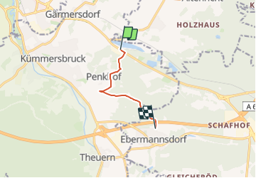
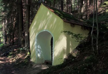
Randonnée A pied de 5,2 km à découvrir à Bavière, Landkreis Amberg-Sulzbach, Kümmersbruck. Cette randonnée est proposée par SityTrail - itinéraires balisés pédestres.
Description
Das Amberg Sulzbacher Land ist die große Urlaubsregion in Ostbayern mit einer vielzahl an aktiven sportlicher Möglichkeiten, aber auch Erholung und Genuss kommen hier nicht zu kurz.
Site web: http://www.wanderwege-bayern.de/luxemburger-weg.html
Localisation
Commentaires
Randonnées à proximité
![Randonnée A pied - Buchbergweg von Amberg - Photo](https://media.geolcdn.com/t/375/260/8707e9ff-a862-4a61-9b94-df9e2102967d.jpeg&format=jpg&maxdim=2)
![A pied A pied](https://static1.geolcdn.com/sitytour/trail-icons/100.png)
A pied
![](/images/other/stat-length.png)
![](https://static1.geolcdn.com/siteimages/upload/files/16400158638029165_repeat_loop_refresh_sync_direction_icon.png)
![Randonnée A pied - Jubiläumswanderweg - Photo](https://media.geolcdn.com/t/375/260/2661fb63-4ef7-425b-9aae-8b0e96b26060.jpeg&format=jpg&maxdim=2)
![A pied A pied](https://static1.geolcdn.com/sitytour/trail-icons/100.png)
![Randonnée A pied - Amberg - Wutschdorf - Photo](https://media.geolcdn.com/t/375/260/13b29c9d-5171-4904-a100-2c86b3d3f643.jpeg&format=jpg&maxdim=2)
![A pied A pied](https://static1.geolcdn.com/sitytour/trail-icons/100.png)
![Randonnée Vélo de route Ebermannsdorf - Amberg à vélo - Photo](https://media.geolcdn.com/t/375/260/da4a772b-9844-41f0-8e0c-92198ea0c1a8.jpg&format=jpg&maxdim=2)
![Vélo de route Vélo de route](https://static1.geolcdn.com/sitytour/trail-icons/201.png)
Vélo de route
![](/images/other/stat-length.png)
![](https://static1.geolcdn.com/siteimages/upload/files/16400158638029165_repeat_loop_refresh_sync_direction_icon.png)