![](/images/other/stat-length.png)
![Randonnée A pied Breitscheid - Rundwanderweg Roßbach 1 - Photo](https://media.geolcdn.com/t/1900/400/f2c11825-d560-4b0a-bc8e-3db9a2b40c70.jpeg&format=pjpeg&maxdim=2)
Rundwanderweg Roßbach 1
SityTrail - itinéraires balisés pédestres
Tous les sentiers balisés d’Europe GUIDE+
![Longueur](/images/other/stat-length.png)
Longueur
17,5 km
![Altitude max](https://static1.geolcdn.com/siteimages/upload/files/1508320355ic_sort_altitude_max_24dp.png)
Altitude max
342 m
![Dénivelé positif](https://static1.geolcdn.com/siteimages/upload/files/1508320355ic_sort_den_pos_24dp.png)
Dénivelé positif
580 m
![Km-Effort](/images/other/stat-length.png)
Km-Effort
25 km
![Altitude min](https://static1.geolcdn.com/siteimages/upload/files/1508320355ic_sort_altitude_min_24dp.png)
Altitude min
114 m
![Dénivelé négatif](https://static1.geolcdn.com/siteimages/upload/files/1508320355ic_sort_den_neg_24dp.png)
Dénivelé négatif
581 m
![Boucle](https://static1.geolcdn.com/siteimages/upload/files/16400158638029165_repeat_loop_refresh_sync_direction_icon.png)
Boucle
Oui
Balise
Date de création :
2022-02-11 17:42:33.799
Dernière modification :
2022-02-11 17:42:33.799
![A pied](https://static1.geolcdn.com/sitytour/trail-icons/100.png)
5h44
Difficulté : Moyen
![Scannez ce code QR pour ouvrir la randonnée dans l'application SityTrail](https://capi.geolives.com/qq0zvz2zws4bq2lad0pu/sitytour/trails/3098400/qr.png?size=200)
Application GPS de randonnée GRATUITE
À propos
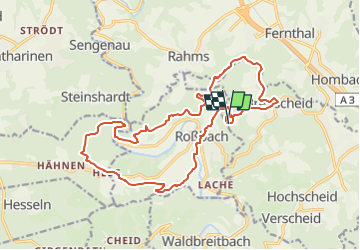
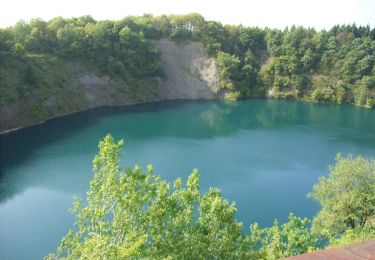
Randonnée A pied de 17,5 km à découvrir à Rhénanie-Palatinat, Landkreis Neuwied, Breitscheid. Cette randonnée est proposée par SityTrail - itinéraires balisés pédestres.
Description
Symbole: Markierung schwarzer Hintergrund, gelbe Zahl
Localisation
Pays :
Allemagne
Région :
Rhénanie-Palatinat
Département/Province :
Landkreis Neuwied
Commune :
Breitscheid
Localité :
Unknown
Départ:(Dec)
Départ:(UTM)
388509 ; 5604057 (32U) N.
Commentaires
Randonnées à proximité
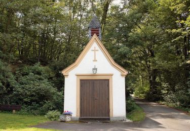
![Randonnée A pied Asbach - [A2] Kapellenweg - Photo](https://media.geolcdn.com/t/375/260/cbe88fbf-390b-407f-8f63-05cd1398c451.jpeg&format=jpg&maxdim=2)
![A pied A pied](https://static1.geolcdn.com/sitytour/trail-icons/100.png)
[A2] Kapellenweg
A pied
Moyen
Asbach,
Rhénanie-Palatinat,
Landkreis Neuwied,
Allemagne
![](/images/other/stat-length.png)
18,8 km | 24 km-effort
5h 26min
![](https://static1.geolcdn.com/siteimages/upload/files/16400158638029165_repeat_loop_refresh_sync_direction_icon.png)
Oui
![Randonnée A pied Hümmerich - Butterpfad - Photo](https://media.geolcdn.com/t/375/260/53665152-448a-4296-9aeb-c73b4f68d052.jpeg&format=jpg&maxdim=2)
![A pied A pied](https://static1.geolcdn.com/sitytour/trail-icons/100.png)
Butterpfad
A pied
Facile
Hümmerich,
Rhénanie-Palatinat,
Landkreis Neuwied,
Allemagne
![](/images/other/stat-length.png)
10,7 km | 13,9 km-effort
3h 9min
![](https://static1.geolcdn.com/siteimages/upload/files/16400158638029165_repeat_loop_refresh_sync_direction_icon.png)
Non
![Randonnée A pied Waldbreitbach - Wäller Tour Bärenkopp - Photo](https://media.geolcdn.com/t/375/260/238fc8e7-6c8b-4adb-b83b-2a3fb088db7a.jpeg&format=jpg&maxdim=2)
![A pied A pied](https://static1.geolcdn.com/sitytour/trail-icons/100.png)
Wäller Tour Bärenkopp
A pied
Facile
Waldbreitbach,
Rhénanie-Palatinat,
Landkreis Neuwied,
Allemagne
![](/images/other/stat-length.png)
11,5 km | 16,2 km-effort
3h 40min
![](https://static1.geolcdn.com/siteimages/upload/files/16400158638029165_repeat_loop_refresh_sync_direction_icon.png)
Oui
![Randonnée A pied Waldbreitbach - Wäller Tour Klosterweg von Rengsdorf nach Waldbreitbach - Photo](https://media.geolcdn.com/t/375/260/238fc8e7-6c8b-4adb-b83b-2a3fb088db7a.jpeg&format=jpg&maxdim=2)
![A pied A pied](https://static1.geolcdn.com/sitytour/trail-icons/100.png)
Wäller Tour Klosterweg von Rengsdorf nach Waldbreitbach
A pied
Moyen
Waldbreitbach,
Rhénanie-Palatinat,
Landkreis Neuwied,
Allemagne
![](/images/other/stat-length.png)
17,7 km | 26 km-effort
5h 47min
![](https://static1.geolcdn.com/siteimages/upload/files/16400158638029165_repeat_loop_refresh_sync_direction_icon.png)
Non
![Randonnée A pied Neustadt (Wied) - [N1] Bertenauer Weg - Photo](https://media.geolcdn.com/t/375/260/23673f5b-8e9e-4aac-bd57-d7ced4e8cded.jpeg&format=jpg&maxdim=2)
![A pied A pied](https://static1.geolcdn.com/sitytour/trail-icons/100.png)
[N1] Bertenauer Weg
A pied
Moyen
Neustadt (Wied),
Rhénanie-Palatinat,
Landkreis Neuwied,
Allemagne
![](/images/other/stat-length.png)
17,6 km | 24 km-effort
5h 23min
![](https://static1.geolcdn.com/siteimages/upload/files/16400158638029165_repeat_loop_refresh_sync_direction_icon.png)
Oui
![Randonnée A pied Vettelschoß - Vettelschoß Rundwanderweg R12 - Photo](https://media.geolcdn.com/t/375/260/b8c16d97-22d2-4b14-825c-d46874d740a8.jpeg&format=jpg&maxdim=2)
![A pied A pied](https://static1.geolcdn.com/sitytour/trail-icons/100.png)
Vettelschoß Rundwanderweg R12
A pied
Facile
Vettelschoß,
Rhénanie-Palatinat,
Landkreis Neuwied,
Allemagne
![](/images/other/stat-length.png)
4,9 km | 7,1 km-effort
1h 37min
![](https://static1.geolcdn.com/siteimages/upload/files/16400158638029165_repeat_loop_refresh_sync_direction_icon.png)
Non
![Randonnée A pied Neustadt (Wied) - N4 - Photo](https://media.geolcdn.com/t/375/260/23673f5b-8e9e-4aac-bd57-d7ced4e8cded.jpeg&format=jpg&maxdim=2)
![A pied A pied](https://static1.geolcdn.com/sitytour/trail-icons/100.png)
N4
A pied
Moyen
Neustadt (Wied),
Rhénanie-Palatinat,
Landkreis Neuwied,
Allemagne
![](/images/other/stat-length.png)
15,9 km | 22 km-effort
5h 4min
![](https://static1.geolcdn.com/siteimages/upload/files/16400158638029165_repeat_loop_refresh_sync_direction_icon.png)
Oui
![Randonnée A pied - Rundweg Strödter Hügel - Photo](https://media.geolcdn.com/t/375/260/ddf8ebbc-05e3-45d3-ad79-f00655b4e165.jpeg&format=jpg&maxdim=2)
![A pied A pied](https://static1.geolcdn.com/sitytour/trail-icons/100.png)
Rundweg Strödter Hügel
A pied
Facile
,
Rhénanie-Palatinat,
Landkreis Neuwied,
Allemagne
![](/images/other/stat-length.png)
6,2 km | 8,4 km-effort
1h 55min
![](https://static1.geolcdn.com/siteimages/upload/files/16400158638029165_repeat_loop_refresh_sync_direction_icon.png)
Oui
![Randonnée A pied Neustadt (Wied) - Erlebnistag Wandern - Photo](https://media.geolcdn.com/t/375/260/23673f5b-8e9e-4aac-bd57-d7ced4e8cded.jpeg&format=jpg&maxdim=2)
![A pied A pied](https://static1.geolcdn.com/sitytour/trail-icons/100.png)
Erlebnistag Wandern
A pied
Facile
Neustadt (Wied),
Rhénanie-Palatinat,
Landkreis Neuwied,
Allemagne
![](/images/other/stat-length.png)
6,6 km | 9 km-effort
2h 2min
![](https://static1.geolcdn.com/siteimages/upload/files/16400158638029165_repeat_loop_refresh_sync_direction_icon.png)
Non