![](/images/other/stat-length.png)
![Randonnée A pied Waldfischbach-Burgalben - Wandern in Clausen C5 - Photo](https://media.geolcdn.com/t/1900/400/65aba17d-e65f-41ac-9aaa-2c06d98c4adb.jpeg&format=pjpeg&maxdim=2)
Wandern in Clausen C5
SityTrail - itinéraires balisés pédestres
Tous les sentiers balisés d’Europe GUIDE+
![Longueur](/images/other/stat-length.png)
Longueur
8,1 km
![Altitude max](https://static1.geolcdn.com/siteimages/upload/files/1508320355ic_sort_altitude_max_24dp.png)
Altitude max
411 m
![Dénivelé positif](https://static1.geolcdn.com/siteimages/upload/files/1508320355ic_sort_den_pos_24dp.png)
Dénivelé positif
267 m
![Km-Effort](/images/other/stat-length.png)
Km-Effort
11,7 km
![Altitude min](https://static1.geolcdn.com/siteimages/upload/files/1508320355ic_sort_altitude_min_24dp.png)
Altitude min
260 m
![Dénivelé négatif](https://static1.geolcdn.com/siteimages/upload/files/1508320355ic_sort_den_neg_24dp.png)
Dénivelé négatif
270 m
![Boucle](https://static1.geolcdn.com/siteimages/upload/files/16400158638029165_repeat_loop_refresh_sync_direction_icon.png)
Boucle
Oui
Balise
Date de création :
2022-02-11 17:40:11.686
Dernière modification :
2022-02-11 17:40:11.686
![A pied](https://static1.geolcdn.com/sitytour/trail-icons/100.png)
2h39
Difficulté : Facile
![Scannez ce code QR pour ouvrir la randonnée dans l'application SityTrail](https://capi.geolives.com/qq0zvz2zws4bq2lad0pu/sitytour/trails/3098333/qr.png?size=200)
Application GPS de randonnée GRATUITE
À propos
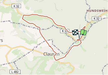
Randonnée A pied de 8,1 km à découvrir à Rhénanie-Palatinat, Südwestpfalz, Waldfischbach-Burgalben. Cette randonnée est proposée par SityTrail - itinéraires balisés pédestres.
Description
Randonnée créée par Kultur und Verkehrsverein Clausen.
Symbole: Blaues Oval Text Weis C5
Site web: http://www.wandern-clausen.de
Localisation
Pays :
Allemagne
Région :
Rhénanie-Palatinat
Département/Province :
Südwestpfalz
Commune :
Waldfischbach-Burgalben
Localité :
Unknown
Départ:(Dec)
Départ:(UTM)
404853 ; 5457856 (32U) N.
Commentaires
Randonnées à proximité
![Randonnée A pied Clausen - Wandern in Clausen C8 Rund um Clausen - Photo](https://media.geolcdn.com/t/375/260/65aba17d-e65f-41ac-9aaa-2c06d98c4adb.jpeg&format=jpg&maxdim=2)
![A pied A pied](https://static1.geolcdn.com/sitytour/trail-icons/100.png)
Wandern in Clausen C8 Rund um Clausen
A pied
Moyen
Clausen,
Rhénanie-Palatinat,
Südwestpfalz,
Allemagne
![](/images/other/stat-length.png)
18 km | 24 km-effort
5h 33min
![](https://static1.geolcdn.com/siteimages/upload/files/16400158638029165_repeat_loop_refresh_sync_direction_icon.png)
Oui
![Randonnée A pied Clausen - Wandern in Clausen C6 - Photo](https://media.geolcdn.com/t/375/260/0114e7e1-ac63-435d-8266-9a3926b8b6e0.jpeg&format=jpg&maxdim=2)
![A pied A pied](https://static1.geolcdn.com/sitytour/trail-icons/100.png)
Wandern in Clausen C6
A pied
Facile
Clausen,
Rhénanie-Palatinat,
Südwestpfalz,
Allemagne
![](/images/other/stat-length.png)
3,9 km | 5,2 km-effort
1h 11min
![](https://static1.geolcdn.com/siteimages/upload/files/16400158638029165_repeat_loop_refresh_sync_direction_icon.png)
Oui
![Randonnée A pied Clausen - Wandern in Clausen C3 Kuhfelsen - Photo](https://media.geolcdn.com/t/375/260/bb27679f-cb33-40dc-8652-0d4b63c8d586.jpeg&format=jpg&maxdim=2)
![A pied A pied](https://static1.geolcdn.com/sitytour/trail-icons/100.png)
Wandern in Clausen C3 Kuhfelsen
A pied
Facile
Clausen,
Rhénanie-Palatinat,
Südwestpfalz,
Allemagne
![](/images/other/stat-length.png)
5,7 km | 7,7 km-effort
1h 44min
![](https://static1.geolcdn.com/siteimages/upload/files/16400158638029165_repeat_loop_refresh_sync_direction_icon.png)
Oui
![Randonnée A pied Clausen - Wandern in Clausen C4 - Photo](https://media.geolcdn.com/t/375/260/65aba17d-e65f-41ac-9aaa-2c06d98c4adb.jpeg&format=jpg&maxdim=2)
![A pied A pied](https://static1.geolcdn.com/sitytour/trail-icons/100.png)
Wandern in Clausen C4
A pied
Facile
Clausen,
Rhénanie-Palatinat,
Südwestpfalz,
Allemagne
![](/images/other/stat-length.png)
6,3 km | 8,5 km-effort
1h 55min
![](https://static1.geolcdn.com/siteimages/upload/files/16400158638029165_repeat_loop_refresh_sync_direction_icon.png)
Oui
![Randonnée A pied Heltersberg - Holzlandweg - Photo](https://media.geolcdn.com/t/375/260/65aba17d-e65f-41ac-9aaa-2c06d98c4adb.jpeg&format=jpg&maxdim=2)
![A pied A pied](https://static1.geolcdn.com/sitytour/trail-icons/100.png)
Holzlandweg
A pied
Très difficile
Heltersberg,
Rhénanie-Palatinat,
Südwestpfalz,
Allemagne
![](/images/other/stat-length.png)
37 km | 51 km-effort
11h 35min
![](https://static1.geolcdn.com/siteimages/upload/files/16400158638029165_repeat_loop_refresh_sync_direction_icon.png)
Oui
![Randonnée A pied Münchweiler an der Rodalb - Münchweiler Höhenwanderweg - Photo](https://media.geolcdn.com/t/375/260/bbd39193-5a66-4d9f-be64-d7d175ff56e8.jpeg&format=jpg&maxdim=2)
![A pied A pied](https://static1.geolcdn.com/sitytour/trail-icons/100.png)
Münchweiler Höhenwanderweg
A pied
Moyen
Münchweiler an der Rodalb,
Rhénanie-Palatinat,
Südwestpfalz,
Allemagne
![](/images/other/stat-length.png)
15,7 km | 22 km-effort
4h 59min
![](https://static1.geolcdn.com/siteimages/upload/files/16400158638029165_repeat_loop_refresh_sync_direction_icon.png)
Oui
![Randonnée A pied Rodalben - Rodalber Felsenwanderweg - Photo](https://media.geolcdn.com/t/375/260/f67160cf-1ac1-4a42-9deb-59a07de4f53a.jpeg&format=jpg&maxdim=2)
![A pied A pied](https://static1.geolcdn.com/sitytour/trail-icons/100.png)
Rodalber Felsenwanderweg
A pied
Difficile
Rodalben,
Rhénanie-Palatinat,
Südwestpfalz,
Allemagne
![](/images/other/stat-length.png)
23 km | 32 km-effort
7h 14min
![](https://static1.geolcdn.com/siteimages/upload/files/16400158638029165_repeat_loop_refresh_sync_direction_icon.png)
Non
![Randonnée A pied Clausen - Wandern in Clausen C12 - Photo](https://media.geolcdn.com/t/375/260/47b4cd41-8db4-43d5-818b-08f79c724e87.jpeg&format=jpg&maxdim=2)
![A pied A pied](https://static1.geolcdn.com/sitytour/trail-icons/100.png)
Wandern in Clausen C12
A pied
Facile
Clausen,
Rhénanie-Palatinat,
Südwestpfalz,
Allemagne
![](/images/other/stat-length.png)
5,5 km | 7,8 km-effort
1h 46min
![](https://static1.geolcdn.com/siteimages/upload/files/16400158638029165_repeat_loop_refresh_sync_direction_icon.png)
Oui
![Randonnée A pied Clausen - Wandern in Clausen C9 - Photo](https://media.geolcdn.com/t/375/260/47b4cd41-8db4-43d5-818b-08f79c724e87.jpeg&format=jpg&maxdim=2)
![A pied A pied](https://static1.geolcdn.com/sitytour/trail-icons/100.png)
Wandern in Clausen C9
A pied
Facile
Clausen,
Rhénanie-Palatinat,
Südwestpfalz,
Allemagne
![](/images/other/stat-length.png)
7,4 km | 10,2 km-effort
2h 19min
![](https://static1.geolcdn.com/siteimages/upload/files/16400158638029165_repeat_loop_refresh_sync_direction_icon.png)
Oui