![](/images/other/stat-length.png)
![Randonnée A pied Dahn - Hohle Felsen-Tour - Photo](https://media.geolcdn.com/t/1900/400/366b092e-8ffc-40eb-a62a-ac1d4458a0f3.jpeg&format=pjpeg&maxdim=2)
Hohle Felsen-Tour
SityTrail - itinéraires balisés pédestres
Tous les sentiers balisés d’Europe GUIDE+
![Longueur](/images/other/stat-length.png)
Longueur
10,6 km
![Altitude max](https://static1.geolcdn.com/siteimages/upload/files/1508320355ic_sort_altitude_max_24dp.png)
Altitude max
453 m
![Dénivelé positif](https://static1.geolcdn.com/siteimages/upload/files/1508320355ic_sort_den_pos_24dp.png)
Dénivelé positif
287 m
![Km-Effort](/images/other/stat-length.png)
Km-Effort
14,4 km
![Altitude min](https://static1.geolcdn.com/siteimages/upload/files/1508320355ic_sort_altitude_min_24dp.png)
Altitude min
225 m
![Dénivelé négatif](https://static1.geolcdn.com/siteimages/upload/files/1508320355ic_sort_den_neg_24dp.png)
Dénivelé négatif
289 m
![Boucle](https://static1.geolcdn.com/siteimages/upload/files/16400158638029165_repeat_loop_refresh_sync_direction_icon.png)
Boucle
Oui
Balise
Date de création :
2022-02-11 17:38:37.275
Dernière modification :
2022-02-11 17:38:37.275
![A pied](https://static1.geolcdn.com/sitytour/trail-icons/100.png)
3h16
Difficulté : Facile
![Scannez ce code QR pour ouvrir la randonnée dans l'application SityTrail](https://capi.geolives.com/qq0zvz2zws4bq2lad0pu/sitytour/trails/3098294/qr.png?size=200)
Application GPS de randonnée GRATUITE
À propos
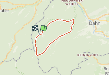
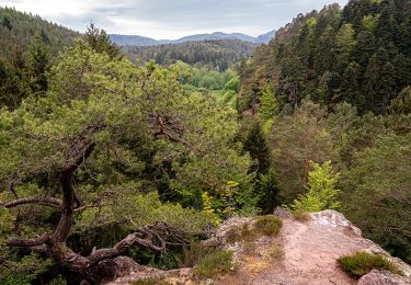
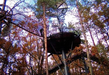
Randonnée A pied de 10,6 km à découvrir à Rhénanie-Palatinat, Südwestpfalz, Dahn. Cette randonnée est proposée par SityTrail - itinéraires balisés pédestres.
Description
Randonnée créée par Tourist Information Dahner Felsenland.
Symbole: roter Felsen auf weißem Grund
Localisation
Pays :
Allemagne
Région :
Rhénanie-Palatinat
Département/Province :
Südwestpfalz
Commune :
Dahn
Localité :
Unknown
Départ:(Dec)
Départ:(UTM)
406480 ; 5443869 (32U) N.
Commentaires
Randonnées à proximité
![Randonnée Marche Dahn - Dahner Felsenpfad - Photo](https://media.geolcdn.com/t/375/260/ext.jpg?maxdim=2&url=https%3A%2F%2Fservices.sitytrail.com%2FGeolivesWS%2FDownloadMedia.ashx%3FTrailID%3D732172%26Media%3Dfix__20170409162639.jpg)
![Marche Marche](https://static1.geolcdn.com/sitytour/trail-icons/101.png)
Dahner Felsenpfad
Marche
Moyen
(2)
Dahn,
Rhénanie-Palatinat,
Südwestpfalz,
Allemagne
![](/images/other/stat-length.png)
13,5 km | 19 km-effort
6h 5min
![](https://static1.geolcdn.com/siteimages/upload/files/16400158638029165_repeat_loop_refresh_sync_direction_icon.png)
Oui
![Randonnée A pied Rumbach - Panoramaweg - Photo](https://media.geolcdn.com/t/375/260/0675f5af-b862-4dd0-9fc4-8b9355fa230b.jpeg&format=jpg&maxdim=2)
![A pied A pied](https://static1.geolcdn.com/sitytour/trail-icons/100.png)
Panoramaweg
A pied
Facile
Rumbach,
Rhénanie-Palatinat,
Südwestpfalz,
Allemagne
![](/images/other/stat-length.png)
4,8 km | 7,2 km-effort
1h 38min
![](https://static1.geolcdn.com/siteimages/upload/files/16400158638029165_repeat_loop_refresh_sync_direction_icon.png)
Oui
![Randonnée A pied Bruchweiler-Bärenbach - Schlangenberg-Tour - Photo](https://media.geolcdn.com/t/375/260/215d3bad-9592-4976-a950-5c40aafe104e.jpeg&format=jpg&maxdim=2)
![A pied A pied](https://static1.geolcdn.com/sitytour/trail-icons/100.png)
Schlangenberg-Tour
A pied
Facile
Bruchweiler-Bärenbach,
Rhénanie-Palatinat,
Südwestpfalz,
Allemagne
![](/images/other/stat-length.png)
6,8 km | 9,3 km-effort
2h 6min
![](https://static1.geolcdn.com/siteimages/upload/files/16400158638029165_repeat_loop_refresh_sync_direction_icon.png)
Oui
![Randonnée A pied Dahn - Kauert-Tour - Photo](https://media.geolcdn.com/t/375/260/05e17897-5601-4f04-bdba-6081bbe05204.jpeg&format=jpg&maxdim=2)
![A pied A pied](https://static1.geolcdn.com/sitytour/trail-icons/100.png)
Kauert-Tour
A pied
Facile
Dahn,
Rhénanie-Palatinat,
Südwestpfalz,
Allemagne
![](/images/other/stat-length.png)
5,5 km | 8 km-effort
1h 48min
![](https://static1.geolcdn.com/siteimages/upload/files/16400158638029165_repeat_loop_refresh_sync_direction_icon.png)
Oui
![Randonnée A pied Dahn - Burg Neudahn-Tour - Photo](https://media.geolcdn.com/t/375/260/75cc7f90-4506-4da8-a264-19e1af7d9017.jpeg&format=jpg&maxdim=2)
![A pied A pied](https://static1.geolcdn.com/sitytour/trail-icons/100.png)
Burg Neudahn-Tour
A pied
Facile
Dahn,
Rhénanie-Palatinat,
Südwestpfalz,
Allemagne
![](/images/other/stat-length.png)
5 km | 6,8 km-effort
1h 33min
![](https://static1.geolcdn.com/siteimages/upload/files/16400158638029165_repeat_loop_refresh_sync_direction_icon.png)
Oui
![Randonnée A pied Dahn - Eyberg-Tour - Photo](https://media.geolcdn.com/t/375/260/2f8d3170-dd0f-4931-acb2-d74a880c97f4.jpeg&format=jpg&maxdim=2)
![A pied A pied](https://static1.geolcdn.com/sitytour/trail-icons/100.png)
Eyberg-Tour
A pied
Facile
Dahn,
Rhénanie-Palatinat,
Südwestpfalz,
Allemagne
![](/images/other/stat-length.png)
11,2 km | 16,7 km-effort
3h 47min
![](https://static1.geolcdn.com/siteimages/upload/files/16400158638029165_repeat_loop_refresh_sync_direction_icon.png)
Oui
![Randonnée A pied Dahn - Kaletschkopf-Tour - Photo](https://media.geolcdn.com/t/375/260/85334ed5-b8e0-46ba-8943-16add4bd40e9.jpeg&format=jpg&maxdim=2)
![A pied A pied](https://static1.geolcdn.com/sitytour/trail-icons/100.png)
Kaletschkopf-Tour
A pied
Facile
Dahn,
Rhénanie-Palatinat,
Südwestpfalz,
Allemagne
![](/images/other/stat-length.png)
9,2 km | 12,8 km-effort
2h 53min
![](https://static1.geolcdn.com/siteimages/upload/files/16400158638029165_repeat_loop_refresh_sync_direction_icon.png)
Oui
![Randonnée A pied Fischbach bei Dahn - Brunnen- und Quellenweg - Photo](https://media.geolcdn.com/t/375/260/680c612f-c742-4793-bbb6-ec2481184dd3.jpeg&format=jpg&maxdim=2)
![A pied A pied](https://static1.geolcdn.com/sitytour/trail-icons/100.png)
Brunnen- und Quellenweg
A pied
Moyen
Fischbach bei Dahn,
Rhénanie-Palatinat,
Südwestpfalz,
Allemagne
![](/images/other/stat-length.png)
21 km | 27 km-effort
6h 14min
![](https://static1.geolcdn.com/siteimages/upload/files/16400158638029165_repeat_loop_refresh_sync_direction_icon.png)
Oui
![Randonnée A pied Dahn - Wolfs-Tour - Photo](https://media.geolcdn.com/t/375/260/d332ae6f-264d-49f3-848b-1c2a22c5d492.jpeg&format=jpg&maxdim=2)
![A pied A pied](https://static1.geolcdn.com/sitytour/trail-icons/100.png)
Wolfs-Tour
A pied
Facile
Dahn,
Rhénanie-Palatinat,
Südwestpfalz,
Allemagne
![](/images/other/stat-length.png)
7,3 km | 10,5 km-effort
2h 22min
![](https://static1.geolcdn.com/siteimages/upload/files/16400158638029165_repeat_loop_refresh_sync_direction_icon.png)
Oui