


3,6 km | 4,6 km-effort
![Randonnée A pied Wetter - [W2] Kleine Wollenbergrunde (Wetschaft Senke) - Photo](https://media.geolcdn.com/t/1900/400/daed682b-00fa-4e8a-8c85-f140ab90c6d6.jpeg&format=pjpeg&maxdim=2)

Tous les sentiers balisés d’Europe GUIDE+


Application GPS de randonnée GRATUITE
 SityTrail
IGN / Instituts géographiques
SityTrail World
Le monde est à vous
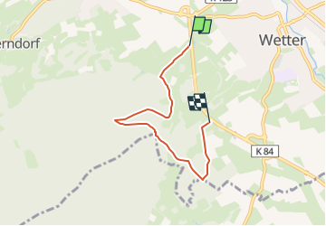
Randonnée A pied de 4,4 km à découvrir à Hesse, Landkreis Marburg-Biedenkopf, Wetter. Cette randonnée est proposée par SityTrail - itinéraires balisés pédestres.
Randonnée créée par Wandcerverein Wetter (Hessen).
Symbole: Gelbe Bezeichnung W2 auf schwarzem Grund
![Randonnée A pied Wetter - [W2] Kleine Wollenbergrunde (Wetschaft Senke) - Photo 1](https://media.geolcdn.com/t/2048/auto/3419ae33-a351-4ed4-8dfd-422e86bb10ef.jpeg&format=jpg&maxdim=0 "Randonnée A pied Wetter - [W2] Kleine Wollenbergrunde (Wetschaft Senke) - Photo 1")
![Randonnée A pied Wetter - [W2] Kleine Wollenbergrunde (Wetschaft Senke) - Photo 2](https://media.geolcdn.com/t/2048/auto/d0fd086e-8ffa-40b7-ba7e-147c2a69c93c.jpeg&format=jpg&maxdim=0 "Randonnée A pied Wetter - [W2] Kleine Wollenbergrunde (Wetschaft Senke) - Photo 2")
![Randonnée A pied Wetter - [W2] Kleine Wollenbergrunde (Wetschaft Senke) - Photo 3](https://media.geolcdn.com/t/2048/auto/87187eed-db0b-44c7-8c33-811d59c1b07c.jpeg&format=jpg&maxdim=0 "Randonnée A pied Wetter - [W2] Kleine Wollenbergrunde (Wetschaft Senke) - Photo 3")
![Randonnée A pied Wetter - [W2] Kleine Wollenbergrunde (Wetschaft Senke) - Photo 4](https://media.geolcdn.com/t/2048/auto/9502c85d-03fc-4215-a2bc-55a8be0da3a1.jpeg&format=jpg&maxdim=0 "Randonnée A pied Wetter - [W2] Kleine Wollenbergrunde (Wetschaft Senke) - Photo 4")
![Randonnée A pied Wetter - [W2] Kleine Wollenbergrunde (Wetschaft Senke) - Photo 5](https://media.geolcdn.com/t/2048/auto/b7bc425d-1bb9-4af0-a728-545d0cc68eb6.jpeg&format=jpg&maxdim=0 "Randonnée A pied Wetter - [W2] Kleine Wollenbergrunde (Wetschaft Senke) - Photo 5")
![Randonnée A pied Wetter - [W2] Kleine Wollenbergrunde (Wetschaft Senke) - Photo 6](https://media.geolcdn.com/t/2048/auto/119bf4be-fc69-4382-afcf-09c7efead5f0.jpeg&format=jpg&maxdim=0 "Randonnée A pied Wetter - [W2] Kleine Wollenbergrunde (Wetschaft Senke) - Photo 6")
![Randonnée A pied Wetter - [W2] Kleine Wollenbergrunde (Wetschaft Senke) - Photo 7](https://media.geolcdn.com/t/2048/auto/daed682b-00fa-4e8a-8c85-f140ab90c6d6.jpeg&format=jpg&maxdim=0 "Randonnée A pied Wetter - [W2] Kleine Wollenbergrunde (Wetschaft Senke) - Photo 7")
![Randonnée A pied Wetter - [W2] Kleine Wollenbergrunde (Wetschaft Senke) - Photo 8](https://media.geolcdn.com/t/2048/auto/8f33c63c-605b-4242-8679-00cbd29587b3.jpeg&format=jpg&maxdim=0 "Randonnée A pied Wetter - [W2] Kleine Wollenbergrunde (Wetschaft Senke) - Photo 8")
A pied
![Randonnée A pied Wetter - [W1] Wollenberg Rundwanderweg - Photo](https://media.geolcdn.com/t/375/260/daed682b-00fa-4e8a-8c85-f140ab90c6d6.jpeg&format=jpg&maxdim=2)
A pied
A pied
A pied