Sonnenbühler Grenzgänger Weg
SityTrail - itinéraires balisés pédestres
Tous les sentiers balisés d’Europe GUIDE+
Longueur
23 km
Altitude max
856 m
Dénivelé positif
572 m
Km-Effort
31 km
Altitude min
709 m
Dénivelé négatif
573 m
Boucle
Oui
Balise
Date de création :
2022-02-11 17:30:50.416
Dernière modification :
2022-02-11 17:30:50.416
6h58
Difficulté : Moyen
Application GPS de randonnée GRATUITE
À propos
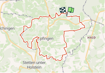
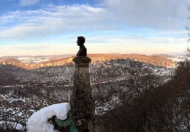
Randonnée A pied de 23 km à découvrir à Bade-Wurtemberg, Landkreis Reutlingen, Gomadingen. Cette randonnée est proposée par SityTrail - itinéraires balisés pédestres.
Description
Randonnée créée par Tourist-Info Undingen Sonnenbühl.
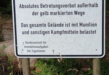
Symbole: Dunkelblauer Grenzstein auf weißem Grund
Site web: http://www.sonnenbuehl.de/data/gaesteNews.php?id=362194
Localisation
Pays :
Allemagne
Région :
Bade-Wurtemberg
Département/Province :
Landkreis Reutlingen
Commune :
Gomadingen
Localité :
Unknown
Départ:(Dec)
Départ:(UTM)
516336 ; 5357226 (32U) N.
Commentaires
Randonnées à proximité
Zugangsweg - Gemeindegrenze (Erpfingen) - Stetten u. H. - Hörschwag - Laucher...
A pied
Facile
Gomadingen,
Bade-Wurtemberg,
Landkreis Reutlingen,
Allemagne
5 km | 6,8 km-effort
1h 32min
Non
Lichtenstein-Kalkofen
A pied
Facile
Gomadingen,
Bade-Wurtemberg,
Landkreis Reutlingen,
Allemagne
4,1 km | 5,1 km-effort
1h 8min
Non
Honau-Lichtenstein
A pied
Facile
Gomadingen,
Bade-Wurtemberg,
Landkreis Reutlingen,
Allemagne
3,5 km | 6,4 km-effort
1h 27min
Non
Rundwanderweg Meidelstetten
A pied
Facile
Gomadingen,
Bade-Wurtemberg,
Landkreis Reutlingen,
Allemagne
7,6 km | 10,3 km-effort
2h 20min
Oui
hochgehträumt
A pied
Facile
Gomadingen,
Bade-Wurtemberg,
Landkreis Reutlingen,
Allemagne
9,6 km | 13,2 km-effort
3h 0min
Non