![](/images/other/stat-length.png)
![Randonnée A pied Nothweiler - Grenzgängerweg / Le sentier à saute frontier - Photo](https://media.geolcdn.com/t/1900/400/0ec53861-ac09-45f6-98f4-4da71460fa1b.jpeg&format=pjpeg&maxdim=2)
Grenzgängerweg / Le sentier à saute frontier
SityTrail - itinéraires balisés pédestres
Tous les sentiers balisés d’Europe GUIDE+
![Longueur](/images/other/stat-length.png)
![Altitude max](https://static1.geolcdn.com/siteimages/upload/files/1508320355ic_sort_altitude_max_24dp.png)
![Dénivelé positif](https://static1.geolcdn.com/siteimages/upload/files/1508320355ic_sort_den_pos_24dp.png)
![Km-Effort](/images/other/stat-length.png)
![Altitude min](https://static1.geolcdn.com/siteimages/upload/files/1508320355ic_sort_altitude_min_24dp.png)
![Dénivelé négatif](https://static1.geolcdn.com/siteimages/upload/files/1508320355ic_sort_den_neg_24dp.png)
![Boucle](https://static1.geolcdn.com/siteimages/upload/files/16400158638029165_repeat_loop_refresh_sync_direction_icon.png)
![A pied](https://static1.geolcdn.com/sitytour/trail-icons/100.png)
2h26
Difficulté : Facile
![Scannez ce code QR pour ouvrir la randonnée dans l'application SityTrail](https://capi.geolives.com/qq0zvz2zws4bq2lad0pu/sitytour/trails/3097725/qr.png?size=200)
Application GPS de randonnée GRATUITE
À propos
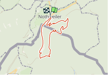
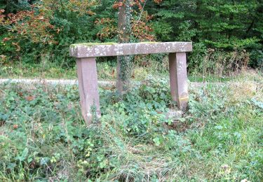
Randonnée A pied de 7,2 km à découvrir à Rhénanie-Palatinat, Südwestpfalz, Nothweiler. Cette randonnée est proposée par SityTrail - itinéraires balisés pédestres.
Description
Symbole: zwei stilisierte blaue Köpfe mit grünem Hut bzw. gelber Baskenmütze auf braunem Grund und in weißem Rahmen, unten links die Wappen von Frankreich und Deutschland und schwarzer Unterschrift "Grenzgängerweg"
Localisation
Commentaires
Randonnées à proximité
![Randonnée Randonnée équestre Wingen - Boucle Loewenstein Hohenbourg Fleckenstein - Photo](https://media.geolcdn.com/t/375/260/70102c74-cde7-4712-ad3f-8ece0b83e7cb.jpg&format=jpg&maxdim=2)
![Randonnée équestre Randonnée équestre](https://static1.geolcdn.com/sitytour/trail-icons/301.png)
Randonnée équestre
![](/images/other/stat-length.png)
![](https://static1.geolcdn.com/siteimages/upload/files/16400158638029165_repeat_loop_refresh_sync_direction_icon.png)
![Randonnée Marche Lembach - Fleckenstein, circuit des 5 châteaux. - Photo](https://media.geolcdn.com/t/375/260/ext.jpg?maxdim=2&url=https%3A%2F%2Fservices.sitytrail.com%2FGeolivesWS%2FDownloadMedia.ashx%3FTrailID%3D364388%26Media%3Dfix__20141120164801.jpg)
![Marche Marche](https://static1.geolcdn.com/sitytour/trail-icons/101.png)
Marche
![](/images/other/stat-length.png)
![](https://static1.geolcdn.com/siteimages/upload/files/16400158638029165_repeat_loop_refresh_sync_direction_icon.png)
![Randonnée A pied Lembach - Anneau jaune - Photo](https://media.geolcdn.com/t/375/260/ca3811e6-33d3-4810-a71b-1526bcfc4047.jpeg&format=jpg&maxdim=2)
![A pied A pied](https://static1.geolcdn.com/sitytour/trail-icons/100.png)
![Randonnée A pied Wingen - Croix rouge - Photo](https://media.geolcdn.com/t/375/260/59ca20a7-ed62-4c6a-9fd9-47494a5cdd7a.jpeg&format=jpg&maxdim=2)
![A pied A pied](https://static1.geolcdn.com/sitytour/trail-icons/100.png)
![Randonnée A pied Wingen - Anneau rouge - Photo](https://media.geolcdn.com/t/375/260/06df198a-1199-44ec-a8d9-2d9a150b410c.jpeg&format=jpg&maxdim=2)
![A pied A pied](https://static1.geolcdn.com/sitytour/trail-icons/100.png)
![Randonnée A pied Lembach - Croix rouge - Photo](https://media.geolcdn.com/t/375/260/8214d6ae-8b08-4cfc-b481-39fdcb8b7805.jpeg&format=jpg&maxdim=2)
![A pied A pied](https://static1.geolcdn.com/sitytour/trail-icons/100.png)
![Randonnée A pied Wingen - Triangle rouge - Photo](https://media.geolcdn.com/t/375/260/8bd60bff-ac8d-4e94-928a-be498e7aa81d.jpeg&format=jpg&maxdim=2)
![A pied A pied](https://static1.geolcdn.com/sitytour/trail-icons/100.png)
A pied
![](/images/other/stat-length.png)
![](https://static1.geolcdn.com/siteimages/upload/files/16400158638029165_repeat_loop_refresh_sync_direction_icon.png)
![Randonnée A pied Lembach - Anneau bleu - Photo](https://media.geolcdn.com/t/375/260/704edbc3-db60-4c8d-8509-777a0364a0c0.jpeg&format=jpg&maxdim=2)
![A pied A pied](https://static1.geolcdn.com/sitytour/trail-icons/100.png)
![Randonnée A pied Nothweiler - Wegelnburg-Tour - Photo](https://media.geolcdn.com/t/375/260/2fad2d9c-a93b-41ab-b1a4-910cffe4363f.jpeg&format=jpg&maxdim=2)
![A pied A pied](https://static1.geolcdn.com/sitytour/trail-icons/100.png)
A pied
![](/images/other/stat-length.png)
![](https://static1.geolcdn.com/siteimages/upload/files/16400158638029165_repeat_loop_refresh_sync_direction_icon.png)