![](/images/other/stat-length.png)
![Randonnée A pied Lemberg - Lemberger Rothenberg-Weg - Photo](https://media.geolcdn.com/t/1900/400/707b9fb7-6276-4f2e-9888-5b78e2108006.jpeg&format=pjpeg&maxdim=2)
Lemberger Rothenberg-Weg
SityTrail - itinéraires balisés pédestres
Tous les sentiers balisés d’Europe GUIDE+
![Longueur](/images/other/stat-length.png)
Longueur
9,4 km
![Altitude max](https://static1.geolcdn.com/siteimages/upload/files/1508320355ic_sort_altitude_max_24dp.png)
Altitude max
430 m
![Dénivelé positif](https://static1.geolcdn.com/siteimages/upload/files/1508320355ic_sort_den_pos_24dp.png)
Dénivelé positif
232 m
![Km-Effort](/images/other/stat-length.png)
Km-Effort
12,6 km
![Altitude min](https://static1.geolcdn.com/siteimages/upload/files/1508320355ic_sort_altitude_min_24dp.png)
Altitude min
325 m
![Dénivelé négatif](https://static1.geolcdn.com/siteimages/upload/files/1508320355ic_sort_den_neg_24dp.png)
Dénivelé négatif
261 m
![Boucle](https://static1.geolcdn.com/siteimages/upload/files/16400158638029165_repeat_loop_refresh_sync_direction_icon.png)
Boucle
Oui
Balise
Date de création :
2022-02-11 17:08:01.559
Dernière modification :
2022-02-11 17:08:01.559
![A pied](https://static1.geolcdn.com/sitytour/trail-icons/100.png)
2h51
Difficulté : Facile
![Scannez ce code QR pour ouvrir la randonnée dans l'application SityTrail](https://capi.geolives.com/qq0zvz2zws4bq2lad0pu/sitytour/trails/3097363/qr.png?size=200)
Application GPS de randonnée GRATUITE
À propos
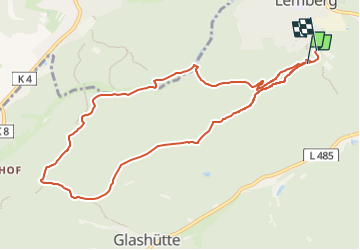
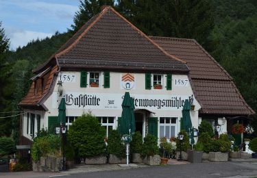
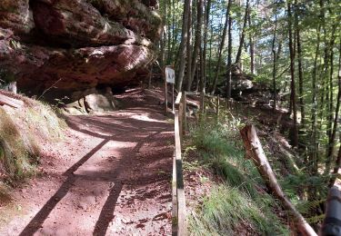
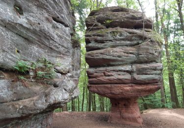
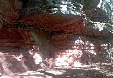
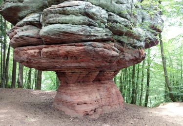
Randonnée A pied de 9,4 km à découvrir à Rhénanie-Palatinat, Südwestpfalz, Lemberg. Cette randonnée est proposée par SityTrail - itinéraires balisés pédestres.
Description
Symbole: Rotes Rechteck mit stilisiertem weißem Gespent im Vordergrund
Localisation
Pays :
Allemagne
Région :
Rhénanie-Palatinat
Département/Province :
Südwestpfalz
Commune :
Lemberg
Localité :
Unknown
Départ:(Dec)
Départ:(UTM)
401928 ; 5446560 (32U) N.
Commentaires
Randonnées à proximité
![Randonnée A pied - Teufelspfad - Photo](https://media.geolcdn.com/t/375/260/72c485d3-1a1c-4db9-8c42-8274cd2b76d3.jpeg&format=jpg&maxdim=2)
![A pied A pied](https://static1.geolcdn.com/sitytour/trail-icons/100.png)
Teufelspfad
A pied
Facile
,
Rhénanie-Palatinat,
Pirmasens,
Allemagne
![](/images/other/stat-length.png)
6,2 km | 8,4 km-effort
1h 54min
![](https://static1.geolcdn.com/siteimages/upload/files/16400158638029165_repeat_loop_refresh_sync_direction_icon.png)
Oui
![Randonnée A pied Münchweiler an der Rodalb - Felsenwaldtour - Photo](https://media.geolcdn.com/t/375/260/27ea1187-bd8b-4476-ae26-5025c4273908.jpeg&format=jpg&maxdim=2)
![A pied A pied](https://static1.geolcdn.com/sitytour/trail-icons/100.png)
Felsenwaldtour
A pied
Facile
Münchweiler an der Rodalb,
Rhénanie-Palatinat,
Südwestpfalz,
Allemagne
![](/images/other/stat-length.png)
13,3 km | 19,1 km-effort
4h 20min
![](https://static1.geolcdn.com/siteimages/upload/files/16400158638029165_repeat_loop_refresh_sync_direction_icon.png)
Oui
![Randonnée A pied Lemberg - Lemberger Graf-Heinrich-Weg - Photo](https://media.geolcdn.com/t/375/260/1a275d3c-a618-441f-91f7-5b44c8024737.jpeg&format=jpg&maxdim=2)
![A pied A pied](https://static1.geolcdn.com/sitytour/trail-icons/100.png)
Lemberger Graf-Heinrich-Weg
A pied
Facile
Lemberg,
Rhénanie-Palatinat,
Südwestpfalz,
Allemagne
![](/images/other/stat-length.png)
11,7 km | 17,4 km-effort
3h 56min
![](https://static1.geolcdn.com/siteimages/upload/files/16400158638029165_repeat_loop_refresh_sync_direction_icon.png)
Oui
![Randonnée Marche Münchweiler an der Rodalb - Felsenwald - Photo](https://media.geolcdn.com/t/375/260/405030d7-97d3-4f5f-ba79-d025ac7a07cb.jpg&format=jpg&maxdim=2)
![Marche Marche](https://static1.geolcdn.com/sitytour/trail-icons/101.png)
Felsenwald
Marche
Difficile
Münchweiler an der Rodalb,
Rhénanie-Palatinat,
Südwestpfalz,
Allemagne
![](/images/other/stat-length.png)
11 km | 15,7 km-effort
3h 34min
![](https://static1.geolcdn.com/siteimages/upload/files/16400158638029165_repeat_loop_refresh_sync_direction_icon.png)
Oui
![Randonnée A pied Dahn - Hohle Felsen-Tour - Photo](https://media.geolcdn.com/t/375/260/366b092e-8ffc-40eb-a62a-ac1d4458a0f3.jpeg&format=jpg&maxdim=2)
![A pied A pied](https://static1.geolcdn.com/sitytour/trail-icons/100.png)
Hohle Felsen-Tour
A pied
Facile
Dahn,
Rhénanie-Palatinat,
Südwestpfalz,
Allemagne
![](/images/other/stat-length.png)
10,6 km | 14,4 km-effort
3h 16min
![](https://static1.geolcdn.com/siteimages/upload/files/16400158638029165_repeat_loop_refresh_sync_direction_icon.png)
Oui
![Randonnée Marche Münchweiler an der Rodalb - Pirmasens - Felsenwald - Photo](https://media.geolcdn.com/t/375/260/5baf6c00-a6a3-46f6-9a28-4727ebd10360.jpg&format=jpg&maxdim=2)
![Marche Marche](https://static1.geolcdn.com/sitytour/trail-icons/101.png)
Pirmasens - Felsenwald
Marche
Moyen
Münchweiler an der Rodalb,
Rhénanie-Palatinat,
Südwestpfalz,
Allemagne
![](/images/other/stat-length.png)
14,2 km | 20 km-effort
4h 48min
![](https://static1.geolcdn.com/siteimages/upload/files/16400158638029165_repeat_loop_refresh_sync_direction_icon.png)
Oui
![Randonnée Marche Lemberg - lemberger rothenbergerweg - Photo](https://media.geolcdn.com/t/375/260/cddecaaf-a040-463d-9719-ab6f1d8c2ec4.jpg&format=jpg&maxdim=2)
![Marche Marche](https://static1.geolcdn.com/sitytour/trail-icons/101.png)
lemberger rothenbergerweg
Marche
Moyen
Lemberg,
Rhénanie-Palatinat,
Südwestpfalz,
Allemagne
![](/images/other/stat-length.png)
10,7 km | 14,3 km-effort
3h 12min
![](https://static1.geolcdn.com/siteimages/upload/files/16400158638029165_repeat_loop_refresh_sync_direction_icon.png)
Oui
![Randonnée Marche - Pirmasens - Felsenwald - Photo](https://media.geolcdn.com/t/375/260/3ba6f11f-1f49-416d-9c9b-6b8c23ffe125.jpg&format=jpg&maxdim=2)
![Marche Marche](https://static1.geolcdn.com/sitytour/trail-icons/101.png)
Pirmasens - Felsenwald
Marche
Moyen
,
Rhénanie-Palatinat,
Pirmasens,
Allemagne
![](/images/other/stat-length.png)
15,5 km | 22 km-effort
4h 29min
![](https://static1.geolcdn.com/siteimages/upload/files/16400158638029165_repeat_loop_refresh_sync_direction_icon.png)
Non
![Randonnée V.T.T. Lemberg - eppenbrunn - Photo](https://media.geolcdn.com/t/375/260/ext.jpg?maxdim=2&url=https%3A%2F%2Fstatic1.geolcdn.com%2Fsiteimages%2Fupload%2Ffiles%2F1524743154velo.jpg)
![V.T.T. V.T.T.](https://static1.geolcdn.com/sitytour/trail-icons/202.png)
eppenbrunn
V.T.T.
Très difficile
Lemberg,
Rhénanie-Palatinat,
Südwestpfalz,
Allemagne
![](/images/other/stat-length.png)
43 km | 58 km-effort
3h 39min
![](https://static1.geolcdn.com/siteimages/upload/files/16400158638029165_repeat_loop_refresh_sync_direction_icon.png)
Oui