Randonnée A pied Waidhaus - RW: Waidhaus – Hoher Brand – Waidhaus - Photo

RW: Waidhaus – Hoher Brand – Waidhaus

Tous les sentiers balisés d’Europe GUIDE+

© OpenStreetMap contributors
Longueur
Longueur
7,9 km
Altitude max
Altitude max
551 m
Dénivelé positif
Dénivelé positif
102 m
Km-Effort
Km-Effort  
9,3 km
Altitude min
Altitude min
491 m
Dénivelé négatif
Dénivelé négatif
103 m
Boucle
Boucle
Oui
Balise
Balise
Date de création :
2022-02-11 17:00:55.38
Dernière modification :
2022-02-11 17:00:55.38

(0 Avis)

A pied
A pied
2h06
Difficulté : Facile

Scannez ce code QR pour ouvrir la randonnée dans l'application SityTrail

Application GPS de randonnée GRATUITE

Logo SityTrail SityTrail

IGN / Instituts géographiques

Télécharger SityTrail sur l'App Store Télécharger SityTrail sur Google Play

Logo SityTrail SityTrail World

Le monde est à vous

Télécharger SityTrail sur l'App Store Télécharger SityTrail sur Google Play Télécharger SityTrail sur Huawei AppGallery

À propos

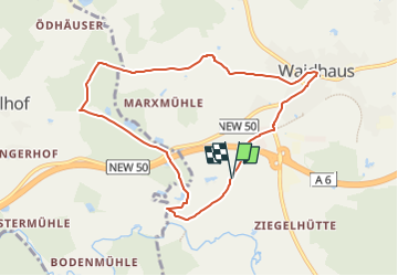
Randonnée A pied de 7,9 km à découvrir à Bavière, Landkreis Neustadt an der Waldnaab, Waidhaus. Cette randonnée est proposée par SityTrail - itinéraires balisés pédestres.

Description

Randonnée créée par Oberpfälzer Waldverein.

Symbole: Rote Diagonale, von links unten nach rechts oben, auf weißem Grund


Site web: http://owv-waidhaus.de/?page_id=156

Profil altimétrique

Photos

Localisation

Pays :
Allemagne
Région :
Bavière
Département/Province :
Landkreis Neustadt an der Waldnaab
Commune :
Waidhaus
Localité :
Unknown
Départ:(UTM)
318211 ; 5500759 (33U) N.

Randonnées à proximité

Randonnée A pied Waidhaus - RW: Waidhaus – Ulrichsberg – Waidhaus - Photo
A pied
GUIDE+

A pied

Facile
Waidhaus, Bavière, Landkreis Neustadt an der Waldnaab, Allemagne
9,5 km | 12 km-effort
2h 43min
Non
Randonnée A pied Waidhaus - RW: Waidhaus – Frankenreuth – Grenzübergang – Waidhaus - Photo
A pied
GUIDE+

A pied

Facile
Waidhaus, Bavière, Landkreis Neustadt an der Waldnaab, Allemagne
7,1 km | 8,3 km-effort
1h 52min
Oui
Randonnée A pied Waidhaus - RW: Waidhaus – Hagendorf – Waidhaus - Photo
A pied
GUIDE+

A pied

Facile
Waidhaus, Bavière, Landkreis Neustadt an der Waldnaab, Allemagne
6,8 km | 9 km-effort
2h 2min
Oui


Fermer
Mes abonnements