![](/images/other/stat-length.png)
![Randonnée A pied Waidhaus - RW: Waidhaus – Frankenreuth – Grenzübergang – Waidhaus - Photo](https://media.geolcdn.com/t/1900/400/6ce2a4a2-b98b-47b9-9d44-2a10fe1ed3c3.jpeg&format=pjpeg&maxdim=2)
RW: Waidhaus – Frankenreuth – Grenzübergang – Waidhaus
SityTrail - itinéraires balisés pédestres
Tous les sentiers balisés d’Europe GUIDE+
![Longueur](/images/other/stat-length.png)
Longueur
7,1 km
![Altitude max](https://static1.geolcdn.com/siteimages/upload/files/1508320355ic_sort_altitude_max_24dp.png)
Altitude max
542 m
![Dénivelé positif](https://static1.geolcdn.com/siteimages/upload/files/1508320355ic_sort_den_pos_24dp.png)
Dénivelé positif
87 m
![Km-Effort](/images/other/stat-length.png)
Km-Effort
8,3 km
![Altitude min](https://static1.geolcdn.com/siteimages/upload/files/1508320355ic_sort_altitude_min_24dp.png)
Altitude min
503 m
![Dénivelé négatif](https://static1.geolcdn.com/siteimages/upload/files/1508320355ic_sort_den_neg_24dp.png)
Dénivelé négatif
91 m
![Boucle](https://static1.geolcdn.com/siteimages/upload/files/16400158638029165_repeat_loop_refresh_sync_direction_icon.png)
Boucle
Oui
Balise
Date de création :
2022-02-11 17:00:43.252
Dernière modification :
2022-02-11 17:00:43.252
![A pied](https://static1.geolcdn.com/sitytour/trail-icons/100.png)
1h52
Difficulté : Facile
![Scannez ce code QR pour ouvrir la randonnée dans l'application SityTrail](https://capi.geolives.com/qq0zvz2zws4bq2lad0pu/sitytour/trails/3097163/qr.png?size=200)
Application GPS de randonnée GRATUITE
À propos
Randonnée A pied de 7,1 km à découvrir à Bavière, Landkreis Neustadt an der Waldnaab, Waidhaus. Cette randonnée est proposée par SityTrail - itinéraires balisés pédestres.
Description
Randonnée créée par Oberpfälzer Waldverein.
Symbole: Rote s Dreieck auf weißem Grund
Site web: http://owv-waidhaus.de/?page_id=156
Localisation
Pays :
Allemagne
Région :
Bavière
Département/Province :
Landkreis Neustadt an der Waldnaab
Commune :
Waidhaus
Localité :
Unknown
Départ:(Dec)
Départ:(UTM)
321154 ; 5503261 (33U) N.
Commentaires
Randonnées à proximité
![Randonnée A pied Hošťka - Vyhlídková naučná stezka - Photo](https://media.geolcdn.com/t/375/260/de5fa688-c472-4e93-ac35-43eb0e649d0c.jpeg&format=jpg&maxdim=2)
![A pied A pied](https://static1.geolcdn.com/sitytour/trail-icons/100.png)
Vyhlídková naučná stezka
A pied
Facile
Hošťka,
Jihozápad,
Plzeňský kraj,
République Tchèque
![](/images/other/stat-length.png)
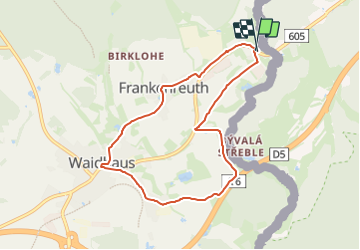
13,6 km | 16,8 km-effort
3h 48min
![](https://static1.geolcdn.com/siteimages/upload/files/16400158638029165_repeat_loop_refresh_sync_direction_icon.png)
Oui
![Randonnée A pied Rozvadov - [Ž] Rybničná -;Pod ovčím kopcem - Photo](https://media.geolcdn.com/t/375/260/cbd477a6-9e51-410c-896f-089efa643184.jpeg&format=jpg&maxdim=2)
![A pied A pied](https://static1.geolcdn.com/sitytour/trail-icons/100.png)
[Ž] Rybničná -;Pod ovčím kopcem
A pied
Facile
Rozvadov,
Jihozápad,
Plzeňský kraj,
République Tchèque
![](/images/other/stat-length.png)
9,1 km | 12,4 km-effort
2h 48min
![](https://static1.geolcdn.com/siteimages/upload/files/16400158638029165_repeat_loop_refresh_sync_direction_icon.png)
Non
![Randonnée A pied Waidhaus - RW: Waidhaus – Ulrichsberg – Waidhaus - Photo](https://media.geolcdn.com/t/375/260/6ce2a4a2-b98b-47b9-9d44-2a10fe1ed3c3.jpeg&format=jpg&maxdim=2)
![A pied A pied](https://static1.geolcdn.com/sitytour/trail-icons/100.png)
RW: Waidhaus – Ulrichsberg – Waidhaus
A pied
Facile
Waidhaus,
Bavière,
Landkreis Neustadt an der Waldnaab,
Allemagne
![](/images/other/stat-length.png)
9,5 km | 12 km-effort
2h 43min
![](https://static1.geolcdn.com/siteimages/upload/files/16400158638029165_repeat_loop_refresh_sync_direction_icon.png)
Non
![Randonnée A pied Waidhaus - RW: Waidhaus – Hagendorf – Waidhaus - Photo](https://media.geolcdn.com/t/375/260/6ce2a4a2-b98b-47b9-9d44-2a10fe1ed3c3.jpeg&format=jpg&maxdim=2)
![A pied A pied](https://static1.geolcdn.com/sitytour/trail-icons/100.png)
RW: Waidhaus – Hagendorf – Waidhaus
A pied
Facile
Waidhaus,
Bavière,
Landkreis Neustadt an der Waldnaab,
Allemagne
![](/images/other/stat-length.png)
6,8 km | 9 km-effort
2h 2min
![](https://static1.geolcdn.com/siteimages/upload/files/16400158638029165_repeat_loop_refresh_sync_direction_icon.png)
Oui
![Randonnée A pied Waidhaus - RW: Waidhaus – Hoher Brand – Waidhaus - Photo](https://media.geolcdn.com/t/375/260/6ce2a4a2-b98b-47b9-9d44-2a10fe1ed3c3.jpeg&format=jpg&maxdim=2)
![A pied A pied](https://static1.geolcdn.com/sitytour/trail-icons/100.png)
RW: Waidhaus – Hoher Brand – Waidhaus
A pied
Facile
Waidhaus,
Bavière,
Landkreis Neustadt an der Waldnaab,
Allemagne
![](/images/other/stat-length.png)
7,9 km | 9,3 km-effort
2h 6min
![](https://static1.geolcdn.com/siteimages/upload/files/16400158638029165_repeat_loop_refresh_sync_direction_icon.png)
Oui