![](/images/other/stat-length.png)
![Randonnée A pied Auen - VitalTour: Willigisweg - Photo](https://media.geolcdn.com/t/1900/400/ext.pjpeg?maxdim=2&url=https%3A%2F%2Fmedia.geolcdn.com%2Ff%2F19704de6-91bb-4ac7-b58e-2d11c20f3f15.jpeg)
VitalTour: Willigisweg
SityTrail - itinéraires balisés pédestres
Tous les sentiers balisés d’Europe PRO
![Longueur](/images/other/stat-length.png)
Longueur
19,6 km
![Altitude max](https://static1.geolcdn.com/siteimages/upload/files/1508320355ic_sort_altitude_max_24dp.png)
Altitude max
428 m
![Dénivelé positif](https://static1.geolcdn.com/siteimages/upload/files/1508320355ic_sort_den_pos_24dp.png)
Dénivelé positif
573 m
![Km-Effort](/images/other/stat-length.png)
Km-Effort
27 km
![Altitude min](https://static1.geolcdn.com/siteimages/upload/files/1508320355ic_sort_altitude_min_24dp.png)
Altitude min
226 m
![Dénivelé négatif](https://static1.geolcdn.com/siteimages/upload/files/1508320355ic_sort_den_neg_24dp.png)
Dénivelé négatif
584 m
![Boucle](https://static1.geolcdn.com/siteimages/upload/files/16400158638029165_repeat_loop_refresh_sync_direction_icon.png)
Boucle
Oui
Balise
Date de création :
2022-02-11 16:47:39.882
Dernière modification :
2022-02-11 16:47:39.882
![A pied](https://static1.geolcdn.com/sitytour/trail-icons/100.png)
6h11
Difficulté : Moyen
![Scannez ce code QR pour ouvrir la randonnée dans l'application SityTrail](https://capi.geolives.com/qq0zvz2zws4bq2lad0pu/sitytour/trails/3096862/qr.png?size=200)
Application GPS de randonnée GRATUITE
À propos
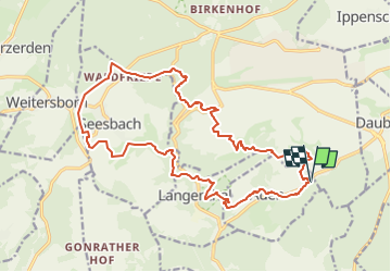
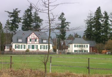
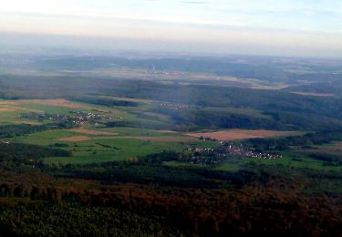
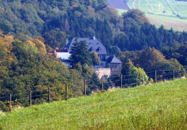
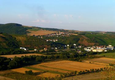
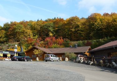
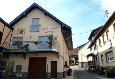
Randonnée A pied de 19,6 km à découvrir à Rhénanie-Palatinat, Landkreis Bad Kreuznach, Auen. Cette randonnée est proposée par SityTrail - itinéraires balisés pédestres.
Description
Randonnée créée par Kur- und Touristinformation, Bahnhofstr. 4, 55566 Bad Sobernheim.
Localisation
Pays :
Allemagne
Région :
Rhénanie-Palatinat
Département/Province :
Landkreis Bad Kreuznach
Commune :
Auen
Localité :
Unknown
Départ:(Dec)
Départ:(UTM)
400082 ; 5521048 (32U) N.
Commentaires
Randonnées à proximité
![Randonnée A pied Auen - Auen 3 - Photo](https://media.geolcdn.com/t/375/260/ext.jpg?maxdim=2&url=https%3A%2F%2Fmedia.geolcdn.com%2Ff%2F69d50de2-4efd-4935-8881-47a5ff2036c2.jpeg)
![A pied A pied](https://static1.geolcdn.com/sitytour/trail-icons/100.png)
Auen 3
A pied
Facile
Auen,
Rhénanie-Palatinat,
Landkreis Bad Kreuznach,
Allemagne
![](/images/other/stat-length.png)
3,5 km | 5,5 km-effort
1h 14min
![](https://static1.geolcdn.com/siteimages/upload/files/16400158638029165_repeat_loop_refresh_sync_direction_icon.png)
Non
![Randonnée A pied Bad Sobernheim - Entenpfuhl 2 - Photo](https://media.geolcdn.com/t/375/260/ext.jpg?maxdim=2&url=https%3A%2F%2Fmedia.geolcdn.com%2Ff%2Fee05e713-9c76-4f6e-8850-6a4c313cd94a.jpeg)
![A pied A pied](https://static1.geolcdn.com/sitytour/trail-icons/100.png)
Entenpfuhl 2
A pied
Facile
Bad Sobernheim,
Rhénanie-Palatinat,
Landkreis Bad Kreuznach,
Allemagne
![](/images/other/stat-length.png)
6,8 km | 8,8 km-effort
1h 59min
![](https://static1.geolcdn.com/siteimages/upload/files/16400158638029165_repeat_loop_refresh_sync_direction_icon.png)
Oui
![Randonnée A pied Bad Sobernheim - Jäger-aus-Kurpfalz-Weg (Entenpfuhl 3) - Photo](https://media.geolcdn.com/t/375/260/ext.jpg?maxdim=2&url=https%3A%2F%2Fmedia.geolcdn.com%2Ff%2Fda96cadf-4d54-49da-a249-f2e1c0732feb.jpeg)
![A pied A pied](https://static1.geolcdn.com/sitytour/trail-icons/100.png)
Jäger-aus-Kurpfalz-Weg (Entenpfuhl 3)
A pied
Facile
Bad Sobernheim,
Rhénanie-Palatinat,
Landkreis Bad Kreuznach,
Allemagne
![](/images/other/stat-length.png)
10,5 km | 13,7 km-effort
3h 6min
![](https://static1.geolcdn.com/siteimages/upload/files/16400158638029165_repeat_loop_refresh_sync_direction_icon.png)
Oui
![Randonnée A pied Allenfeld - Vitaltour Schlossweg - Photo](https://media.geolcdn.com/t/375/260/ext.jpg?maxdim=2&url=https%3A%2F%2Fmedia.geolcdn.com%2Ff%2F253dfd44-bb22-49df-ab2f-6ee82a205adb.jpeg)
![A pied A pied](https://static1.geolcdn.com/sitytour/trail-icons/100.png)
Vitaltour Schlossweg
A pied
Facile
Allenfeld,
Rhénanie-Palatinat,
Landkreis Bad Kreuznach,
Allemagne
![](/images/other/stat-length.png)
9,4 km | 13 km-effort
2h 57min
![](https://static1.geolcdn.com/siteimages/upload/files/16400158638029165_repeat_loop_refresh_sync_direction_icon.png)
Oui
![Randonnée A pied Allenfeld - Vitaltour Um die Wüstung - Photo](https://media.geolcdn.com/t/375/260/ext.jpg?maxdim=2&url=https%3A%2F%2Fmedia.geolcdn.com%2Ff%2F253dfd44-bb22-49df-ab2f-6ee82a205adb.jpeg)
![A pied A pied](https://static1.geolcdn.com/sitytour/trail-icons/100.png)
Vitaltour Um die Wüstung
A pied
Facile
Allenfeld,
Rhénanie-Palatinat,
Landkreis Bad Kreuznach,
Allemagne
![](/images/other/stat-length.png)
14,7 km | 19,9 km-effort
4h 31min
![](https://static1.geolcdn.com/siteimages/upload/files/16400158638029165_repeat_loop_refresh_sync_direction_icon.png)
Oui
![Randonnée A pied Merxheim - Winchendeller Weiher - Photo](https://media.geolcdn.com/t/375/260/ext.jpg?maxdim=2&url=https%3A%2F%2Fmedia.geolcdn.com%2Ff%2F45873ccc-9648-45ff-a9a9-5533583d2f9e.jpeg)
![A pied A pied](https://static1.geolcdn.com/sitytour/trail-icons/100.png)
Winchendeller Weiher
A pied
Facile
Merxheim,
Rhénanie-Palatinat,
Landkreis Bad Kreuznach,
Allemagne
![](/images/other/stat-length.png)
8,8 km | 12,1 km-effort
2h 44min
![](https://static1.geolcdn.com/siteimages/upload/files/16400158638029165_repeat_loop_refresh_sync_direction_icon.png)
Oui
![Randonnée A pied Seesbach - Soonwaldsteig - Zuweg_Seesbach 2 - Photo](https://media.geolcdn.com/t/375/260/ext.jpg?maxdim=2&url=https%3A%2F%2Fmedia.geolcdn.com%2Ff%2F3b7766d3-2d72-43e0-b76a-acc8ef77e466.jpeg)
![A pied A pied](https://static1.geolcdn.com/sitytour/trail-icons/100.png)
Soonwaldsteig - Zuweg_Seesbach 2
A pied
Facile
Seesbach,
Rhénanie-Palatinat,
Landkreis Bad Kreuznach,
Allemagne
![](/images/other/stat-length.png)
3,7 km | 5,8 km-effort
1h 18min
![](https://static1.geolcdn.com/siteimages/upload/files/16400158638029165_repeat_loop_refresh_sync_direction_icon.png)
Non
![Randonnée A pied Bockenau - DVV Durch die Bockenauer Schweiz - Photo](https://media.geolcdn.com/t/375/260/ext.jpg?maxdim=2&url=https%3A%2F%2Fmedia.geolcdn.com%2Ff%2F9b5f90d9-8edc-411f-ab48-434abab1f26f.jpeg)
![A pied A pied](https://static1.geolcdn.com/sitytour/trail-icons/100.png)
DVV Durch die Bockenauer Schweiz
A pied
Facile
Bockenau,
Rhénanie-Palatinat,
Landkreis Bad Kreuznach,
Allemagne
![](/images/other/stat-length.png)
9,5 km | 12,2 km-effort
2h 46min
![](https://static1.geolcdn.com/siteimages/upload/files/16400158638029165_repeat_loop_refresh_sync_direction_icon.png)
Oui
![Randonnée A pied Weiler bei Monzingen - Heiligenberg W1 - Photo](https://media.geolcdn.com/t/375/260/ext.jpg?maxdim=2&url=https%3A%2F%2Fmedia.geolcdn.com%2Ff%2F2f46d65e-ee94-40cb-b559-9e596845cff3.jpeg)
![A pied A pied](https://static1.geolcdn.com/sitytour/trail-icons/100.png)
Heiligenberg W1
A pied
Facile
Weiler bei Monzingen,
Rhénanie-Palatinat,
Landkreis Bad Kreuznach,
Allemagne
![](/images/other/stat-length.png)
3,3 km | 4,6 km-effort
1h 2min
![](https://static1.geolcdn.com/siteimages/upload/files/16400158638029165_repeat_loop_refresh_sync_direction_icon.png)
Non