![](/images/other/stat-length.png)
![Randonnée A pied Sittensen - Nordpfad 'Börde Sittensen' - Photo](https://media.geolcdn.com/t/1900/400/fa0744ae-2f2d-41ed-b4ec-a52e9f07804f.jpeg&format=pjpeg&maxdim=2)
Nordpfad 'Börde Sittensen'
SityTrail - itinéraires balisés pédestres
Tous les sentiers balisés d’Europe GUIDE+
![Longueur](/images/other/stat-length.png)
![Altitude max](https://static1.geolcdn.com/siteimages/upload/files/1508320355ic_sort_altitude_max_24dp.png)
![Dénivelé positif](https://static1.geolcdn.com/siteimages/upload/files/1508320355ic_sort_den_pos_24dp.png)
![Km-Effort](/images/other/stat-length.png)
![Altitude min](https://static1.geolcdn.com/siteimages/upload/files/1508320355ic_sort_altitude_min_24dp.png)
![Dénivelé négatif](https://static1.geolcdn.com/siteimages/upload/files/1508320355ic_sort_den_neg_24dp.png)
![Boucle](https://static1.geolcdn.com/siteimages/upload/files/16400158638029165_repeat_loop_refresh_sync_direction_icon.png)
![A pied](https://static1.geolcdn.com/sitytour/trail-icons/100.png)
3h28
Difficulté : Facile
![Scannez ce code QR pour ouvrir la randonnée dans l'application SityTrail](https://capi.geolives.com/qq0zvz2zws4bq2lad0pu/sitytour/trails/3096861/qr.png?size=200)
Application GPS de randonnée GRATUITE
À propos
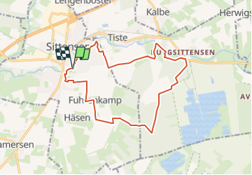
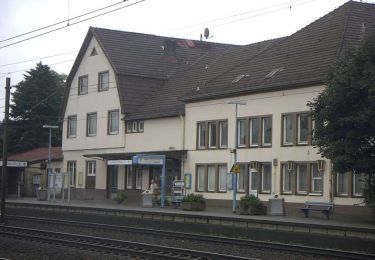
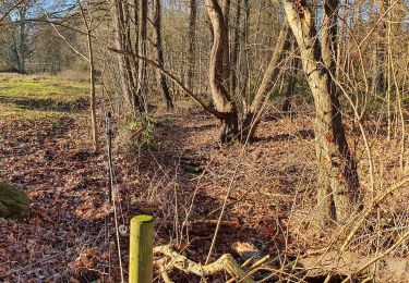
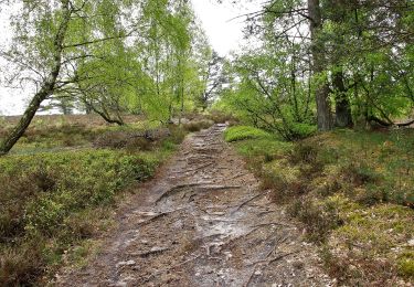
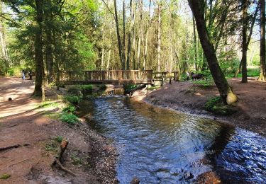
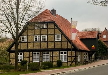
Randonnée A pied de 14,1 km à découvrir à Basse-Saxe, Rotenbourg-sur-la-Wümme (arrondissement), Sittensen. Cette randonnée est proposée par SityTrail - itinéraires balisés pédestres.
Description
Randonnée créée par Touristikverband Landkreis Rotenburg.
Symbole: weißes, stilisiertes N auf orangenem Grund, darunter der Name des Weges
Localisation
Commentaires
Randonnées à proximité
![Randonnée A pied Zeven - Nordpfad Zevener Geest - Photo](https://media.geolcdn.com/t/375/260/dce0007f-a1bf-4dc8-a679-5225b0ed62c6.jpeg&format=jpg&maxdim=2)
![A pied A pied](https://static1.geolcdn.com/sitytour/trail-icons/100.png)
A pied
![](/images/other/stat-length.png)
![](https://static1.geolcdn.com/siteimages/upload/files/16400158638029165_repeat_loop_refresh_sync_direction_icon.png)
![Randonnée A pied Fintel - Nordpfad 'Osterberg' - Photo](https://media.geolcdn.com/t/375/260/28547453-06cb-4181-b4e8-52ee5b02b014.jpeg&format=jpg&maxdim=2)
![A pied A pied](https://static1.geolcdn.com/sitytour/trail-icons/100.png)
A pied
![](/images/other/stat-length.png)
![](https://static1.geolcdn.com/siteimages/upload/files/16400158638029165_repeat_loop_refresh_sync_direction_icon.png)
![Randonnée A pied Rotenburg - Nordpfad 'Wümmeniederung' - Photo](https://media.geolcdn.com/t/375/260/ecb4495f-cac4-46f7-bdd5-217aad6a1dfe.jpeg&format=jpg&maxdim=2)
![A pied A pied](https://static1.geolcdn.com/sitytour/trail-icons/100.png)
A pied
![](/images/other/stat-length.png)
![](https://static1.geolcdn.com/siteimages/upload/files/16400158638029165_repeat_loop_refresh_sync_direction_icon.png)
![Randonnée A pied Scheeßel - Nordpfad Kirchsteg-Moore-Bäche - Photo](https://media.geolcdn.com/t/375/260/273d364c-a347-4ced-a181-59ba300bf3b4.jpeg&format=jpg&maxdim=2)
![A pied A pied](https://static1.geolcdn.com/sitytour/trail-icons/100.png)
A pied
![](/images/other/stat-length.png)
![](https://static1.geolcdn.com/siteimages/upload/files/16400158638029165_repeat_loop_refresh_sync_direction_icon.png)
![Randonnée A pied Wenzendorf - Wander-Verbindung Buchholz-Drestedt - Photo](https://media.geolcdn.com/t/375/260/bb3fd8e6-f608-4a37-a249-d1229ce7e5b3.jpeg&format=jpg&maxdim=2)
![A pied A pied](https://static1.geolcdn.com/sitytour/trail-icons/100.png)
A pied
![](/images/other/stat-length.png)
![](https://static1.geolcdn.com/siteimages/upload/files/16400158638029165_repeat_loop_refresh_sync_direction_icon.png)
![Randonnée A pied Neu Wulmstorf - Wander-Tour Wulmstorfer Heide - Photo](https://media.geolcdn.com/t/375/260/adb25b3f-c64e-4c16-8bf9-34cbe415c4a7.jpeg&format=jpg&maxdim=2)
![A pied A pied](https://static1.geolcdn.com/sitytour/trail-icons/100.png)
A pied
![](/images/other/stat-length.png)
![](https://static1.geolcdn.com/siteimages/upload/files/16400158638029165_repeat_loop_refresh_sync_direction_icon.png)
![Randonnée A pied Appel - Wander-Verbindung Buchholz-Appel - Photo](https://media.geolcdn.com/t/375/260/e64f0e1c-968b-4fd0-ab64-f88c5c353e04.jpeg&format=jpg&maxdim=2)
![A pied A pied](https://static1.geolcdn.com/sitytour/trail-icons/100.png)
A pied
![](/images/other/stat-length.png)
![](https://static1.geolcdn.com/siteimages/upload/files/16400158638029165_repeat_loop_refresh_sync_direction_icon.png)
![Randonnée A pied Drestedt - Wanderweg Drestedt - Hollenstedt - Photo](https://media.geolcdn.com/t/375/260/0d571203-2379-4aaf-aa27-7978abdcd9bd.jpeg&format=jpg&maxdim=2)
![A pied A pied](https://static1.geolcdn.com/sitytour/trail-icons/100.png)
A pied
![](/images/other/stat-length.png)
![](https://static1.geolcdn.com/siteimages/upload/files/16400158638029165_repeat_loop_refresh_sync_direction_icon.png)
![Randonnée A pied Hollenstedt - Wander-Tour Este West - Photo](https://media.geolcdn.com/t/375/260/0bb5555d-857e-4370-8326-5875e6399571.jpeg&format=jpg&maxdim=2)
![A pied A pied](https://static1.geolcdn.com/sitytour/trail-icons/100.png)
A pied
![](/images/other/stat-length.png)
![](https://static1.geolcdn.com/siteimages/upload/files/16400158638029165_repeat_loop_refresh_sync_direction_icon.png)