![](/images/other/stat-length.png)
![Randonnée A pied Feilbingert - Panoramaweg Feilbingert - Photo](https://media.geolcdn.com/t/1900/400/3028b17c-2474-46fe-897b-70e08a40e661.jpeg&format=pjpeg&maxdim=2)
Panoramaweg Feilbingert
SityTrail - itinéraires balisés pédestres
Tous les sentiers balisés d’Europe GUIDE+
![Longueur](/images/other/stat-length.png)
![Altitude max](https://static1.geolcdn.com/siteimages/upload/files/1508320355ic_sort_altitude_max_24dp.png)
![Dénivelé positif](https://static1.geolcdn.com/siteimages/upload/files/1508320355ic_sort_den_pos_24dp.png)
![Km-Effort](/images/other/stat-length.png)
![Altitude min](https://static1.geolcdn.com/siteimages/upload/files/1508320355ic_sort_altitude_min_24dp.png)
![Dénivelé négatif](https://static1.geolcdn.com/siteimages/upload/files/1508320355ic_sort_den_neg_24dp.png)
![Boucle](https://static1.geolcdn.com/siteimages/upload/files/16400158638029165_repeat_loop_refresh_sync_direction_icon.png)
![A pied](https://static1.geolcdn.com/sitytour/trail-icons/100.png)
2h39
Difficulté : Facile
![Scannez ce code QR pour ouvrir la randonnée dans l'application SityTrail](https://capi.geolives.com/qq0zvz2zws4bq2lad0pu/sitytour/trails/3096841/qr.png?size=200)
Application GPS de randonnée GRATUITE
À propos
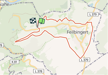
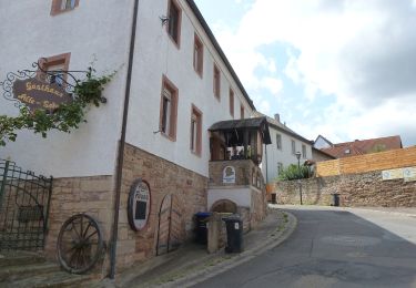
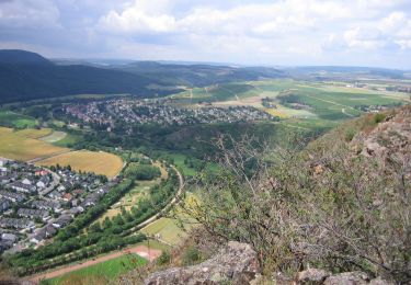
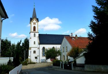
Randonnée A pied de 9,4 km à découvrir à Rhénanie-Palatinat, Landkreis Bad Kreuznach, Feilbingert. Cette randonnée est proposée par SityTrail - itinéraires balisés pédestres.
Description
Randonnée créée par Verkehrs- und Verschönerungsverein Feilbingert e.V..
Symbole: Naturfarbenes Blechschild mit ausgestanzten Buchstaben "Panoramaweg"
Localisation
Commentaires
Randonnées à proximité
![Randonnée A pied Bad Kreuznach - VITALtour Ebernburg - Photo](https://media.geolcdn.com/t/375/260/11454e8e-f7ad-45a5-b1fd-c3959b4ed60d.jpeg&format=jpg&maxdim=2)
![A pied A pied](https://static1.geolcdn.com/sitytour/trail-icons/100.png)
A pied
![](/images/other/stat-length.png)
![](https://static1.geolcdn.com/siteimages/upload/files/16400158638029165_repeat_loop_refresh_sync_direction_icon.png)
![Randonnée A pied Bad Kreuznach - CLASSICtour Ebernburg - Photo](https://media.geolcdn.com/t/375/260/367c4f69-37b0-4930-a976-e0fba27c0ac4.jpeg&format=jpg&maxdim=2)
![A pied A pied](https://static1.geolcdn.com/sitytour/trail-icons/100.png)
A pied
![](/images/other/stat-length.png)
![](https://static1.geolcdn.com/siteimages/upload/files/16400158638029165_repeat_loop_refresh_sync_direction_icon.png)
![Randonnée A pied Bad Kreuznach - INTROtour Ebernburg - Photo](https://media.geolcdn.com/t/375/260/9cdfcaed-0f29-406a-a8d3-be07df56a775.jpeg&format=jpg&maxdim=2)
![A pied A pied](https://static1.geolcdn.com/sitytour/trail-icons/100.png)
A pied
![](/images/other/stat-length.png)
![](https://static1.geolcdn.com/siteimages/upload/files/16400158638029165_repeat_loop_refresh_sync_direction_icon.png)
![Randonnée A pied Bad Kreuznach - VITALtour Rotenfels - Photo](https://media.geolcdn.com/t/375/260/a3e43b83-cfd7-4092-b126-d0afe63d2a12.jpeg&format=jpg&maxdim=2)
![A pied A pied](https://static1.geolcdn.com/sitytour/trail-icons/100.png)
A pied
![](/images/other/stat-length.png)
![](https://static1.geolcdn.com/siteimages/upload/files/16400158638029165_repeat_loop_refresh_sync_direction_icon.png)
![Randonnée A pied Bad Kreuznach - INTROtour Rotenfels - Photo](https://media.geolcdn.com/t/375/260/d397efa7-486d-47ff-aab7-88c64a0ac604.jpeg&format=jpg&maxdim=2)
![A pied A pied](https://static1.geolcdn.com/sitytour/trail-icons/100.png)
A pied
![](/images/other/stat-length.png)
![](https://static1.geolcdn.com/siteimages/upload/files/16400158638029165_repeat_loop_refresh_sync_direction_icon.png)
![Randonnée A pied Feilbingert - VITALtour Geheimnisvoller Lemberg - Photo](https://media.geolcdn.com/t/375/260/46e1e849-3c9f-48a4-a463-d1b10e5aa9c3.jpeg&format=jpg&maxdim=2)
![A pied A pied](https://static1.geolcdn.com/sitytour/trail-icons/100.png)
A pied
![](/images/other/stat-length.png)
![](https://static1.geolcdn.com/siteimages/upload/files/16400158638029165_repeat_loop_refresh_sync_direction_icon.png)
![Randonnée A pied Waldböckelheim - Waldböckelheimer](https://media.geolcdn.com/t/375/260/43693554-d6fe-47e5-bb3d-b573d93b751d.jpeg&format=jpg&maxdim=2)
![A pied A pied](https://static1.geolcdn.com/sitytour/trail-icons/100.png)
A pied
![](/images/other/stat-length.png)
![](https://static1.geolcdn.com/siteimages/upload/files/16400158638029165_repeat_loop_refresh_sync_direction_icon.png)
![Randonnée A pied Odernheim am Glan - Humbergtour - Photo](https://media.geolcdn.com/t/375/260/7e5cda45-3ad4-4bc2-8422-5cd9a3d419e8.jpeg&format=jpg&maxdim=2)
![A pied A pied](https://static1.geolcdn.com/sitytour/trail-icons/100.png)
A pied
![](/images/other/stat-length.png)
![](https://static1.geolcdn.com/siteimages/upload/files/16400158638029165_repeat_loop_refresh_sync_direction_icon.png)
![Randonnée A pied Odernheim am Glan - Rundwanderweg Odernheim 1 - Photo](https://media.geolcdn.com/t/375/260/7e5cda45-3ad4-4bc2-8422-5cd9a3d419e8.jpeg&format=jpg&maxdim=2)
![A pied A pied](https://static1.geolcdn.com/sitytour/trail-icons/100.png)
A pied
![](/images/other/stat-length.png)
![](https://static1.geolcdn.com/siteimages/upload/files/16400158638029165_repeat_loop_refresh_sync_direction_icon.png)