Randonnée A pied Rhens - Traumpfad Wolfsdelle - Photo

Tous les sentiers balisés d’Europe PRO

© OpenStreetMap contributors
Longueur
Longueur
10,3 km
Altitude max
Altitude max
292 m
Dénivelé positif
Dénivelé positif
332 m
Km-Effort
Km-Effort  
14,7 km
Altitude min
Altitude min
86 m
Dénivelé négatif
Dénivelé négatif
339 m
Boucle
Boucle
Oui
Balise
Balise
Date de création :
2022-02-11 16:42:06.628
Dernière modification :
2022-02-11 16:42:06.628

(0 Avis)

A pied
A pied
3h20
Difficulté : Facile

Scannez ce code QR pour ouvrir la randonnée dans l'application SityTrail

Application GPS de randonnée GRATUITE

Logo SityTrail SityTrail

IGN / Instituts géographiques

Télécharger SityTrail sur l'App Store Télécharger SityTrail sur Google Play

Logo SityTrail SityTrail World

Le monde est à vous

Télécharger SityTrail sur l'App Store Télécharger SityTrail sur Google Play Télécharger SityTrail sur Huawei AppGallery

À propos

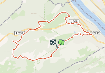
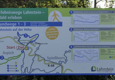
Randonnée A pied de 10,3 km à découvrir à Rhénanie-Palatinat, Landkreis Mayen-Koblenz, Rhens. Cette randonnée est proposée par SityTrail - itinéraires balisés pédestres.

Description

Der Traumpfad Wolfsdelle führt Sie auf historischen Supren ab Koblenz, Mayen, Bendorf zum Königsstuhl mit Ausblicken ins Rheintal, den Hunsrück und Taunus.

Site web: https://www.traumpfade.info/traumpfade-rhein-mosel-eifel/rhein/wolfsdelle/

Photos

Localisation

Pays :
Allemagne
Région :
Rhénanie-Palatinat
Département/Province :
Landkreis Mayen-Koblenz
Commune :
Rhens
Localité :
Unknown
Départ:(UTM)
399889 ; 5570179 (32U) N.

Randonnées à proximité

Randonnée A pied Lahnstein - Rundwanderweg A - Photo
A pied
PRO

A pied

Facile
Lahnstein, Rhénanie-Palatinat, Rhein-Lahn-Kreis, Allemagne
4,2 km | 6 km-effort
1h 21min
Oui
Randonnée A pied Lahnstein - Rundwanderweg B - Photo
A pied
PRO

A pied

Facile
Lahnstein, Rhénanie-Palatinat, Rhein-Lahn-Kreis, Allemagne
7,1 km | 10,1 km-effort
2h 18min
Oui
Randonnée A pied Osterspai - Rheinsteig-Zuweg Osterspai - Photo
A pied
PRO

A pied

Facile
Osterspai, Rhénanie-Palatinat, Rhein-Lahn-Kreis, Allemagne
3,6 km | 4,4 km-effort
59min
Non
Randonnée A pied Lahnstein - Rheinsteig-Exkursion Spießborner Grillhütte - Photo
A pied
PRO

A pied

Facile
Lahnstein, Rhénanie-Palatinat, Rhein-Lahn-Kreis, Allemagne
3,8 km | 4,8 km-effort
1h 5min
Non
Randonnée A pied Lahnstein - Wanderweg Forsthaus-Weg FH - Photo
A pied
PRO

A pied

Facile
Lahnstein, Rhénanie-Palatinat, Rhein-Lahn-Kreis, Allemagne
4,2 km | 5,9 km-effort
1h 20min
Non
Randonnée A pied Lahnstein - Rundwanderweg A2 - Photo
A pied
PRO

A pied

Facile
Lahnstein, Rhénanie-Palatinat, Rhein-Lahn-Kreis, Allemagne
3 km | 4,8 km-effort
1h 5min
Non
Randonnée A pied Lahnstein - Rundwanderweg B1 - Photo
A pied
PRO

A pied

Facile
Lahnstein, Rhénanie-Palatinat, Rhein-Lahn-Kreis, Allemagne
3 km | 4,5 km-effort
1h 1min
Non
Randonnée A pied Lahnstein - Rundwanderweg D1 - Photo
A pied
PRO

A pied

Facile
Lahnstein, Rhénanie-Palatinat, Rhein-Lahn-Kreis, Allemagne
3,7 km | 4,4 km-effort
1h 0min
Oui
Randonnée A pied Lahnstein - Rundwanderweg F4 - Photo
A pied
PRO

A pied

Facile
Lahnstein, Rhénanie-Palatinat, Rhein-Lahn-Kreis, Allemagne
4 km | 5,8 km-effort
1h 19min
Oui


Fermer
Mes abonnements