


13,7 km | 17,6 km-effort

Tous les sentiers balisés d’Europe GUIDE+


Application GPS de randonnée GRATUITE
 SityTrail
IGN / Instituts géographiques
SityTrail World
Le monde est à vous
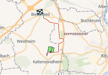
Randonnée A pied de 5,4 km à découvrir à Bavière, Landkreis Kitzingen, Biebelried. Cette randonnée est proposée par SityTrail - itinéraires balisés pédestres.
Randonnée créée par Archäologisches Spessartprojekt.
Symbole: Gelbes EU-Schiffchen auf blauem Grund
Site web: https://www.spessartprojekt.de/wordpress/?page_id=10123
 "
data-pinterest-text="Pin it"
data-tweet-text="share on twitter"
data-facebook-share-url="https://www.sitytrail.com/fr/trails/3096583-biebelried--kulturweg-biebelried-xdas-steinerne-herz-mainfrankensx/?photo=1#lg=1&slide=1"
data-twitter-share-url="https://www.sitytrail.com/fr/trails/3096583-biebelried--kulturweg-biebelried-xdas-steinerne-herz-mainfrankensx/?photo=1#lg=1&slide=1"
data-googleplus-share-url="https://www.sitytrail.com/fr/trails/3096583-biebelried--kulturweg-biebelried-xdas-steinerne-herz-mainfrankensx/?photo=1#lg=1&slide=1"
data-pinterest-share-url="https://www.sitytrail.com/fr/trails/3096583-biebelried--kulturweg-biebelried-xdas-steinerne-herz-mainfrankensx/?photo=1#lg=1&slide=1">
"
data-pinterest-text="Pin it"
data-tweet-text="share on twitter"
data-facebook-share-url="https://www.sitytrail.com/fr/trails/3096583-biebelried--kulturweg-biebelried-xdas-steinerne-herz-mainfrankensx/?photo=1#lg=1&slide=1"
data-twitter-share-url="https://www.sitytrail.com/fr/trails/3096583-biebelried--kulturweg-biebelried-xdas-steinerne-herz-mainfrankensx/?photo=1#lg=1&slide=1"
data-googleplus-share-url="https://www.sitytrail.com/fr/trails/3096583-biebelried--kulturweg-biebelried-xdas-steinerne-herz-mainfrankensx/?photo=1#lg=1&slide=1"
data-pinterest-share-url="https://www.sitytrail.com/fr/trails/3096583-biebelried--kulturweg-biebelried-xdas-steinerne-herz-mainfrankensx/?photo=1#lg=1&slide=1">
 "
data-pinterest-text="Pin it"
data-tweet-text="share on twitter"
data-facebook-share-url="https://www.sitytrail.com/fr/trails/3096583-biebelried--kulturweg-biebelried-xdas-steinerne-herz-mainfrankensx/?photo=2#lg=1&slide=2"
data-twitter-share-url="https://www.sitytrail.com/fr/trails/3096583-biebelried--kulturweg-biebelried-xdas-steinerne-herz-mainfrankensx/?photo=2#lg=1&slide=2"
data-googleplus-share-url="https://www.sitytrail.com/fr/trails/3096583-biebelried--kulturweg-biebelried-xdas-steinerne-herz-mainfrankensx/?photo=2#lg=1&slide=2"
data-pinterest-share-url="https://www.sitytrail.com/fr/trails/3096583-biebelried--kulturweg-biebelried-xdas-steinerne-herz-mainfrankensx/?photo=2#lg=1&slide=2">
"
data-pinterest-text="Pin it"
data-tweet-text="share on twitter"
data-facebook-share-url="https://www.sitytrail.com/fr/trails/3096583-biebelried--kulturweg-biebelried-xdas-steinerne-herz-mainfrankensx/?photo=2#lg=1&slide=2"
data-twitter-share-url="https://www.sitytrail.com/fr/trails/3096583-biebelried--kulturweg-biebelried-xdas-steinerne-herz-mainfrankensx/?photo=2#lg=1&slide=2"
data-googleplus-share-url="https://www.sitytrail.com/fr/trails/3096583-biebelried--kulturweg-biebelried-xdas-steinerne-herz-mainfrankensx/?photo=2#lg=1&slide=2"
data-pinterest-share-url="https://www.sitytrail.com/fr/trails/3096583-biebelried--kulturweg-biebelried-xdas-steinerne-herz-mainfrankensx/?photo=2#lg=1&slide=2">

A pied

A pied
A pied

A pied
A pied
A pied
A pied
A pied

A pied