Randonnée A pied Bad Laasphe - Ilsetalpfad - Photo

Tous les sentiers balisés d’Europe PRO

© OpenStreetMap contributors
Longueur
Longueur
16,6 km
Altitude max
Altitude max
613 m
Dénivelé positif
Dénivelé positif
485 m
Km-Effort
Km-Effort  
23 km
Altitude min
Altitude min
395 m
Dénivelé négatif
Dénivelé négatif
486 m
Boucle
Boucle
Oui
Balise
Balise
Date de création :
2022-02-11 16:35:34.01
Dernière modification :
2022-02-11 16:35:34.01

(0 Avis)

A pied
A pied
5h14
Difficulté : Moyen

Scannez ce code QR pour ouvrir la randonnée dans l'application SityTrail

Application GPS de randonnée GRATUITE

Logo SityTrail SityTrail

IGN / Instituts géographiques

Télécharger SityTrail sur l'App Store Télécharger SityTrail sur Google Play

Logo SityTrail SityTrail World

Le monde est à vous

Télécharger SityTrail sur l'App Store Télécharger SityTrail sur Google Play Télécharger SityTrail sur Huawei AppGallery

À propos

Randonnée A pied de 16,6 km à découvrir à Rhénanie-du-Nord-Westphalie, Kreis Siegen-Wittgenstein, Bad Laasphe. Cette randonnée est proposée par SityTrail - itinéraires balisés pédestres.

Description

Randonnée créée par Rothaarsteigverein e.V..

Symbole: Auf der linken Seite liegendes weißes R auf schwarzem Grund

Photos

Localisation

Pays :
Allemagne
Région :
Rhénanie-du-Nord-Westphalie
Département/Province :
Kreis Siegen-Wittgenstein
Commune :
Bad Laasphe
Localité :
Unknown
Départ:(UTM)
452248 ; 5643010 (32U) N.

Randonnées à proximité

Randonnée A pied Bad Laasphe - Saßmannshausen Rundweg A3 - Photo
A pied
PRO

A pied

Facile
Bad Laasphe, Rhénanie-du-Nord-Westphalie, Kreis Siegen-Wittgenstein, Allemagne
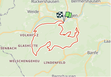
6,8 km | 10,2 km-effort
2h 18min
Non
Randonnée A pied Bad Laasphe - östlicher Rothaarsteig-Zuweg Feudingen - Photo
A pied
PRO

A pied

Facile
Bad Laasphe, Rhénanie-du-Nord-Westphalie, Kreis Siegen-Wittgenstein, Allemagne
6,6 km | 9,2 km-effort
2h 6min
Non


Fermer
Mes abonnements