![](/images/other/stat-length.png)
![Randonnée A pied Gladenbach - Georg Ludwig Hartwig Weg - Photo](https://media.geolcdn.com/t/1900/400/ext.pjpeg?maxdim=2&url=https%3A%2F%2Fmedia.geolcdn.com%2Ff%2Fc4926b3e-ab7c-4a04-8b7a-27da92e0b938.jpeg)
Georg Ludwig Hartwig Weg
SityTrail - itinéraires balisés pédestres
Tous les sentiers balisés d’Europe PRO
![Longueur](/images/other/stat-length.png)
Longueur
9,8 km
![Altitude max](https://static1.geolcdn.com/siteimages/upload/files/1508320355ic_sort_altitude_max_24dp.png)
Altitude max
369 m
![Dénivelé positif](https://static1.geolcdn.com/siteimages/upload/files/1508320355ic_sort_den_pos_24dp.png)
Dénivelé positif
244 m
![Km-Effort](/images/other/stat-length.png)
Km-Effort
13 km
![Altitude min](https://static1.geolcdn.com/siteimages/upload/files/1508320355ic_sort_altitude_min_24dp.png)
Altitude min
249 m
![Dénivelé négatif](https://static1.geolcdn.com/siteimages/upload/files/1508320355ic_sort_den_neg_24dp.png)
Dénivelé négatif
242 m
![Boucle](https://static1.geolcdn.com/siteimages/upload/files/16400158638029165_repeat_loop_refresh_sync_direction_icon.png)
Boucle
Oui
Balise
Date de création :
2022-02-11 16:22:36.215
Dernière modification :
2022-02-11 16:22:36.215
![A pied](https://static1.geolcdn.com/sitytour/trail-icons/100.png)
2h57
Difficulté : Facile
![Scannez ce code QR pour ouvrir la randonnée dans l'application SityTrail](https://capi.geolives.com/qq0zvz2zws4bq2lad0pu/sitytour/trails/3096225/qr.png?size=200)
Application GPS de randonnée GRATUITE
À propos
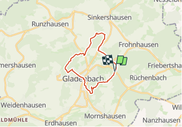
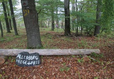
Randonnée A pied de 9,8 km à découvrir à Hesse, Landkreis Marburg-Biedenkopf, Gladenbach. Cette randonnée est proposée par SityTrail - itinéraires balisés pédestres.
Description
Randonnée créée par Oberhessischer Gebirgsverein.
Localisation
Pays :
Allemagne
Région :
Hesse
Département/Province :
Landkreis Marburg-Biedenkopf
Commune :
Gladenbach
Localité :
Unknown
Départ:(Dec)
Départ:(UTM)
472006 ; 5624570 (32U) N.
Commentaires
Randonnées à proximité
![Randonnée A pied Gladenbach - Extratour Postraubroute - Photo](https://media.geolcdn.com/t/375/260/ext.jpg?maxdim=2&url=https%3A%2F%2Fmedia.geolcdn.com%2Ff%2F2e5e3f6a-716e-4e97-af2a-b06bf33fb9c3.jpeg)
![A pied A pied](https://static1.geolcdn.com/sitytour/trail-icons/100.png)
Extratour Postraubroute
A pied
Facile
Gladenbach,
Hesse,
Landkreis Marburg-Biedenkopf,
Allemagne
![](/images/other/stat-length.png)
11,1 km | 15 km-effort
3h 23min
![](https://static1.geolcdn.com/siteimages/upload/files/16400158638029165_repeat_loop_refresh_sync_direction_icon.png)
Oui
![Randonnée A pied Gladenbach - [G7] - Rundweg Gladenbach - Mornshausen - Hüttenmühle - Subach - Teufelsberg - Koppe - Mornshausen - Gladenbach - Photo](https://media.geolcdn.com/t/375/260/ext.jpg?maxdim=2&url=https%3A%2F%2Fmedia.geolcdn.com%2Ff%2F2e5e3f6a-716e-4e97-af2a-b06bf33fb9c3.jpeg)
![A pied A pied](https://static1.geolcdn.com/sitytour/trail-icons/100.png)
[G7] - Rundweg Gladenbach - Mornshausen - Hüttenmühle - Subach - Teufelsberg ...
A pied
Facile
Gladenbach,
Hesse,
Landkreis Marburg-Biedenkopf,
Allemagne
![](/images/other/stat-length.png)
5,9 km | 8,3 km-effort
1h 52min
![](https://static1.geolcdn.com/siteimages/upload/files/16400158638029165_repeat_loop_refresh_sync_direction_icon.png)
Non
![Randonnée A pied Gladenbach - [G4] - Rundweg Gladenbach - Reithalle - alter Pflanzengarten - Rachelshausen - Kehlnbach - Kehlnbachtal - Gladenbach - Photo](https://media.geolcdn.com/t/375/260/ext.jpg?maxdim=2&url=https%3A%2F%2Fmedia.geolcdn.com%2Ff%2F5102141e-d951-49fc-98e6-521cd239ef3d.jpeg)
![A pied A pied](https://static1.geolcdn.com/sitytour/trail-icons/100.png)
[G4] - Rundweg Gladenbach - Reithalle - alter Pflanzengarten - Rachelshausen ...
A pied
Facile
Gladenbach,
Hesse,
Landkreis Marburg-Biedenkopf,
Allemagne
![](/images/other/stat-length.png)
6 km | 7,5 km-effort
1h 42min
![](https://static1.geolcdn.com/siteimages/upload/files/16400158638029165_repeat_loop_refresh_sync_direction_icon.png)
Oui
![Randonnée A pied Gladenbach - [G12] - Rundweg Gladenbach - Ruine Blankenstein - Kehlnbach - Römershausen - Rachelshausen - Runzhausen - Schutzhütte Kehlnbach - Gladenbach - Photo](https://media.geolcdn.com/t/375/260/ext.jpg?maxdim=2&url=https%3A%2F%2Fmedia.geolcdn.com%2Ff%2F9a55fbee-7b56-4a3a-8921-e1e04f3645be.jpeg)
![A pied A pied](https://static1.geolcdn.com/sitytour/trail-icons/100.png)
[G12] - Rundweg Gladenbach - Ruine Blankenstein - Kehlnbach - Römershausen - ...
A pied
Facile
Gladenbach,
Hesse,
Landkreis Marburg-Biedenkopf,
Allemagne
![](/images/other/stat-length.png)
12,5 km | 16,9 km-effort
3h 50min
![](https://static1.geolcdn.com/siteimages/upload/files/16400158638029165_repeat_loop_refresh_sync_direction_icon.png)
Oui
![Randonnée A pied Gladenbach - [G11] - Rundweg Gladenbach - Ammenhausen - Friebertshausen - Wolfskapelle - Altes Forsthaus Rüchenbach - Ammenhausen - Gladenbach - Photo](https://media.geolcdn.com/t/375/260/ext.jpg?maxdim=2&url=https%3A%2F%2Fmedia.geolcdn.com%2Ff%2F74d81b5d-74eb-484a-be77-6338fb44592d.jpeg)
![A pied A pied](https://static1.geolcdn.com/sitytour/trail-icons/100.png)
[G11] - Rundweg Gladenbach - Ammenhausen - Friebertshausen - Wolfskapelle - A...
A pied
Facile
Gladenbach,
Hesse,
Landkreis Marburg-Biedenkopf,
Allemagne
![](/images/other/stat-length.png)
8,9 km | 11,6 km-effort
2h 38min
![](https://static1.geolcdn.com/siteimages/upload/files/16400158638029165_repeat_loop_refresh_sync_direction_icon.png)
Oui
![Randonnée A pied Gladenbach - [G1] - Rund um Gladenbach - Photo](https://media.geolcdn.com/t/375/260/ext.jpg?maxdim=2&url=https%3A%2F%2Fmedia.geolcdn.com%2Ff%2Fc4926b3e-ab7c-4a04-8b7a-27da92e0b938.jpeg)
![A pied A pied](https://static1.geolcdn.com/sitytour/trail-icons/100.png)
[G1] - Rund um Gladenbach
A pied
Facile
Gladenbach,
Hesse,
Landkreis Marburg-Biedenkopf,
Allemagne
![](/images/other/stat-length.png)
9,4 km | 12,5 km-effort
2h 50min
![](https://static1.geolcdn.com/siteimages/upload/files/16400158638029165_repeat_loop_refresh_sync_direction_icon.png)
Oui
![Randonnée A pied Gladenbach - [G2] - Rundweg Gladenbach - Bruchmühle - Sportplatz Erdhausen - Koppe - Mornshausen - Gladenbach - Photo](https://media.geolcdn.com/t/375/260/ext.jpg?maxdim=2&url=https%3A%2F%2Fmedia.geolcdn.com%2Ff%2F0190eb51-e3e1-4683-bae1-1b15eaf6b48c.jpeg)
![A pied A pied](https://static1.geolcdn.com/sitytour/trail-icons/100.png)
[G2] - Rundweg Gladenbach - Bruchmühle - Sportplatz Erdhausen - Koppe - Morns...
A pied
Facile
Gladenbach,
Hesse,
Landkreis Marburg-Biedenkopf,
Allemagne
![](/images/other/stat-length.png)
8,3 km | 12,2 km-effort
2h 46min
![](https://static1.geolcdn.com/siteimages/upload/files/16400158638029165_repeat_loop_refresh_sync_direction_icon.png)
Oui
![Randonnée A pied Gladenbach - Sebastian-Kneipp-Weg - Photo](https://media.geolcdn.com/t/375/260/ext.jpg?maxdim=2&url=https%3A%2F%2Fmedia.geolcdn.com%2Ff%2F0a35ed60-9ddb-4fe4-8e15-a49b4596d783.jpeg)
![A pied A pied](https://static1.geolcdn.com/sitytour/trail-icons/100.png)
Sebastian-Kneipp-Weg
A pied
Facile
Gladenbach,
Hesse,
Landkreis Marburg-Biedenkopf,
Allemagne
![](/images/other/stat-length.png)
6,4 km | 8,3 km-effort
1h 52min
![](https://static1.geolcdn.com/siteimages/upload/files/16400158638029165_repeat_loop_refresh_sync_direction_icon.png)
Oui
![Randonnée A pied Gladenbach - Extratour Gladenbacher Berglandring - Photo](https://media.geolcdn.com/t/375/260/ext.jpg?maxdim=2&url=https%3A%2F%2Fmedia.geolcdn.com%2Ff%2F86167cad-c56c-4737-863f-484cf9f75f6d.jpeg)
![A pied A pied](https://static1.geolcdn.com/sitytour/trail-icons/100.png)
Extratour Gladenbacher Berglandring
A pied
Facile
Gladenbach,
Hesse,
Landkreis Marburg-Biedenkopf,
Allemagne
![](/images/other/stat-length.png)
8,4 km | 12 km-effort
2h 44min
![](https://static1.geolcdn.com/siteimages/upload/files/16400158638029165_repeat_loop_refresh_sync_direction_icon.png)
Non