![](/images/other/stat-length.png)
![Randonnée A pied Haidmühle - Rundweg 2 Bischofsreut-Marchhäuser-Schnellenzipf - Photo](https://media.geolcdn.com/t/1900/400/ext.pjpeg?maxdim=2&url=https%3A%2F%2Fstatic1.geolcdn.com%2Fsiteimages%2Fupload%2Ffiles%2F1545311037marcheuse_200dpi.jpg)
Rundweg 2 Bischofsreut-Marchhäuser-Schnellenzipf
SityTrail - itinéraires balisés pédestres
Tous les sentiers balisés d’Europe GUIDE+
![Longueur](/images/other/stat-length.png)
Longueur
3,9 km
![Altitude max](https://static1.geolcdn.com/siteimages/upload/files/1508320355ic_sort_altitude_max_24dp.png)
Altitude max
968 m
![Dénivelé positif](https://static1.geolcdn.com/siteimages/upload/files/1508320355ic_sort_den_pos_24dp.png)
Dénivelé positif
158 m
![Km-Effort](/images/other/stat-length.png)
Km-Effort
5,6 km
![Altitude min](https://static1.geolcdn.com/siteimages/upload/files/1508320355ic_sort_altitude_min_24dp.png)
Altitude min
813 m
![Dénivelé négatif](https://static1.geolcdn.com/siteimages/upload/files/1508320355ic_sort_den_neg_24dp.png)
Dénivelé négatif
10 m
![Boucle](https://static1.geolcdn.com/siteimages/upload/files/16400158638029165_repeat_loop_refresh_sync_direction_icon.png)
Boucle
Non
Balise
Date de création :
2022-02-11 16:19:05.287
Dernière modification :
2022-02-11 16:19:05.287
![A pied](https://static1.geolcdn.com/sitytour/trail-icons/100.png)
1h15
Difficulté : Facile
![Scannez ce code QR pour ouvrir la randonnée dans l'application SityTrail](https://capi.geolives.com/qq0zvz2zws4bq2lad0pu/sitytour/trails/3096122/qr.png?size=200)
Application GPS de randonnée GRATUITE
À propos
Randonnée A pied de 3,9 km à découvrir à Bavière, Landkreis Freyung-Grafenau, Haidmühle. Cette randonnée est proposée par SityTrail - itinéraires balisés pédestres.
Description
Randonnée créée par Gemeinde Haidmühle.
Symbole: Weiße 2 in rotem Kreis
Localisation
Pays :
Allemagne
Région :
Bavière
Département/Province :
Landkreis Freyung-Grafenau
Commune :
Haidmühle
Localité :
Unknown
Départ:(Dec)
Départ:(UTM)
407204 ; 5415211 (33U) N.
Commentaires
Randonnées à proximité
![Randonnée A pied Strážný - [Z] Pod Předním kopcem CZ/D - U Krmelce - Photo](https://media.geolcdn.com/t/375/260/53dee22b-bdfd-48d5-a754-c80e5efb49c1.jpeg&format=jpg&maxdim=2)
![A pied A pied](https://static1.geolcdn.com/sitytour/trail-icons/100.png)
[Z] Pod Předním kopcem CZ/D - U Krmelce
A pied
Facile
Strážný,
Jihozápad,
Jihočeský kraj,
République Tchèque
![](/images/other/stat-length.png)
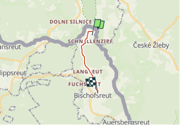
5,1 km | 6,8 km-effort
1h 32min
![](https://static1.geolcdn.com/siteimages/upload/files/16400158638029165_repeat_loop_refresh_sync_direction_icon.png)
Non
![Randonnée A pied Philippsreut - Soldanelle - Photo](https://media.geolcdn.com/t/375/260/8c452737-ba5c-48cf-946c-b9516cf7a468.jpeg&format=jpg&maxdim=2)
![A pied A pied](https://static1.geolcdn.com/sitytour/trail-icons/100.png)
Soldanelle
A pied
Moyen
Philippsreut,
Bavière,
Landkreis Freyung-Grafenau,
Allemagne
![](/images/other/stat-length.png)
21 km | 31 km-effort
6h 57min
![](https://static1.geolcdn.com/siteimages/upload/files/16400158638029165_repeat_loop_refresh_sync_direction_icon.png)
Non
![Randonnée A pied Philippsreut - Wanderweg Nr. 6 - Photo](https://media.geolcdn.com/t/375/260/0ae206e6-ad1d-40b8-9c1b-97d6cccd2d23.jpeg&format=jpg&maxdim=2)
![A pied A pied](https://static1.geolcdn.com/sitytour/trail-icons/100.png)
Wanderweg Nr. 6
A pied
Facile
Philippsreut,
Bavière,
Landkreis Freyung-Grafenau,
Allemagne
![](/images/other/stat-length.png)
3,5 km | 4,2 km-effort
57min
![](https://static1.geolcdn.com/siteimages/upload/files/16400158638029165_repeat_loop_refresh_sync_direction_icon.png)
Non
![Randonnée A pied Haidmühle - Rundwanderweg 3 Weberbachklause - Photo](https://media.geolcdn.com/t/375/260/ext.jpg?maxdim=2&url=https%3A%2F%2Fstatic1.geolcdn.com%2Fsiteimages%2Fupload%2Ffiles%2F1545311037marcheuse_200dpi.jpg)
![A pied A pied](https://static1.geolcdn.com/sitytour/trail-icons/100.png)
Rundwanderweg 3 Weberbachklause
A pied
Facile
Haidmühle,
Bavière,
Landkreis Freyung-Grafenau,
Allemagne
![](/images/other/stat-length.png)
7,2 km | 9,7 km-effort
2h 12min
![](https://static1.geolcdn.com/siteimages/upload/files/16400158638029165_repeat_loop_refresh_sync_direction_icon.png)
Oui