Randonnée A pied Lind - Booser Doppelmaartour - Photo

Tous les sentiers balisés d’Europe GUIDE+

© OpenStreetMap contributors
Longueur
Longueur
9,1 km
Altitude max
Altitude max
550 m
Dénivelé positif
Dénivelé positif
194 m
Km-Effort
Km-Effort  
11,7 km
Altitude min
Altitude min
450 m
Dénivelé négatif
Dénivelé négatif
198 m
Boucle
Boucle
Oui
Balise
Balise
Date de création :
2022-02-11 16:08:44.665
Dernière modification :
2022-02-11 16:08:44.665

(0 Avis)

A pied
A pied
2h38
Difficulté : Facile

Scannez ce code QR pour ouvrir la randonnée dans l'application SityTrail

Application GPS de randonnée GRATUITE

Logo SityTrail SityTrail

IGN / Instituts géographiques

Télécharger SityTrail sur l'App Store Télécharger SityTrail sur Google Play

Logo SityTrail SityTrail World

Le monde est à vous

Télécharger SityTrail sur l'App Store Télécharger SityTrail sur Google Play Télécharger SityTrail sur Huawei AppGallery

À propos

Randonnée A pied de 9,1 km à découvrir à Rhénanie-Palatinat, Landkreis Mayen-Koblenz, Lind. Cette randonnée est proposée par SityTrail - itinéraires balisés pédestres.

Description

Randonnée créée par Rhein-Mosel-Eifel-Touristik.

Symbole: Oranger Hintergrund, weißer Pfad, Text: Traumpfad

Profil altimétrique

Photos

Localisation

Pays :
Allemagne
Région :
Rhénanie-Palatinat
Département/Province :
Landkreis Mayen-Koblenz
Commune :
Lind
Localité :
Unknown
Départ:(UTM)
359911 ; 5576974 (32U) N.

Randonnées à proximité

Randonnée A pied Acht - Wanderather - Photo
A pied
GUIDE+

A pied

Facile
Acht, Rhénanie-Palatinat, Landkreis Mayen-Koblenz, Allemagne
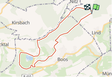
12,4 km | 17,1 km-effort
3h 52min
Non
Randonnée A pied Nürburg - Nürburg-Route - Photo
A pied
GUIDE+

A pied

Facile
Nürburg, Rhénanie-Palatinat, Landkreis Ahrweiler, Allemagne
4 km | 5,6 km-effort
1h 16min
Non
Randonnée A pied Virneburg - Virne-Burgweg - Photo
A pied
GUIDE+

A pied

Facile
Virneburg, Rhénanie-Palatinat, Landkreis Mayen-Koblenz, Allemagne
9,8 km | 13,7 km-effort
3h 6min
Oui
Randonnée A pied Boos - Wikiloc Boos Doppelmaren (PVDB) - Photo
A pied
GUIDE
Peter.vdbergh

A pied

Moyen
Boos, Rhénanie-Palatinat, Landkreis Mayen-Koblenz, Allemagne
9,1 km | 11,7 km-effort
2h 8min
Oui
Randonnée A pied Boos - Stumpfarmweg - Photo
A pied
GUIDE+

A pied

Facile
Boos, Rhénanie-Palatinat, Landkreis Mayen-Koblenz, Allemagne
6,9 km | 8,3 km-effort
1h 52min
Non
Randonnée A pied Bermel - Hochbermeler - Photo
A pied
GUIDE+

A pied

Facile
Bermel, Rhénanie-Palatinat, Landkreis Mayen-Koblenz, Allemagne
4 km | 5,7 km-effort
1h 18min
Non
Randonnée Moteur Meuspath - Nürburgring - Photo
Moteur
cwuidard

Moteur

Très facile
Meuspath, Rhénanie-Palatinat, Landkreis Ahrweiler, Allemagne
21 km | 27 km-effort
Inconnu
Oui
Randonnée Marche Boos - Trumpfade volcans Boos - Photo
Marche
Koa1a

Marche

Très facile
Boos, Rhénanie-Palatinat, Landkreis Mayen-Koblenz, Allemagne
10,4 km | 13,5 km-effort
2h 45min
Oui


Fermer
Mes abonnements