Randonnée A pied Helgoland - Geschichtspfad - Photo

Tous les sentiers balisés d’Europe GUIDE+

© OpenStreetMap contributors
Longueur
Longueur
3,6 km
Altitude max
Altitude max
52 m
Dénivelé positif
Dénivelé positif
91 m
Km-Effort
Km-Effort  
4,8 km
Altitude min
Altitude min
0 m
Dénivelé négatif
Dénivelé négatif
70 m
Boucle
Boucle
Non
Balise
Balise
Date de création :
2022-02-11 16:08:38.187
Dernière modification :
2022-02-11 16:08:38.187

(0 Avis)

A pied
A pied
1h05
Difficulté : Facile

Scannez ce code QR pour ouvrir la randonnée dans l'application SityTrail

Application GPS de randonnée GRATUITE

Logo SityTrail SityTrail

IGN / Instituts géographiques

Télécharger SityTrail sur l'App Store Télécharger SityTrail sur Google Play

Logo SityTrail SityTrail World

Le monde est à vous

Télécharger SityTrail sur l'App Store Télécharger SityTrail sur Google Play Télécharger SityTrail sur Huawei AppGallery

À propos

Randonnée A pied de 3,6 km à découvrir à Schleswig-Holstein, Pinneberg, Helgoland. Cette randonnée est proposée par SityTrail - itinéraires balisés pédestres.

Description

Der Weg ist nicht wirklich beschildert, er ergibt sich nur aus den gelben Informationstafeln

Profil altimétrique

Photos

Localisation

Pays :
Allemagne
Région :
Schleswig-Holstein
Département/Province :
Pinneberg
Commune :
Helgoland
Localité :
Unknown
Départ:(UTM)
427603 ; 6004246 (32U) N.

Randonnées à proximité

Randonnée A pied Helgoland - Naturlehrpfad - Photo
A pied
GUIDE+

A pied

Facile
Helgoland, Schleswig-Holstein, Pinneberg, Allemagne
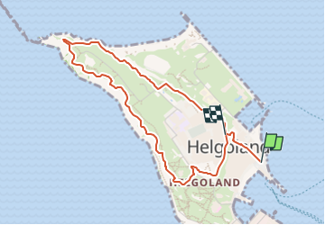
3,3 km | 3,4 km-effort
46min
Oui
Randonnée A pied Helgoland - Naturpfad - Photo
A pied
GUIDE+

A pied

Facile
Helgoland, Schleswig-Holstein, Pinneberg, Allemagne
4,7 km | 6,1 km-effort
1h 23min
Oui
Randonnée Marche Helgoland - Heligoland 1 - Photo
Marche
ppigeon

Marche

Très facile
Helgoland, Schleswig-Holstein, Pinneberg, Allemagne
2,3 km | 2,5 km-effort
1h 25min
Non


Fermer
Mes abonnements