![](/images/other/stat-length.png)
![Randonnée A pied Gerach - Fasanen-Wanderweg Gerach - Photo](https://media.geolcdn.com/t/1900/400/e18022a9-967a-4ec6-929c-d705af9ac5aa.jpeg&format=pjpeg&maxdim=2)
Fasanen-Wanderweg Gerach
SityTrail - itinéraires balisés pédestres
Tous les sentiers balisés d’Europe GUIDE+
![Longueur](/images/other/stat-length.png)
Longueur
6,7 km
![Altitude max](https://static1.geolcdn.com/siteimages/upload/files/1508320355ic_sort_altitude_max_24dp.png)
Altitude max
321 m
![Dénivelé positif](https://static1.geolcdn.com/siteimages/upload/files/1508320355ic_sort_den_pos_24dp.png)
Dénivelé positif
87 m
![Km-Effort](/images/other/stat-length.png)
Km-Effort
7,9 km
![Altitude min](https://static1.geolcdn.com/siteimages/upload/files/1508320355ic_sort_altitude_min_24dp.png)
Altitude min
265 m
![Dénivelé négatif](https://static1.geolcdn.com/siteimages/upload/files/1508320355ic_sort_den_neg_24dp.png)
Dénivelé négatif
87 m
![Boucle](https://static1.geolcdn.com/siteimages/upload/files/16400158638029165_repeat_loop_refresh_sync_direction_icon.png)
Boucle
Oui
Balise
Date de création :
2022-02-11 15:59:45.721
Dernière modification :
2022-02-11 15:59:45.721
![A pied](https://static1.geolcdn.com/sitytour/trail-icons/100.png)
1h47
Difficulté : Facile
![Scannez ce code QR pour ouvrir la randonnée dans l'application SityTrail](https://capi.geolives.com/qq0zvz2zws4bq2lad0pu/sitytour/trails/3095579/qr.png?size=200)
Application GPS de randonnée GRATUITE
À propos
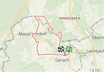
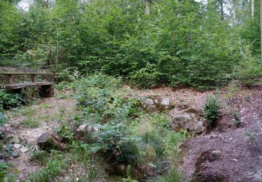
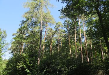
Randonnée A pied de 6,7 km à découvrir à Bavière, Landkreis Bamberg, Gerach. Cette randonnée est proposée par SityTrail - itinéraires balisés pédestres.
Description
ausgeschilderter Weg unterscheidet sich von Wandertafeln
Symbole: Schwarzer Fasan auf gelbem Grund
Localisation
Pays :
Allemagne
Région :
Bavière
Département/Province :
Landkreis Bamberg
Commune :
Gerach
Localité :
Unknown
Départ:(Dec)
Départ:(UTM)
629503 ; 5543766 (32U) N.
Commentaires
Randonnées à proximité
![Randonnée A pied Ebelsbach - Rundwanderweg Milan Rudendorf - Photo](https://media.geolcdn.com/t/375/260/caeb0628-07aa-48cc-9718-d1fd0de5c211.jpeg&format=jpg&maxdim=2)
![A pied A pied](https://static1.geolcdn.com/sitytour/trail-icons/100.png)
Rundwanderweg Milan Rudendorf
A pied
Facile
Ebelsbach,
Bavière,
Landkreis Haßberge,
Allemagne
![](/images/other/stat-length.png)
9,6 km | 12,3 km-effort
2h 47min
![](https://static1.geolcdn.com/siteimages/upload/files/16400158638029165_repeat_loop_refresh_sync_direction_icon.png)
Oui
![Randonnée A pied Breitbrunn - Rundwanderweg Hase Lußberg - Photo](https://media.geolcdn.com/t/375/260/7b754189-9687-4740-acc0-8c8b14bd3099.jpeg&format=jpg&maxdim=2)
![A pied A pied](https://static1.geolcdn.com/sitytour/trail-icons/100.png)
Rundwanderweg Hase Lußberg
A pied
Facile
Breitbrunn,
Bavière,
Landkreis Haßberge,
Allemagne
![](/images/other/stat-length.png)
7,1 km | 9,9 km-effort
2h 14min
![](https://static1.geolcdn.com/siteimages/upload/files/16400158638029165_repeat_loop_refresh_sync_direction_icon.png)
Oui
![Randonnée A pied Ebern - Rundwanderweg Schmetterling Ebern - Photo](https://media.geolcdn.com/t/375/260/c99a198e-7131-4b14-bcbd-39cee3336069.jpeg&format=jpg&maxdim=2)
![A pied A pied](https://static1.geolcdn.com/sitytour/trail-icons/100.png)
Rundwanderweg Schmetterling Ebern
A pied
Facile
Ebern,
Bavière,
Landkreis Haßberge,
Allemagne
![](/images/other/stat-length.png)
4,1 km | 5,2 km-effort
1h 10min
![](https://static1.geolcdn.com/siteimages/upload/files/16400158638029165_repeat_loop_refresh_sync_direction_icon.png)
Oui
![Randonnée A pied Baunach - Brauersteig - Photo](https://media.geolcdn.com/t/375/260/ae44bd57-8cd7-4971-bf16-723f9dd87ea4.jpeg&format=jpg&maxdim=2)
![A pied A pied](https://static1.geolcdn.com/sitytour/trail-icons/100.png)
Brauersteig
A pied
Facile
Baunach,
Bavière,
Landkreis Bamberg,
Allemagne
![](/images/other/stat-length.png)
13,9 km | 18,2 km-effort
4h 7min
![](https://static1.geolcdn.com/siteimages/upload/files/16400158638029165_repeat_loop_refresh_sync_direction_icon.png)
Non
![Randonnée A pied Baunach - Querkeltour - Photo](https://media.geolcdn.com/t/375/260/caeb0628-07aa-48cc-9718-d1fd0de5c211.jpeg&format=jpg&maxdim=2)
![A pied A pied](https://static1.geolcdn.com/sitytour/trail-icons/100.png)
Querkeltour
A pied
Moyen
Baunach,
Bavière,
Landkreis Bamberg,
Allemagne
![](/images/other/stat-length.png)
16,1 km | 21 km-effort
4h 42min
![](https://static1.geolcdn.com/siteimages/upload/files/16400158638029165_repeat_loop_refresh_sync_direction_icon.png)
Non
![Randonnée A pied Breitbrunn - Lauftour BRB1 - Photo](https://media.geolcdn.com/t/375/260/a35807d9-9af9-402d-9156-e8a9ce3a6610.jpeg&format=jpg&maxdim=2)
![A pied A pied](https://static1.geolcdn.com/sitytour/trail-icons/100.png)
Lauftour BRB1
A pied
Facile
Breitbrunn,
Bavière,
Landkreis Haßberge,
Allemagne
![](/images/other/stat-length.png)
9,8 km | 12,9 km-effort
2h 56min
![](https://static1.geolcdn.com/siteimages/upload/files/16400158638029165_repeat_loop_refresh_sync_direction_icon.png)
Oui
![Randonnée A pied Rattelsdorf - Wilschwein-Wanderweg Reckendorf - Photo](https://media.geolcdn.com/t/375/260/990c3ea7-9cef-4934-a842-326726d941f4.jpeg&format=jpg&maxdim=2)
![A pied A pied](https://static1.geolcdn.com/sitytour/trail-icons/100.png)
Wilschwein-Wanderweg Reckendorf
A pied
Facile
Rattelsdorf,
Bavière,
Landkreis Bamberg,
Allemagne
![](/images/other/stat-length.png)
11,2 km | 14,9 km-effort
3h 22min
![](https://static1.geolcdn.com/siteimages/upload/files/16400158638029165_repeat_loop_refresh_sync_direction_icon.png)
Non
![Randonnée A pied Rattelsdorf - Fasan-Wanderweg Mürsbach - Photo](https://media.geolcdn.com/t/375/260/8065cc6f-d83d-4677-807f-14717606e939.jpeg&format=jpg&maxdim=2)
![A pied A pied](https://static1.geolcdn.com/sitytour/trail-icons/100.png)
Fasan-Wanderweg Mürsbach
A pied
Facile
Rattelsdorf,
Bavière,
Landkreis Bamberg,
Allemagne
![](/images/other/stat-length.png)
6,5 km | 8,9 km-effort
2h 1min
![](https://static1.geolcdn.com/siteimages/upload/files/16400158638029165_repeat_loop_refresh_sync_direction_icon.png)
Oui
![Randonnée A pied Rattelsdorf - Dachs-Wanderweg Mürsbach - Photo](https://media.geolcdn.com/t/375/260/8065cc6f-d83d-4677-807f-14717606e939.jpeg&format=jpg&maxdim=2)
![A pied A pied](https://static1.geolcdn.com/sitytour/trail-icons/100.png)
Dachs-Wanderweg Mürsbach
A pied
Facile
Rattelsdorf,
Bavière,
Landkreis Bamberg,
Allemagne
![](/images/other/stat-length.png)
10,6 km | 14,3 km-effort
3h 15min
![](https://static1.geolcdn.com/siteimages/upload/files/16400158638029165_repeat_loop_refresh_sync_direction_icon.png)
Oui