![](/images/other/stat-length.png)
![Randonnée A pied Paderborn - Paderborner Karstrundweg - Photo](https://media.geolcdn.com/t/1900/400/ext.pjpeg?maxdim=2&url=https%3A%2F%2Fmedia.geolcdn.com%2Ff%2F04b17e81-542a-4fe8-ba5c-31ce6461a159.jpeg)
Paderborner Karstrundweg
SityTrail - itinéraires balisés pédestres
Tous les sentiers balisés d’Europe PRO
![Longueur](/images/other/stat-length.png)
Longueur
13,3 km
![Altitude max](https://static1.geolcdn.com/siteimages/upload/files/1508320355ic_sort_altitude_max_24dp.png)
Altitude max
351 m
![Dénivelé positif](https://static1.geolcdn.com/siteimages/upload/files/1508320355ic_sort_den_pos_24dp.png)
Dénivelé positif
286 m
![Km-Effort](/images/other/stat-length.png)
Km-Effort
17 km
![Altitude min](https://static1.geolcdn.com/siteimages/upload/files/1508320355ic_sort_altitude_min_24dp.png)
Altitude min
210 m
![Dénivelé négatif](https://static1.geolcdn.com/siteimages/upload/files/1508320355ic_sort_den_neg_24dp.png)
Dénivelé négatif
259 m
![Boucle](https://static1.geolcdn.com/siteimages/upload/files/16400158638029165_repeat_loop_refresh_sync_direction_icon.png)
Boucle
Non
Balise
Date de création :
2022-02-11 15:44:56.946
Dernière modification :
2022-02-11 15:44:56.946
![A pied](https://static1.geolcdn.com/sitytour/trail-icons/100.png)
3h51
Difficulté : Facile
![Scannez ce code QR pour ouvrir la randonnée dans l'application SityTrail](https://capi.geolives.com/qq0zvz2zws4bq2lad0pu/sitytour/trails/3095185/qr.png?size=200)
Application GPS de randonnée GRATUITE
À propos
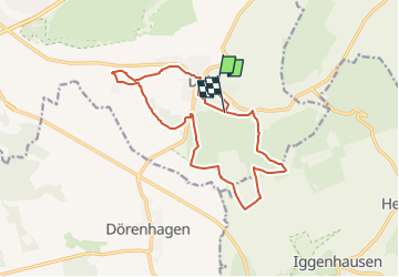
Randonnée A pied de 13,3 km à découvrir à Rhénanie-du-Nord-Westphalie, Kreis Paderborn, Paderborn. Cette randonnée est proposée par SityTrail - itinéraires balisés pédestres.
Description
Sonnige Runde vom Ellerbachtal auf die Paderborner Hochfläche
Site web: http://www.paderborner-karstrundweg.de
Localisation
Pays :
Allemagne
Région :
Rhénanie-du-Nord-Westphalie
Département/Province :
Kreis Paderborn
Commune :
Paderborn
Localité :
Unknown
Départ:(Dec)
Départ:(UTM)
490049 ; 5726978 (32U) N.
Commentaires
Randonnées à proximité
![Randonnée A pied Paderborn - Dahl Rundweg A1 - Photo](https://media.geolcdn.com/t/375/260/ext.jpg?maxdim=2&url=https%3A%2F%2Fmedia.geolcdn.com%2Ff%2F37f14937-af38-4247-a5c2-932d8cd6427a.jpeg)
![A pied A pied](https://static1.geolcdn.com/sitytour/trail-icons/100.png)
Dahl Rundweg A1
A pied
Facile
Paderborn,
Rhénanie-du-Nord-Westphalie,
Kreis Paderborn,
Allemagne
![](/images/other/stat-length.png)
3,6 km | 4,5 km-effort
1h 1min
![](https://static1.geolcdn.com/siteimages/upload/files/16400158638029165_repeat_loop_refresh_sync_direction_icon.png)
Oui
![Randonnée A pied Altenbeken - Schwaneyer Panoramaweg - Photo](https://media.geolcdn.com/t/375/260/ext.jpg?maxdim=2&url=https%3A%2F%2Fmedia.geolcdn.com%2Ff%2F6677e685-b94e-4aaf-ac5f-a6be76346ebc.jpeg)
![A pied A pied](https://static1.geolcdn.com/sitytour/trail-icons/100.png)
Schwaneyer Panoramaweg
A pied
Facile
Altenbeken,
Rhénanie-du-Nord-Westphalie,
Kreis Paderborn,
Allemagne
![](/images/other/stat-length.png)
12,2 km | 16 km-effort
3h 38min
![](https://static1.geolcdn.com/siteimages/upload/files/16400158638029165_repeat_loop_refresh_sync_direction_icon.png)
Non
![Randonnée A pied Paderborn - Dahler Aussichtstour - Photo](https://media.geolcdn.com/t/375/260/ext.jpg?maxdim=2&url=https%3A%2F%2Fmedia.geolcdn.com%2Ff%2F803a2156-810f-49e6-a52f-f1b8d804bcd3.jpeg)
![A pied A pied](https://static1.geolcdn.com/sitytour/trail-icons/100.png)
Dahler Aussichtstour
A pied
Facile
Paderborn,
Rhénanie-du-Nord-Westphalie,
Kreis Paderborn,
Allemagne
![](/images/other/stat-length.png)
12,9 km | 15,8 km-effort
3h 35min
![](https://static1.geolcdn.com/siteimages/upload/files/16400158638029165_repeat_loop_refresh_sync_direction_icon.png)
Non
![Randonnée A pied Paderborn - Rundweg Benhausen - Photo](https://media.geolcdn.com/t/375/260/ext.jpg?maxdim=2&url=https%3A%2F%2Fmedia.geolcdn.com%2Ff%2F2525b3f8-20b6-4a1b-a6d5-1753b3cff568.jpeg)
![A pied A pied](https://static1.geolcdn.com/sitytour/trail-icons/100.png)
Rundweg Benhausen
A pied
Facile
Paderborn,
Rhénanie-du-Nord-Westphalie,
Kreis Paderborn,
Allemagne
![](/images/other/stat-length.png)
9,1 km | 10,6 km-effort
2h 25min
![](https://static1.geolcdn.com/siteimages/upload/files/16400158638029165_repeat_loop_refresh_sync_direction_icon.png)
Oui
![Randonnée A pied Altenbeken - Rundwanderweg A2 [Dune] - Photo](https://media.geolcdn.com/t/375/260/ext.jpg?maxdim=2&url=https%3A%2F%2Fmedia.geolcdn.com%2Ff%2Ff67a66a4-5038-45ed-847b-184bff3ced0b.jpeg)
![A pied A pied](https://static1.geolcdn.com/sitytour/trail-icons/100.png)
Rundwanderweg A2 [Dune]
A pied
Facile
Altenbeken,
Rhénanie-du-Nord-Westphalie,
Kreis Paderborn,
Allemagne
![](/images/other/stat-length.png)
5,1 km | 6,6 km-effort
1h 29min
![](https://static1.geolcdn.com/siteimages/upload/files/16400158638029165_repeat_loop_refresh_sync_direction_icon.png)
Oui
![Randonnée A pied Borchen - Haxtergrund Rundweg Gelb - Photo](https://media.geolcdn.com/t/375/260/ext.jpg?maxdim=2&url=https%3A%2F%2Fmedia.geolcdn.com%2Ff%2Fc6b355c0-39d6-4653-84cd-f09aa3d6e194.jpeg)
![A pied A pied](https://static1.geolcdn.com/sitytour/trail-icons/100.png)
Haxtergrund Rundweg Gelb
A pied
Facile
Borchen,
Rhénanie-du-Nord-Westphalie,
Kreis Paderborn,
Allemagne
![](/images/other/stat-length.png)
5,1 km | 6,7 km-effort
1h 31min
![](https://static1.geolcdn.com/siteimages/upload/files/16400158638029165_repeat_loop_refresh_sync_direction_icon.png)
Oui
![Randonnée A pied Paderborn - Haxtergrund Rundweg Rot - Photo](https://media.geolcdn.com/t/375/260/ext.jpg?maxdim=2&url=https%3A%2F%2Fmedia.geolcdn.com%2Ff%2Fd99722c6-14b3-4850-8db9-9972bab85971.jpeg)
![A pied A pied](https://static1.geolcdn.com/sitytour/trail-icons/100.png)
Haxtergrund Rundweg Rot
A pied
Facile
Paderborn,
Rhénanie-du-Nord-Westphalie,
Kreis Paderborn,
Allemagne
![](/images/other/stat-length.png)
5,9 km | 7,2 km-effort
1h 38min
![](https://static1.geolcdn.com/siteimages/upload/files/16400158638029165_repeat_loop_refresh_sync_direction_icon.png)
Oui
![Randonnée A pied Paderborn - Haxtergrund Rundweg Violett - Photo](https://media.geolcdn.com/t/375/260/ext.jpg?maxdim=2&url=https%3A%2F%2Fmedia.geolcdn.com%2Ff%2Fc6b355c0-39d6-4653-84cd-f09aa3d6e194.jpeg)
![A pied A pied](https://static1.geolcdn.com/sitytour/trail-icons/100.png)
Haxtergrund Rundweg Violett
A pied
Facile
Paderborn,
Rhénanie-du-Nord-Westphalie,
Kreis Paderborn,
Allemagne
![](/images/other/stat-length.png)
3,9 km | 5,1 km-effort
1h 10min
![](https://static1.geolcdn.com/siteimages/upload/files/16400158638029165_repeat_loop_refresh_sync_direction_icon.png)
Oui
![Randonnée A pied Paderborn - Mittelholz - Photo](https://media.geolcdn.com/t/375/260/ext.jpg?maxdim=2&url=https%3A%2F%2Fmedia.geolcdn.com%2Ff%2F6f45a554-454d-4ef5-9436-3fff121cf73c.jpeg)
![A pied A pied](https://static1.geolcdn.com/sitytour/trail-icons/100.png)
Mittelholz
A pied
Facile
Paderborn,
Rhénanie-du-Nord-Westphalie,
Kreis Paderborn,
Allemagne
![](/images/other/stat-length.png)
3,3 km | 4,3 km-effort
58min
![](https://static1.geolcdn.com/siteimages/upload/files/16400158638029165_repeat_loop_refresh_sync_direction_icon.png)
Non