![](/images/other/stat-length.png)
![Randonnée A pied Waldbrunn - Verbindungsweg Brummerkreuz - Unterdielbach - Photo](https://media.geolcdn.com/t/1900/400/c0770678-ac75-4e0f-ae4c-3c8172d15d0b.jpeg&format=pjpeg&maxdim=2)
Verbindungsweg Brummerkreuz - Unterdielbach
SityTrail - itinéraires balisés pédestres
Tous les sentiers balisés d’Europe GUIDE+
![Longueur](/images/other/stat-length.png)
Longueur
3,2 km
![Altitude max](https://static1.geolcdn.com/siteimages/upload/files/1508320355ic_sort_altitude_max_24dp.png)
Altitude max
539 m
![Dénivelé positif](https://static1.geolcdn.com/siteimages/upload/files/1508320355ic_sort_den_pos_24dp.png)
Dénivelé positif
13 m
![Km-Effort](/images/other/stat-length.png)
Km-Effort
3,5 km
![Altitude min](https://static1.geolcdn.com/siteimages/upload/files/1508320355ic_sort_altitude_min_24dp.png)
Altitude min
489 m
![Dénivelé négatif](https://static1.geolcdn.com/siteimages/upload/files/1508320355ic_sort_den_neg_24dp.png)
Dénivelé négatif
51 m
![Boucle](https://static1.geolcdn.com/siteimages/upload/files/16400158638029165_repeat_loop_refresh_sync_direction_icon.png)
Boucle
Non
Balise
Date de création :
2022-02-11 15:42:14.526
Dernière modification :
2022-02-11 15:42:14.526
![A pied](https://static1.geolcdn.com/sitytour/trail-icons/100.png)
47m
Difficulté : Facile
![Scannez ce code QR pour ouvrir la randonnée dans l'application SityTrail](https://capi.geolives.com/qq0zvz2zws4bq2lad0pu/sitytour/trails/3095084/qr.png?size=200)
Application GPS de randonnée GRATUITE
À propos
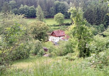
Randonnée A pied de 3,2 km à découvrir à Bade-Wurtemberg, Neckar-Odenwald-Kreis, Waldbrunn. Cette randonnée est proposée par SityTrail - itinéraires balisés pédestres.
Description
Randonnée créée par Naturpark Neckartal-Odenwald.
Der südliche Teil nach Unterdielbach fehlt noch
Symbole: Gelbes V in gelbem Kreis
Localisation
Pays :
Allemagne
Région :
Bade-Wurtemberg
Département/Province :
Neckar-Odenwald-Kreis
Commune :
Waldbrunn
Localité :
Unknown
Départ:(Dec)
Départ:(UTM)
504991 ; 5479099 (32U) N.
Commentaires
Randonnées à proximité
![Randonnée A pied Eberbach - Rundwanderweg 3: Burg-Eberbach-Weg - Photo](https://media.geolcdn.com/t/375/260/474ee3c4-c561-4de5-a4ca-5c5cf81b0a8d.jpeg&format=jpg&maxdim=2)
![A pied A pied](https://static1.geolcdn.com/sitytour/trail-icons/100.png)
Rundwanderweg 3: Burg-Eberbach-Weg
A pied
Facile
Eberbach,
Bade-Wurtemberg,
Rhein-Neckar-Kreis,
Allemagne
![](/images/other/stat-length.png)
4,7 km | 7,1 km-effort
1h 37min
![](https://static1.geolcdn.com/siteimages/upload/files/16400158638029165_repeat_loop_refresh_sync_direction_icon.png)
Non
![Randonnée A pied Waldbrunn - Naturpark-Rundweg 47 - Photo](https://media.geolcdn.com/t/375/260/77810ae3-d381-45e2-9df2-5a2f8beb1c16.jpeg&format=jpg&maxdim=2)
![A pied A pied](https://static1.geolcdn.com/sitytour/trail-icons/100.png)
Naturpark-Rundweg 47
A pied
Facile
Waldbrunn,
Bade-Wurtemberg,
Neckar-Odenwald-Kreis,
Allemagne
![](/images/other/stat-length.png)
7,2 km | 9,8 km-effort
2h 14min
![](https://static1.geolcdn.com/siteimages/upload/files/16400158638029165_repeat_loop_refresh_sync_direction_icon.png)
Oui
![Randonnée A pied Mudau - Rundwanderweg Reisenbacher Grund 2 - Photo](https://media.geolcdn.com/t/375/260/6cf51887-16d0-4acd-b6e2-781bb006eb35.jpeg&format=jpg&maxdim=2)
![A pied A pied](https://static1.geolcdn.com/sitytour/trail-icons/100.png)
Rundwanderweg Reisenbacher Grund 2
A pied
Facile
Mudau,
Bade-Wurtemberg,
Neckar-Odenwald-Kreis,
Allemagne
![](/images/other/stat-length.png)
6,9 km | 9,8 km-effort
2h 13min
![](https://static1.geolcdn.com/siteimages/upload/files/16400158638029165_repeat_loop_refresh_sync_direction_icon.png)
Non
![Randonnée A pied Mudau - Rundwanderweg Reisenbacher Grund 3 - Photo](https://media.geolcdn.com/t/375/260/6cf51887-16d0-4acd-b6e2-781bb006eb35.jpeg&format=jpg&maxdim=2)
![A pied A pied](https://static1.geolcdn.com/sitytour/trail-icons/100.png)
Rundwanderweg Reisenbacher Grund 3
A pied
Facile
Mudau,
Bade-Wurtemberg,
Neckar-Odenwald-Kreis,
Allemagne
![](/images/other/stat-length.png)
6,4 km | 9,1 km-effort
2h 3min
![](https://static1.geolcdn.com/siteimages/upload/files/16400158638029165_repeat_loop_refresh_sync_direction_icon.png)
Oui
![Randonnée A pied Mudau - Rundwanderweg Reisenbach 2 - Photo](https://media.geolcdn.com/t/375/260/db5d1d3e-2ab1-451c-b7bd-f4fc8a0407d4.jpeg&format=jpg&maxdim=2)
![A pied A pied](https://static1.geolcdn.com/sitytour/trail-icons/100.png)
Rundwanderweg Reisenbach 2
A pied
Facile
Mudau,
Bade-Wurtemberg,
Neckar-Odenwald-Kreis,
Allemagne
![](/images/other/stat-length.png)
6,8 km | 8,7 km-effort
1h 58min
![](https://static1.geolcdn.com/siteimages/upload/files/16400158638029165_repeat_loop_refresh_sync_direction_icon.png)
Oui
![Randonnée A pied Eberbach - Rundwanderweg Breitenstein 4: Wolfs-Weg - Photo](https://media.geolcdn.com/t/375/260/fd43d99f-3805-4567-b00e-d10c4f995918.jpeg&format=jpg&maxdim=2)
![A pied A pied](https://static1.geolcdn.com/sitytour/trail-icons/100.png)
Rundwanderweg Breitenstein 4: Wolfs-Weg
A pied
Facile
Eberbach,
Bade-Wurtemberg,
Rhein-Neckar-Kreis,
Allemagne
![](/images/other/stat-length.png)
8 km | 11 km-effort
2h 29min
![](https://static1.geolcdn.com/siteimages/upload/files/16400158638029165_repeat_loop_refresh_sync_direction_icon.png)
Non
![Randonnée A pied Waldbrunn - Rundwanderweg 51: Holdergrund-Weg - Photo](https://media.geolcdn.com/t/375/260/60904063-6a6d-40c9-8b9d-e9c3be9421c4.jpeg&format=jpg&maxdim=2)
![A pied A pied](https://static1.geolcdn.com/sitytour/trail-icons/100.png)
Rundwanderweg 51: Holdergrund-Weg
A pied
Facile
Waldbrunn,
Bade-Wurtemberg,
Neckar-Odenwald-Kreis,
Allemagne
![](/images/other/stat-length.png)
3,1 km | 4,1 km-effort
55min
![](https://static1.geolcdn.com/siteimages/upload/files/16400158638029165_repeat_loop_refresh_sync_direction_icon.png)
Non
![Randonnée A pied Waldbrunn - Naturpark-Rundweg 48 - Photo](https://media.geolcdn.com/t/375/260/67dfc0e9-9ff3-4d1f-92a1-fc7e99cc8f8d.jpeg&format=jpg&maxdim=2)
![A pied A pied](https://static1.geolcdn.com/sitytour/trail-icons/100.png)
Naturpark-Rundweg 48
A pied
Facile
Waldbrunn,
Bade-Wurtemberg,
Neckar-Odenwald-Kreis,
Allemagne
![](/images/other/stat-length.png)
6 km | 7,9 km-effort
1h 47min
![](https://static1.geolcdn.com/siteimages/upload/files/16400158638029165_repeat_loop_refresh_sync_direction_icon.png)
Oui
![Randonnée A pied Waldbrunn - Katzenpfad - Photo](https://media.geolcdn.com/t/375/260/d4f0025c-bbd1-41f1-9502-0e3fb2895241.jpeg&format=jpg&maxdim=2)
![A pied A pied](https://static1.geolcdn.com/sitytour/trail-icons/100.png)
Katzenpfad
A pied
Facile
Waldbrunn,
Bade-Wurtemberg,
Neckar-Odenwald-Kreis,
Allemagne
![](/images/other/stat-length.png)
5,1 km | 7,9 km-effort
1h 47min
![](https://static1.geolcdn.com/siteimages/upload/files/16400158638029165_repeat_loop_refresh_sync_direction_icon.png)
Non