![](/images/other/stat-length.png)
![Randonnée A pied Rettenbach - Rundweg Hölle - Photo](https://media.geolcdn.com/t/1900/400/341294d3-5eda-4b50-a960-3eb760a86047.jpeg&format=pjpeg&maxdim=2)
Rundweg Hölle
SityTrail - itinéraires balisés pédestres
Tous les sentiers balisés d’Europe GUIDE+
![Longueur](/images/other/stat-length.png)
Longueur
3,5 km
![Altitude max](https://static1.geolcdn.com/siteimages/upload/files/1508320355ic_sort_altitude_max_24dp.png)
Altitude max
570 m
![Dénivelé positif](https://static1.geolcdn.com/siteimages/upload/files/1508320355ic_sort_den_pos_24dp.png)
Dénivelé positif
86 m
![Km-Effort](/images/other/stat-length.png)
Km-Effort
4,6 km
![Altitude min](https://static1.geolcdn.com/siteimages/upload/files/1508320355ic_sort_altitude_min_24dp.png)
Altitude min
495 m
![Dénivelé négatif](https://static1.geolcdn.com/siteimages/upload/files/1508320355ic_sort_den_neg_24dp.png)
Dénivelé négatif
82 m
![Boucle](https://static1.geolcdn.com/siteimages/upload/files/16400158638029165_repeat_loop_refresh_sync_direction_icon.png)
Boucle
Oui
Balise
Date de création :
2022-02-11 15:25:05.546
Dernière modification :
2022-02-11 15:25:05.546
![A pied](https://static1.geolcdn.com/sitytour/trail-icons/100.png)
1h02
Difficulté : Facile
![Scannez ce code QR pour ouvrir la randonnée dans l'application SityTrail](https://capi.geolives.com/qq0zvz2zws4bq2lad0pu/sitytour/trails/3094457/qr.png?size=200)
Application GPS de randonnée GRATUITE
À propos
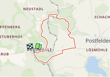
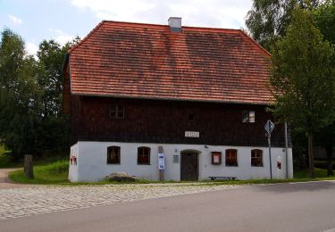
Randonnée A pied de 3,5 km à découvrir à Bavière, Landkreis Cham, Rettenbach. Cette randonnée est proposée par SityTrail - itinéraires balisés pédestres.
Description
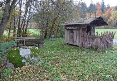
Symbole: Weißes, rechteckiges Schild mit rotem Rand, oben rote Aufschrift "Rundweg Hölle", unten roter Richtungspfeil (rechts oder links)
Localisation
Pays :
Allemagne
Région :
Bavière
Département/Province :
Landkreis Cham
Commune :
Rettenbach
Localité :
Unknown
Départ:(Dec)
Départ:(UTM)
311631 ; 5439313 (33U) N.
Commentaires
Randonnées à proximité
![Randonnée A pied Brennberg - T 8 Frauenzell - Breitenstein - Kruckenberg - Photo](https://media.geolcdn.com/t/375/260/76ab2507-fb3f-4eb5-aff2-71bc088be386.jpeg&format=jpg&maxdim=2)
![A pied A pied](https://static1.geolcdn.com/sitytour/trail-icons/100.png)
T 8 Frauenzell - Breitenstein - Kruckenberg
A pied
Facile
Brennberg,
Bavière,
Landkreis Regensburg,
Allemagne
![](/images/other/stat-length.png)
4,2 km | 5,8 km-effort
1h 18min
![](https://static1.geolcdn.com/siteimages/upload/files/16400158638029165_repeat_loop_refresh_sync_direction_icon.png)
Non
![Randonnée A pied Brennberg - T 6 Frauenzell - Bach/Do. - Photo](https://media.geolcdn.com/t/375/260/76ab2507-fb3f-4eb5-aff2-71bc088be386.jpeg&format=jpg&maxdim=2)
![A pied A pied](https://static1.geolcdn.com/sitytour/trail-icons/100.png)
T 6 Frauenzell - Bach/Do.
A pied
Facile
Brennberg,
Bavière,
Landkreis Regensburg,
Allemagne
![](/images/other/stat-length.png)
10,3 km | 13,2 km-effort
2h 59min
![](https://static1.geolcdn.com/siteimages/upload/files/16400158638029165_repeat_loop_refresh_sync_direction_icon.png)
Non
![Randonnée A pied Brennberg - T 1 Frauenzell - Hammermühle - Photo](https://media.geolcdn.com/t/375/260/76ab2507-fb3f-4eb5-aff2-71bc088be386.jpeg&format=jpg&maxdim=2)
![A pied A pied](https://static1.geolcdn.com/sitytour/trail-icons/100.png)
T 1 Frauenzell - Hammermühle
A pied
Facile
Brennberg,
Bavière,
Landkreis Regensburg,
Allemagne
![](/images/other/stat-length.png)
7,4 km | 9,2 km-effort
2h 5min
![](https://static1.geolcdn.com/siteimages/upload/files/16400158638029165_repeat_loop_refresh_sync_direction_icon.png)
Non
![Randonnée A pied Brennberg - Goldsteigzubringer Höllbachtal - Photo](https://media.geolcdn.com/t/375/260/b66b4f86-9a24-44fe-8dae-326bf882b2f0.jpeg&format=jpg&maxdim=2)
![A pied A pied](https://static1.geolcdn.com/sitytour/trail-icons/100.png)
Goldsteigzubringer Höllbachtal
A pied
Facile
Brennberg,
Bavière,
Landkreis Regensburg,
Allemagne
![](/images/other/stat-length.png)
4,6 km | 5,7 km-effort
1h 17min
![](https://static1.geolcdn.com/siteimages/upload/files/16400158638029165_repeat_loop_refresh_sync_direction_icon.png)
Non
![Randonnée A pied Wiesent - O 50 Wiesent - Gfäll (Rotes Dreieck) - Photo](https://media.geolcdn.com/t/375/260/b66b4f86-9a24-44fe-8dae-326bf882b2f0.jpeg&format=jpg&maxdim=2)
![A pied A pied](https://static1.geolcdn.com/sitytour/trail-icons/100.png)
O 50 Wiesent - Gfäll (Rotes Dreieck)
A pied
Facile
Wiesent,
Bavière,
Landkreis Regensburg,
Allemagne
![](/images/other/stat-length.png)
7,4 km | 10,3 km-effort
2h 20min
![](https://static1.geolcdn.com/siteimages/upload/files/16400158638029165_repeat_loop_refresh_sync_direction_icon.png)
Non
![Randonnée A pied Brennberg - O 53 Höllbachtal - Frauenzell (Grünes Rechteck) - Photo](https://media.geolcdn.com/t/375/260/25632bcf-ab56-47c3-b425-f55cbac61b12.jpeg&format=jpg&maxdim=2)
![A pied A pied](https://static1.geolcdn.com/sitytour/trail-icons/100.png)
O 53 Höllbachtal - Frauenzell (Grünes Rechteck)
A pied
Facile
Brennberg,
Bavière,
Landkreis Regensburg,
Allemagne
![](/images/other/stat-length.png)
6 km | 8,2 km-effort
1h 51min
![](https://static1.geolcdn.com/siteimages/upload/files/16400158638029165_repeat_loop_refresh_sync_direction_icon.png)
Non
![Randonnée A pied Rettenbach - Wilder Mann 149, Naturpark Vorderer Bayerischer Wald - Photo](https://media.geolcdn.com/t/375/260/530773e7-0c8c-4fad-ab0c-c5185028f559.jpeg&format=jpg&maxdim=2)
![A pied A pied](https://static1.geolcdn.com/sitytour/trail-icons/100.png)
Wilder Mann 149, Naturpark Vorderer Bayerischer Wald
A pied
Facile
Rettenbach,
Bavière,
Landkreis Cham,
Allemagne
![](/images/other/stat-length.png)
5,7 km | 7,3 km-effort
1h 39min
![](https://static1.geolcdn.com/siteimages/upload/files/16400158638029165_repeat_loop_refresh_sync_direction_icon.png)
Non
![Randonnée A pied Falkenstein - Falkensteiner Kräuterweg - Photo](https://media.geolcdn.com/t/375/260/ext.jpg?maxdim=2&url=https%3A%2F%2Fstatic1.geolcdn.com%2Fsiteimages%2Fupload%2Ffiles%2F1545311037marcheuse_200dpi.jpg)
![A pied A pied](https://static1.geolcdn.com/sitytour/trail-icons/100.png)
Falkensteiner Kräuterweg
A pied
Facile
Falkenstein,
Bavière,
Landkreis Cham,
Allemagne
![](/images/other/stat-length.png)
3,1 km | 4,2 km-effort
57min
![](https://static1.geolcdn.com/siteimages/upload/files/16400158638029165_repeat_loop_refresh_sync_direction_icon.png)
Non
![Randonnée A pied Brennberg - O 61 Frauenzell - Altenthann (Rotes Rechteck) - Photo](https://media.geolcdn.com/t/375/260/ext.jpg?maxdim=2&url=https%3A%2F%2Fstatic1.geolcdn.com%2Fsiteimages%2Fupload%2Ffiles%2F1545311037marcheuse_200dpi.jpg)
![A pied A pied](https://static1.geolcdn.com/sitytour/trail-icons/100.png)
O 61 Frauenzell - Altenthann (Rotes Rechteck)
A pied
Facile
Brennberg,
Bavière,
Landkreis Regensburg,
Allemagne
![](/images/other/stat-length.png)
3,9 km | 4,9 km-effort
1h 6min
![](https://static1.geolcdn.com/siteimages/upload/files/16400158638029165_repeat_loop_refresh_sync_direction_icon.png)
Non